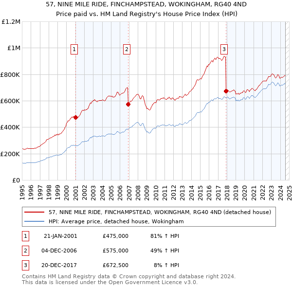
57 NINE MILE RIDE is a very large extended detached house of 181m², built sometime between 1996 and 2002. It was last sold for £672,500 in December 2017, which was around 8% above the average December 2017 detached price in the Wokingham local authority area. The most recent EPC inspection was November 2016, where the current energy rating was D, and the potential energy rating was C.
The below graph shows the average detached house price in the Wokingham local authority area over time, sourced from the HPI. The three 57 NINE MILE RIDE sales between January 2001 and December 2017 have been plotted on the graph. A line has been extrapolated to show what the value of the property might have been over time, following each sale, had it maintained the same margin above or below the HPI (as a percentage). For example, the December 2006 sale was for 49% above the HPI. So the extrapolation line tracks at 49% above the HPI over time, until the December 2017 sale, where it falls to 8% above the HPI. The line then continues to track at 8% above the HPI.
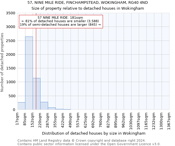
57 NINE MILE RIDE is 181m², which includes one extension, according to the EPC inspection conducted in November 2016. This puts it in the largest 20% of detached houses in Wokingham, based on EPC data. The below chart shows the distribution of detached houses by size in Wokingham, and where 57 NINE MILE RIDE lies on this distribution: 81% of detached houses are smaller than 57 NINE MILE RIDE, and 19% of houses are larger. Note that EPC data is not available for all properties in Wokingham.
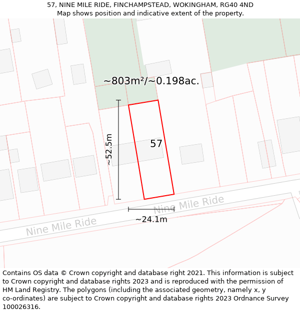
57 NINE MILE RIDE sits on a plot of roughly 0.198 of an acre, or 803m². The below map shows the location of 57 NINE MILE RIDE, an approximate outline of the building(s), and the indicative extent of the property. The plot extent is a Land Registry INSPIRE Index Polygon, and it is important to note that a title may include more than one polygon, whereas only one polygon is shown on the map (the polygon which intersects with the position of 57 NINE MILE RIDE). The full extent of the land contained in any registered title can only be identified from the individual title plan. The maps on this page should not be relied upon to establish the extent of a title.
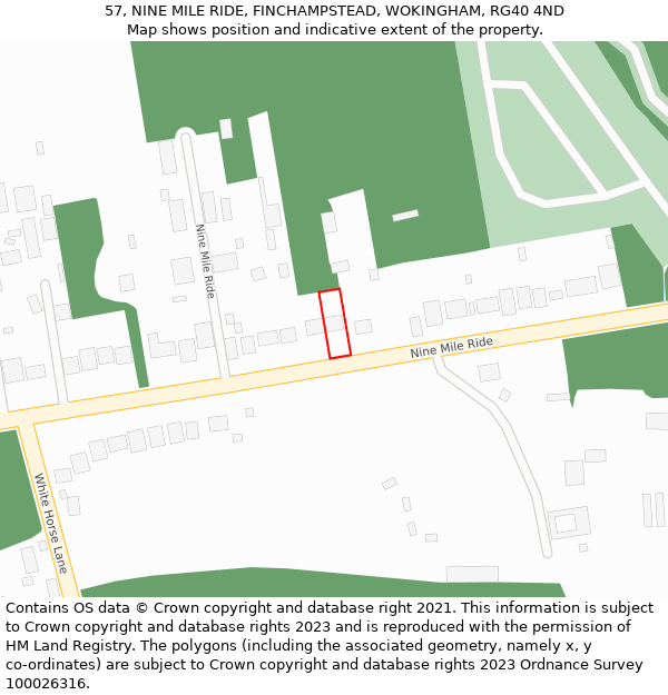
57 NINE MILE RIDE is located in FINCHAMPSTEAD, in the RG40 postcode district. The below map shows the position of No. 57 on NINE MILE RIDE.
All sales of detached houses on NINE MILE RIDE
345, NINE MILE RIDE, FINCHAMPSTEAD, WOKINGHAM, RG40 3NH
240, NINE MILE RIDE, FINCHAMPSTEAD, WOKINGHAM, RG40 3QD
287, NINE MILE RIDE, FINCHAMPSTEAD, WOKINGHAM, RG40 3NS
230, NINE MILE RIDE, FINCHAMPSTEAD, WOKINGHAM, RG40 3QD
286A, NINE MILE RIDE, FINCHAMPSTEAD, WOKINGHAM, RG40 3NT
206, NINE MILE RIDE, FINCHAMPSTEAD, WOKINGHAM, RG40 3PX
230, NINE MILE RIDE, FINCHAMPSTEAD, WOKINGHAM, RG40 3QD
188, NINE MILE RIDE, FINCHAMPSTEAD, WOKINGHAM, RG40 4JB
284, NINE MILE RIDE, FINCHAMPSTEAD, WOKINGHAM, RG40 3NT
23, NINE MILE RIDE, FINCHAMPSTEAD, WOKINGHAM, RG40 4QD
DENTAL SURGERY, 193, NINE MILE RIDE, FINCHAMPSTEAD, WOKINGHAM, RG40 4JD
47B, NINE MILE RIDE, FINCHAMPSTEAD, WOKINGHAM, RG40 4ND
41A, NINE MILE RIDE, FINCHAMPSTEAD, WOKINGHAM, RG40 4ND
244A, NINE MILE RIDE, FINCHAMPSTEAD, WOKINGHAM, RG40 3PA
177A, NINE MILE RIDE, FINCHAMPSTEAD, WOKINGHAM, RG40 4JD
243A, NINE MILE RIDE, FINCHAMPSTEAD, WOKINGHAM, RG40 3NY
241B, NINE MILE RIDE, FINCHAMPSTEAD, WOKINGHAM, RG40 3NY
348A, NINE MILE RIDE, FINCHAMPSTEAD, WOKINGHAM, RG40 3NJ
343, NINE MILE RIDE, FINCHAMPSTEAD, WOKINGHAM, RG40 3NH
285, NINE MILE RIDE, FINCHAMPSTEAD, WOKINGHAM, RG40 3NS
216, NINE MILE RIDE, FINCHAMPSTEAD, WOKINGHAM, RG40 3QD
322, NINE MILE RIDE, FINCHAMPSTEAD, WOKINGHAM, RG40 3NN
THE PENTRE, NINE MILE RIDE, FINCHAMPSTEAD, WOKINGHAM, RG40 4QB
304, NINE MILE RIDE, FINCHAMPSTEAD, WOKINGHAM, RG40 3NN
271, NINE MILE RIDE, FINCHAMPSTEAD, WOKINGHAM, RG40 3NS
269, NINE MILE RIDE, FINCHAMPSTEAD, WOKINGHAM, RG40 3NS
248, NINE MILE RIDE, FINCHAMPSTEAD, WOKINGHAM, RG40 3PA
15, NINE MILE RIDE, FINCHAMPSTEAD, WOKINGHAM, RG40 4QD
351, NINE MILE RIDE, FINCHAMPSTEAD, WOKINGHAM, RG40 3NH
57, NINE MILE RIDE, FINCHAMPSTEAD, WOKINGHAM, RG40 4ND
209, NINE MILE RIDE, WOKINGHAM, RG40 3QA
147A, NINE MILE RIDE, FINCHAMPSTEAD, WOKINGHAM, RG40 4HY
313, NINE MILE RIDE, FINCHAMPSTEAD, WOKINGHAM, RG40 3NL
PENTRE STABLE, NINE MILE RIDE, FINCHAMPSTEAD, WOKINGHAM, RG40 4QB
308, NINE MILE RIDE, FINCHAMPSTEAD, WOKINGHAM, RG40 3NN
214, NINE MILE RIDE, FINCHAMPSTEAD, WOKINGHAM, RG40 3QD
215, NINE MILE RIDE, WOKINGHAM, RG40 3QA
265, NINE MILE RIDE, FINCHAMPSTEAD, WOKINGHAM, RG40 3NS
333, NINE MILE RIDE, FINCHAMPSTEAD, WOKINGHAM, RG40 3NH
304, NINE MILE RIDE, FINCHAMPSTEAD, WOKINGHAM, RG40 3NN
304, NINE MILE RIDE, FINCHAMPSTEAD, WOKINGHAM, RG40 3NN
208, NINE MILE RIDE, FINCHAMPSTEAD, WOKINGHAM, RG40 3PX
162C, NINE MILE RIDE, FINCHAMPSTEAD, WOKINGHAM, RG40 4JA
331, NINE MILE RIDE, FINCHAMPSTEAD, WOKINGHAM, RG40 3NH
204, NINE MILE RIDE, FINCHAMPSTEAD, WOKINGHAM, RG40 3PX
67, NINE MILE RIDE, FINCHAMPSTEAD, WOKINGHAM, RG40 4ND
105, NINE MILE RIDE, FINCHAMPSTEAD, WOKINGHAM, RG40 4HX
195, NINE MILE RIDE, FINCHAMPSTEAD, WOKINGHAM, RG40 4JD
336, NINE MILE RIDE, FINCHAMPSTEAD, WOKINGHAM, RG40 3NJ
306, NINE MILE RIDE, FINCHAMPSTEAD, WOKINGHAM, RG40 3NN
165, NINE MILE RIDE, FINCHAMPSTEAD, WOKINGHAM, RG40 4HY
163A, NINE MILE RIDE, FINCHAMPSTEAD, WOKINGHAM, RG40 4HY
261B, NINE MILE RIDE, FINCHAMPSTEAD, WOKINGHAM, RG40 3NS
264, NINE MILE RIDE, FINCHAMPSTEAD, WOKINGHAM, RG40 3NT
RUSHMERE LODGE, NINE MILE RIDE, FINCHAMPSTEAD, WOKINGHAM, RG40 4QB
290B, NINE MILE RIDE, FINCHAMPSTEAD, WOKINGHAM, RG40 3NT
263A, NINE MILE RIDE, FINCHAMPSTEAD, WOKINGHAM, RG40 3NS
160, NINE MILE RIDE, FINCHAMPSTEAD, WOKINGHAM, RG40 4JA
146A, NINE MILE RIDE, FINCHAMPSTEAD, WOKINGHAM, RG40 4JA
283, NINE MILE RIDE, FINCHAMPSTEAD, WOKINGHAM, RG40 3NS
50, NINE MILE RIDE, FINCHAMPSTEAD, WOKINGHAM, RG40 4HZ
146, NINE MILE RIDE, FINCHAMPSTEAD, WOKINGHAM, RG40 4JA
240, NINE MILE RIDE, FINCHAMPSTEAD, WOKINGHAM, RG40 3QD
44, NINE MILE RIDE, FINCHAMPSTEAD, WOKINGHAM, RG40 4HZ
174, NINE MILE RIDE, FINCHAMPSTEAD, WOKINGHAM, RG40 4JB
199A, NINE MILE RIDE, FINCHAMPSTEAD, WOKINGHAM, RG40 4JD
260, NINE MILE RIDE, FINCHAMPSTEAD, WOKINGHAM, RG40 3NT
210A, NINE MILE RIDE, FINCHAMPSTEAD, WOKINGHAM, RG40 3QD
303, NINE MILE RIDE, FINCHAMPSTEAD, WOKINGHAM, RG40 3NL
342, NINE MILE RIDE, FINCHAMPSTEAD, WOKINGHAM, RG40 3NJ
138A, NINE MILE RIDE, FINCHAMPSTEAD, WOKINGHAM, RG40 4JA
199B, NINE MILE RIDE, FINCHAMPSTEAD, WOKINGHAM, RG40 4JD
44, NINE MILE RIDE, FINCHAMPSTEAD, WOKINGHAM, RG40 4HZ
316, NINE MILE RIDE, FINCHAMPSTEAD, WOKINGHAM, RG40 3NN
300, NINE MILE RIDE, FINCHAMPSTEAD, WOKINGHAM, RG40 3NN
158A, NINE MILE RIDE, FINCHAMPSTEAD, WOKINGHAM, RG40 4JA
277, NINE MILE RIDE, FINCHAMPSTEAD, WOKINGHAM, RG40 3NS
218, NINE MILE RIDE, FINCHAMPSTEAD, WOKINGHAM, RG40 3QD
357, NINE MILE RIDE, FINCHAMPSTEAD, WOKINGHAM, RG40 3NH
57, NINE MILE RIDE, FINCHAMPSTEAD, WOKINGHAM, RG40 4ND
246, NINE MILE RIDE, FINCHAMPSTEAD, WOKINGHAM, RG40 3PA
266, NINE MILE RIDE, FINCHAMPSTEAD, WOKINGHAM, RG40 3NT
346A, NINE MILE RIDE, FINCHAMPSTEAD, WOKINGHAM, RG40 3NJ
346, NINE MILE RIDE, FINCHAMPSTEAD, WOKINGHAM, RG40 3NJ
344, NINE MILE RIDE, FINCHAMPSTEAD, WOKINGHAM, RG40 3NJ
219, NINE MILE RIDE, WOKINGHAM, RG40 3QA
332A, NINE MILE RIDE, FINCHAMPSTEAD, WOKINGHAM, RG40 3NJ
169A, NINE MILE RIDE, FINCHAMPSTEAD, WOKINGHAM, RG40 4HY
134A, NINE MILE RIDE, FINCHAMPSTEAD, WOKINGHAM, RG40 4JA
223, NINE MILE RIDE, WOKINGHAM, RG40 3QA
350, NINE MILE RIDE, FINCHAMPSTEAD, WOKINGHAM, RG40 3NJ
216A, NINE MILE RIDE, FINCHAMPSTEAD, WOKINGHAM, RG40 3QD
309, NINE MILE RIDE, FINCHAMPSTEAD, WOKINGHAM, RG40 3NL
170B, NINE MILE RIDE, FINCHAMPSTEAD, WOKINGHAM, RG40 4JB
240, NINE MILE RIDE, FINCHAMPSTEAD, WOKINGHAM, RG40 3QD
156, NINE MILE RIDE, FINCHAMPSTEAD, WOKINGHAM, RG40 4JA
41A, NINE MILE RIDE, FINCHAMPSTEAD, WOKINGHAM, RG40 4ND
259, NINE MILE RIDE, FINCHAMPSTEAD, WOKINGHAM, RG40 3NS
162B, NINE MILE RIDE, FINCHAMPSTEAD, WOKINGHAM, RG40 4JA
327, NINE MILE RIDE, FINCHAMPSTEAD, WOKINGHAM, RG40 3NH
36, NINE MILE RIDE, FINCHAMPSTEAD, WOKINGHAM, RG40 4HZ
243A, NINE MILE RIDE, FINCHAMPSTEAD, WOKINGHAM, RG40 3NY
294A, NINE MILE RIDE, FINCHAMPSTEAD, WOKINGHAM, RG40 3NT
316, NINE MILE RIDE, FINCHAMPSTEAD, WOKINGHAM, RG40 3NN
41A, NINE MILE RIDE, FINCHAMPSTEAD, WOKINGHAM, RG40 4ND
344, NINE MILE RIDE, FINCHAMPSTEAD, WOKINGHAM, RG40 3NJ
47A, NINE MILE RIDE, FINCHAMPSTEAD, WOKINGHAM, RG40 4ND
225, NINE MILE RIDE, WOKINGHAM, RG40 3QA
301, NINE MILE RIDE, FINCHAMPSTEAD, WOKINGHAM, RG40 3NL
142, NINE MILE RIDE, FINCHAMPSTEAD, WOKINGHAM, RG40 4JA
125A, NINE MILE RIDE, FINCHAMPSTEAD, WOKINGHAM, RG40 4HY
303, NINE MILE RIDE, FINCHAMPSTEAD, WOKINGHAM, RG40 3NL
175, NINE MILE RIDE, FINCHAMPSTEAD, WOKINGHAM, RG40 4JD
41A, NINE MILE RIDE, FINCHAMPSTEAD, WOKINGHAM, RG40 4ND
260, NINE MILE RIDE, FINCHAMPSTEAD, WOKINGHAM, RG40 3NT
338, NINE MILE RIDE, FINCHAMPSTEAD, WOKINGHAM, RG40 3NJ
344, NINE MILE RIDE, FINCHAMPSTEAD, WOKINGHAM, RG40 3NJ
162B, NINE MILE RIDE, FINCHAMPSTEAD, WOKINGHAM, RG40 4JA
151, NINE MILE RIDE, FINCHAMPSTEAD, WOKINGHAM, RG40 4HY
330, NINE MILE RIDE, FINCHAMPSTEAD, WOKINGHAM, RG40 3NJ
286, NINE MILE RIDE, FINCHAMPSTEAD, WOKINGHAM, RG40 3NT
79, NINE MILE RIDE, FINCHAMPSTEAD, WOKINGHAM, RG40 4ND
303, NINE MILE RIDE, FINCHAMPSTEAD, WOKINGHAM, RG40 3NL
302, NINE MILE RIDE, FINCHAMPSTEAD, WOKINGHAM, RG40 3NN
350, NINE MILE RIDE, FINCHAMPSTEAD, WOKINGHAM, RG40 3NJ
13, NINE MILE RIDE, FINCHAMPSTEAD, WOKINGHAM, RG40 4QD
79, NINE MILE RIDE, FINCHAMPSTEAD, WOKINGHAM, RG40 4ND
287A, NINE MILE RIDE, FINCHAMPSTEAD, WOKINGHAM, RG40 3NS
19, NINE MILE RIDE, FINCHAMPSTEAD, WOKINGHAM, RG40 4QD
15A, NINE MILE RIDE, FINCHAMPSTEAD, WOKINGHAM, RG40 4QD
169C, NINE MILE RIDE, FINCHAMPSTEAD, WOKINGHAM, RG40 4HY
246, NINE MILE RIDE, FINCHAMPSTEAD, WOKINGHAM, RG40 3PA
45B, NINE MILE RIDE, FINCHAMPSTEAD, WOKINGHAM, RG40 4ND
29C, NINE MILE RIDE, FINCHAMPSTEAD, WOKINGHAM, RG40 4QD
29B, NINE MILE RIDE, FINCHAMPSTEAD, WOKINGHAM, RG40 4QD
169A, NINE MILE RIDE, FINCHAMPSTEAD, WOKINGHAM, RG40 4HY
49A, NINE MILE RIDE, FINCHAMPSTEAD, WOKINGHAM, RG40 4ND
13, NINE MILE RIDE, FINCHAMPSTEAD, WOKINGHAM, RG40 4QD
57, NINE MILE RIDE, FINCHAMPSTEAD, WOKINGHAM, RG40 4ND
40, NINE MILE RIDE, FINCHAMPSTEAD, WOKINGHAM, RG40 4HZ
301A, NINE MILE RIDE, FINCHAMPSTEAD, WOKINGHAM, RG40 3NL
220, NINE MILE RIDE, FINCHAMPSTEAD, WOKINGHAM, RG40 3QD
204, NINE MILE RIDE, FINCHAMPSTEAD, WOKINGHAM, RG40 3PX
260, NINE MILE RIDE, FINCHAMPSTEAD, WOKINGHAM, RG40 3NT
216A, NINE MILE RIDE, FINCHAMPSTEAD, WOKINGHAM, RG40 3QD
170B, NINE MILE RIDE, FINCHAMPSTEAD, WOKINGHAM, RG40 4JB
63A, NINE MILE RIDE, FINCHAMPSTEAD, WOKINGHAM, RG40 4ND
150A, NINE MILE RIDE, FINCHAMPSTEAD, WOKINGHAM, RG40 4JA
274, NINE MILE RIDE, FINCHAMPSTEAD, WOKINGHAM, RG40 3NT
346A, NINE MILE RIDE, FINCHAMPSTEAD, WOKINGHAM, RG40 3NJ
204, NINE MILE RIDE, FINCHAMPSTEAD, WOKINGHAM, RG40 3PX
344A, NINE MILE RIDE, FINCHAMPSTEAD, WOKINGHAM, RG40 3NJ
243A, NINE MILE RIDE, FINCHAMPSTEAD, WOKINGHAM, RG40 3NY
344A, NINE MILE RIDE, FINCHAMPSTEAD, WOKINGHAM, RG40 3NJ
261A, NINE MILE RIDE, FINCHAMPSTEAD, WOKINGHAM, RG40 3NS
344, NINE MILE RIDE, FINCHAMPSTEAD, WOKINGHAM, RG40 3NJ
235, NINE MILE RIDE, WOKINGHAM, RG40 3QA
324, NINE MILE RIDE, FINCHAMPSTEAD, WOKINGHAM, RG40 3NN
132A, NINE MILE RIDE, FINCHAMPSTEAD, WOKINGHAM, RG40 4JA
350, NINE MILE RIDE, FINCHAMPSTEAD, WOKINGHAM, RG40 3NJ
348, NINE MILE RIDE, FINCHAMPSTEAD, WOKINGHAM, RG40 3NJ
SANTOLINA, NINE MILE RIDE, FINCHAMPSTEAD, WOKINGHAM, RG40 4QB
132A, NINE MILE RIDE, FINCHAMPSTEAD, WOKINGHAM, RG40 4JA
252D, NINE MILE RIDE, FINCHAMPSTEAD, WOKINGHAM, RG40 3NT
307, NINE MILE RIDE, FINCHAMPSTEAD, WOKINGHAM, RG40 3NL
327, NINE MILE RIDE, FINCHAMPSTEAD, WOKINGHAM, RG40 3NH
305, NINE MILE RIDE, FINCHAMPSTEAD, WOKINGHAM, RG40 3NL
15A, NINE MILE RIDE, FINCHAMPSTEAD, WOKINGHAM, RG40 4QD
27, NINE MILE RIDE, FINCHAMPSTEAD, WOKINGHAM, RG40 4QD
302A, NINE MILE RIDE, FINCHAMPSTEAD, WOKINGHAM, RG40 3NN
112, NINE MILE RIDE, FINCHAMPSTEAD, WOKINGHAM, RG40 4JA
206A, NINE MILE RIDE, FINCHAMPSTEAD, WOKINGHAM, RG40 3PX