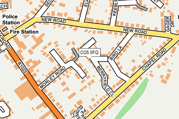
CO5 0FQ is located in the Tiptree electoral ward, within the local authority district of Colchester and the English Parliamentary constituency of Witham. The Sub Integrated Care Board (ICB) Location is NHS Suffolk and North East Essex ICB - 06T and the police force is Essex. This postcode has been in use since June 2017.


GetTheData
Source: OS OpenMap – Local (Ordnance Survey)
Source: OS VectorMap District (Ordnance Survey)
Licence: Open Government Licence (requires attribution)
| Easting | 590005 |
| Northing | 215972 |
| Latitude | 51.810093 |
| Longitude | 0.754858 |
GetTheData
Source: Open Postcode Geo
Licence: Open Government Licence
| Country | England |
| Postcode District | CO5 |
➜ See where CO5 is on a map ➜ Where is Tiptree? | |
GetTheData
Source: Land Registry Price Paid Data
Licence: Open Government Licence
| Ward | Tiptree |
| Constituency | Witham |
GetTheData
Source: ONS Postcode Database
Licence: Open Government Licence
2022 28 NOV £425,000 |
2021 5 NOV £385,000 |
2021 29 JAN £535,000 |
2018 15 JUN £475,000 |
14, BERRYFIELD CLOSE, TIPTREE, COLCHESTER, CO5 0FQ 2018 20 APR £332,450 |
24, BERRYFIELD CLOSE, TIPTREE, COLCHESTER, CO5 0FQ 2018 19 JAN £375,000 |
26, BERRYFIELD CLOSE, TIPTREE, COLCHESTER, CO5 0FQ 2017 13 DEC £379,950 |
25, BERRYFIELD CLOSE, TIPTREE, COLCHESTER, CO5 0FQ 2017 12 OCT £352,500 |
31, BERRYFIELD CLOSE, TIPTREE, COLCHESTER, CO5 0FQ 2017 30 JUN £359,950 |
2017 16 JUN £359,950 |
GetTheData
Source: HM Land Registry Price Paid Data
Licence: Contains HM Land Registry data © Crown copyright and database right 2024. This data is licensed under the Open Government Licence v3.0.
| Station Road (Church Road) | Tiptree | 223m |
| Station Road (Church Road) | Tiptree | 227m |
| The Centre (Church Road) | Tiptree | 274m |
| The Centre (Church Road) | Tiptree | 373m |
| Anchor Road (Station Road) | Tiptree | 422m |
| Kelvedon Station | 5km |
GetTheData
Source: NaPTAN
Licence: Open Government Licence
| Percentage of properties with Next Generation Access | 100.0% |
| Percentage of properties with Superfast Broadband | 100.0% |
| Percentage of properties with Ultrafast Broadband | 0.0% |
| Percentage of properties with Full Fibre Broadband | 0.0% |
Superfast Broadband is between 30Mbps and 300Mbps
Ultrafast Broadband is > 300Mbps
| Median download speed | 55.4Mbps |
| Average download speed | 47.4Mbps |
| Maximum download speed | 72.92Mbps |
| Median upload speed | 15.7Mbps |
| Average upload speed | 12.5Mbps |
| Maximum upload speed | 20.00Mbps |
| Percentage of properties unable to receive 2Mbps | 0.0% |
| Percentage of properties unable to receive 5Mbps | 0.0% |
| Percentage of properties unable to receive 10Mbps | 0.0% |
| Percentage of properties unable to receive 30Mbps | 0.0% |
GetTheData
Source: Ofcom
Licence: Ofcom Terms of Use (requires attribution)
GetTheData
Source: ONS Postcode Database
Licence: Open Government Licence


➜ Get more ratings from the Food Standards Agency
GetTheData
Source: Food Standards Agency
Licence: FSA terms & conditions
| Last Collection | |||
|---|---|---|---|
| Location | Mon-Fri | Sat | Distance |
| Tiptree Post Office | 17:15 | 12:00 | 416m |
| Tiptree Post Office | 17:15 | 12:00 | 434m |
| Anchor Road Tiptree | 17:00 | 10:30 | 486m |
GetTheData
Source: Dracos
Licence: Creative Commons Attribution-ShareAlike
The below table lists the International Territorial Level (ITL) codes (formerly Nomenclature of Territorial Units for Statistics (NUTS) codes) and Local Administrative Units (LAU) codes for CO5 0FQ:
| ITL 1 Code | Name |
|---|---|
| TLH | East |
| ITL 2 Code | Name |
| TLH3 | Essex |
| ITL 3 Code | Name |
| TLH34 | Essex Haven Gateway |
| LAU 1 Code | Name |
| E07000071 | Colchester |
GetTheData
Source: ONS Postcode Directory
Licence: Open Government Licence
The below table lists the Census Output Area (OA), Lower Layer Super Output Area (LSOA), and Middle Layer Super Output Area (MSOA) for CO5 0FQ:
| Code | Name | |
|---|---|---|
| OA | E00110342 | |
| LSOA | E01021723 | Colchester 020A |
| MSOA | E02004525 | Colchester 020 |
GetTheData
Source: ONS Postcode Directory
Licence: Open Government Licence
| CO5 0RB | Bird Lane | 85m |
| CO5 0AA | Morley Road | 103m |
| CO5 0HN | New Road | 133m |
| CO5 0RA | Chapel Road | 149m |
| CO5 0GY | Peartree Court | 179m |
| CO5 0HW | New Road | 179m |
| CO5 0RD | Chapel Road | 179m |
| CO5 0HJ | New Road | 191m |
| CO5 0AW | Church Road | 201m |
| CO5 0NU | Keeble Close | 223m |
GetTheData
Source: Open Postcode Geo; Land Registry Price Paid Data
Licence: Open Government Licence