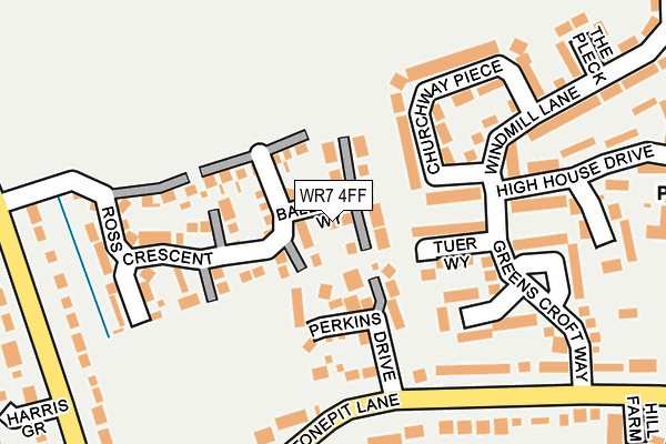
WR7 4FF is located in the Inkberrow electoral ward, within the local authority district of Wychavon and the English Parliamentary constituency of Redditch. The Sub Integrated Care Board (ICB) Location is NHS Herefordshire and Worcestershire ICB - 18C and the police force is West Mercia. This postcode has been in use since March 2017.


GetTheData
Source: OS OpenMap – Local (Ordnance Survey)
Source: OS VectorMap District (Ordnance Survey)
Licence: Open Government Licence (requires attribution)
| Easting | 401107 |
| Northing | 257336 |
| Latitude | 52.214252 |
| Longitude | -1.985209 |
GetTheData
Source: Open Postcode Geo
Licence: Open Government Licence
| Country | England |
| Postcode District | WR7 |
➜ See where WR7 is on a map ➜ Where is Inkberrow? | |
GetTheData
Source: Land Registry Price Paid Data
Licence: Open Government Licence
| Ward | Inkberrow |
| Constituency | Redditch |
GetTheData
Source: ONS Postcode Database
Licence: Open Government Licence
2024 16 OCT £399,950 |
2018 18 DEC £280,000 |
26, BALLARD WAY, INKBERROW, WORCESTER, WR7 4FF 2017 22 SEP £289,995 |
2017 22 SEP £314,995 |
28, BALLARD WAY, INKBERROW, WORCESTER, WR7 4FF 2017 22 AUG £314,995 |
1, BALLARD WAY, INKBERROW, WORCESTER, WR7 4FF 2017 30 JUN £451,246 |
3, BALLARD WAY, INKBERROW, WORCESTER, WR7 4FF 2017 30 JUN £319,995 |
2017 12 JUN £294,995 |
GetTheData
Source: HM Land Registry Price Paid Data
Licence: Contains HM Land Registry data © Crown copyright and database right 2025. This data is licensed under the Open Government Licence v3.0.
| Orchard Mead (Greens Croft Way) | Inkberrow | 178m |
| Bull's Head (High Street) | Inkberrow | 327m |
| Bull's Head (High Street) | Inkberrow | 340m |
| North Of Stonepit Lane Crossroads (Withybed Lane) | Stonepits | 346m |
| Stockwood Lane Junction (Windmill Lane) | Inkberrow | 428m |
GetTheData
Source: NaPTAN
Licence: Open Government Licence
| Percentage of properties with Next Generation Access | 100.0% |
| Percentage of properties with Superfast Broadband | 100.0% |
| Percentage of properties with Ultrafast Broadband | 0.0% |
| Percentage of properties with Full Fibre Broadband | 0.0% |
Superfast Broadband is between 30Mbps and 300Mbps
Ultrafast Broadband is > 300Mbps
| Median download speed | 21.3Mbps |
| Average download speed | 31.7Mbps |
| Maximum download speed | 65.68Mbps |
| Median upload speed | 1.2Mbps |
| Average upload speed | 5.5Mbps |
| Maximum upload speed | 17.69Mbps |
| Percentage of properties unable to receive 2Mbps | 0.0% |
| Percentage of properties unable to receive 5Mbps | 0.0% |
| Percentage of properties unable to receive 10Mbps | 0.0% |
| Percentage of properties unable to receive 30Mbps | 0.0% |
GetTheData
Source: Ofcom
Licence: Ofcom Terms of Use (requires attribution)
GetTheData
Source: ONS Postcode Database
Licence: Open Government Licence

➜ Get more ratings from the Food Standards Agency
GetTheData
Source: Food Standards Agency
Licence: FSA terms & conditions
| Last Collection | |||
|---|---|---|---|
| Location | Mon-Fri | Sat | Distance |
| High House Drive | 16:45 | 10:30 | 144m |
| Stonepits | 16:45 | 11:00 | 273m |
| Inkberrow P.o. | 16:45 | 11:00 | 515m |
GetTheData
Source: Dracos
Licence: Creative Commons Attribution-ShareAlike
The below table lists the International Territorial Level (ITL) codes (formerly Nomenclature of Territorial Units for Statistics (NUTS) codes) and Local Administrative Units (LAU) codes for WR7 4FF:
| ITL 1 Code | Name |
|---|---|
| TLG | West Midlands (England) |
| ITL 2 Code | Name |
| TLG1 | Herefordshire, Worcestershire and Warwickshire |
| ITL 3 Code | Name |
| TLG12 | Worcestershire CC |
| LAU 1 Code | Name |
| E07000238 | Wychavon |
GetTheData
Source: ONS Postcode Directory
Licence: Open Government Licence
The below table lists the Census Output Area (OA), Lower Layer Super Output Area (LSOA), and Middle Layer Super Output Area (MSOA) for WR7 4FF:
| Code | Name | |
|---|---|---|
| OA | E00165218 | |
| LSOA | E01032393 | Wychavon 008B |
| MSOA | E02006755 | Wychavon 008 |
GetTheData
Source: ONS Postcode Directory
Licence: Open Government Licence
| WR7 4EQ | Tuer Way | 87m |
| WR7 4HB | Churchway Piece | 125m |
| WR7 4EH | Orchard Mead | 161m |
| WR7 4ED | Stonepit Lane | 199m |
| WR7 4EE | Greenscroft Way | 206m |
| WR7 4EF | Malt House Crescent | 207m |
| WR7 4EG | High House Drive | 239m |
| WR7 4JB | The Pleck | 247m |
| WR7 4JJ | Withybed Lane | 270m |
| WR7 4HG | Windmill Lane | 294m |
GetTheData
Source: Open Postcode Geo; Land Registry Price Paid Data
Licence: Open Government Licence