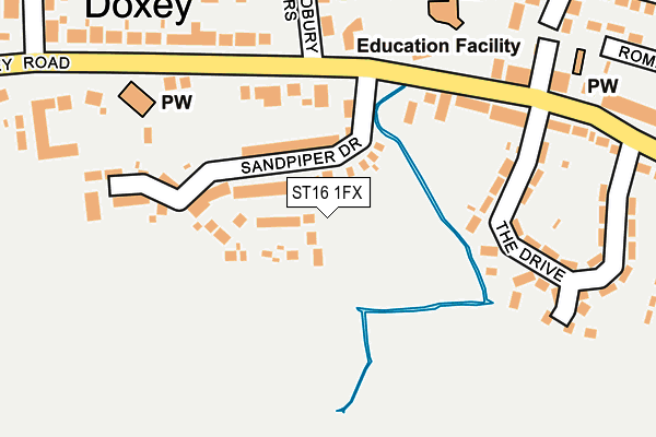
ST16 1FX is located in the Doxey & Castletown electoral ward, within the local authority district of Stafford and the English Parliamentary constituency of Stafford. The Sub Integrated Care Board (ICB) Location is NHS Staffordshire and Stoke-on-Trent ICB - 05V and the police force is Staffordshire. This postcode has been in use since April 2017.


GetTheData
Source: OS OpenMap – Local (Ordnance Survey)
Source: OS VectorMap District (Ordnance Survey)
Licence: Open Government Licence (requires attribution)
| Easting | 390396 |
| Northing | 323572 |
| Latitude | 52.809624 |
| Longitude | -2.143916 |
GetTheData
Source: Open Postcode Geo
Licence: Open Government Licence
| Country | England |
| Postcode District | ST16 |
➜ See where ST16 is on a map ➜ Where is Stafford? | |
GetTheData
Source: Land Registry Price Paid Data
Licence: Open Government Licence
| Ward | Doxey & Castletown |
| Constituency | Stafford |
GetTheData
Source: ONS Postcode Database
Licence: Open Government Licence
2021 24 SEP £340,000 |
2021 5 MAR £335,000 |
16, LAPWING PLACE, STAFFORD, ST16 1FX 2020 29 MAY £347,495 |
19, LAPWING PLACE, STAFFORD, ST16 1FX 2019 6 DEC £308,750 |
23, LAPWING PLACE, STAFFORD, ST16 1FX 2019 26 JUL £334,500 |
21, LAPWING PLACE, STAFFORD, ST16 1FX 2019 24 MAY £344,500 |
26, LAPWING PLACE, STAFFORD, ST16 1FX 2019 10 MAY £308,750 |
2019 9 APR £303,995 |
25, LAPWING PLACE, STAFFORD, ST16 1FX 2019 5 APR £350,995 |
2019 31 JAN £318,694 |
GetTheData
Source: HM Land Registry Price Paid Data
Licence: Contains HM Land Registry data © Crown copyright and database right 2024. This data is licensed under the Open Government Licence v3.0.
| Three Tuns Ph (Doxey Rd) | Doxey | 173m |
| Three Tuns Ph (Doxey Rd) | Doxey | 182m |
| The Drive (Doxey Road) | Doxey | 241m |
| The Drive (Doxey Road) | Doxey | 244m |
| Marsland Road (Greensome Lane) | Doxey | 289m |
| Stafford Station | 1.6km |
GetTheData
Source: NaPTAN
Licence: Open Government Licence
| Percentage of properties with Next Generation Access | 100.0% |
| Percentage of properties with Superfast Broadband | 100.0% |
| Percentage of properties with Ultrafast Broadband | 0.0% |
| Percentage of properties with Full Fibre Broadband | 0.0% |
Superfast Broadband is between 30Mbps and 300Mbps
Ultrafast Broadband is > 300Mbps
| Median download speed | 39.1Mbps |
| Average download speed | 42.4Mbps |
| Maximum download speed | 78.12Mbps |
| Median upload speed | 9.8Mbps |
| Average upload speed | 11.4Mbps |
| Maximum upload speed | 20.00Mbps |
| Percentage of properties unable to receive 2Mbps | 0.0% |
| Percentage of properties unable to receive 5Mbps | 0.0% |
| Percentage of properties unable to receive 10Mbps | 0.0% |
| Percentage of properties unable to receive 30Mbps | 0.0% |
GetTheData
Source: Ofcom
Licence: Ofcom Terms of Use (requires attribution)
GetTheData
Source: ONS Postcode Database
Licence: Open Government Licence


➜ Get more ratings from the Food Standards Agency
GetTheData
Source: Food Standards Agency
Licence: FSA terms & conditions
| Last Collection | |||
|---|---|---|---|
| Location | Mon-Fri | Sat | Distance |
| Doxey Post Office | 17:30 | 11:15 | 221m |
| The Drive | 17:30 | 11:15 | 280m |
| Greensome Lane | 17:30 | 11:15 | 589m |
GetTheData
Source: Dracos
Licence: Creative Commons Attribution-ShareAlike
| Risk of ST16 1FX flooding from rivers and sea | Low |
| ➜ ST16 1FX flood map | |
GetTheData
Source: Open Flood Risk by Postcode
Licence: Open Government Licence
The below table lists the International Territorial Level (ITL) codes (formerly Nomenclature of Territorial Units for Statistics (NUTS) codes) and Local Administrative Units (LAU) codes for ST16 1FX:
| ITL 1 Code | Name |
|---|---|
| TLG | West Midlands (England) |
| ITL 2 Code | Name |
| TLG2 | Shropshire and Staffordshire |
| ITL 3 Code | Name |
| TLG24 | Staffordshire CC |
| LAU 1 Code | Name |
| E07000197 | Stafford |
GetTheData
Source: ONS Postcode Directory
Licence: Open Government Licence
The below table lists the Census Output Area (OA), Lower Layer Super Output Area (LSOA), and Middle Layer Super Output Area (MSOA) for ST16 1FX:
| Code | Name | |
|---|---|---|
| OA | E00151593 | |
| LSOA | E01029750 | Stafford 007D |
| MSOA | E02006194 | Stafford 007 |
GetTheData
Source: ONS Postcode Directory
Licence: Open Government Licence
| ST16 1EG | Doxey | 199m |
| ST16 1EF | The Drive | 232m |
| ST16 1EL | Bradbury Rise | 254m |
| ST16 1EQ | Doxey | 263m |
| ST16 1XE | Walland Grove | 287m |
| ST16 1EN | Conway Road | 295m |
| ST16 1HW | Marsland Close | 331m |
| ST16 1EW | Conway Road | 341m |
| ST16 1XD | Romney Drive | 343m |
| ST16 1EE | Doxey | 374m |
GetTheData
Source: Open Postcode Geo; Land Registry Price Paid Data
Licence: Open Government Licence