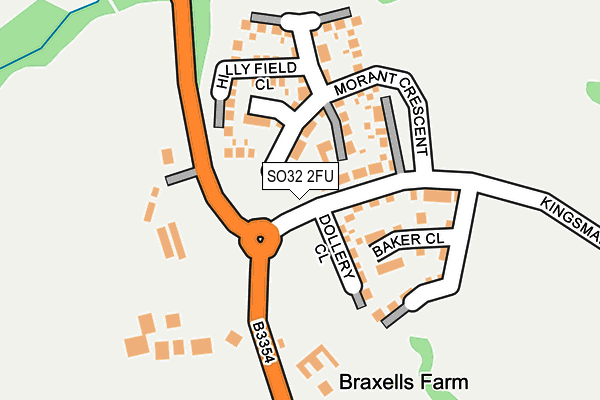
SO32 2FU is located in the Botley electoral ward, within the local authority district of Eastleigh and the English Parliamentary constituency of Eastleigh. The Sub Integrated Care Board (ICB) Location is NHS Hampshire and Isle of Wight ICB - D9Y0V and the police force is Hampshire. This postcode has been in use since April 2017.


GetTheData
Source: OS OpenMap – Local (Ordnance Survey)
Source: OS VectorMap District (Ordnance Survey)
Licence: Open Government Licence (requires attribution)
| Easting | 450511 |
| Northing | 115162 |
| Latitude | 50.933694 |
| Longitude | -1.282560 |
GetTheData
Source: Open Postcode Geo
Licence: Open Government Licence
| Country | England |
| Postcode District | SO32 |
➜ See where SO32 is on a map ➜ Where is Boorley Green? | |
GetTheData
Source: Land Registry Price Paid Data
Licence: Open Government Licence
| Ward | Botley |
| Constituency | Eastleigh |
GetTheData
Source: ONS Postcode Database
Licence: Open Government Licence
2024 7 AUG £490,000 |
2022 9 FEB £420,000 |
2021 23 FEB £475,000 |
1, DOLLERY CLOSE, BOTLEY, SOUTHAMPTON, SO32 2FU 2020 18 JAN £505,000 |
2017 30 JUN £505,000 |
2017 30 JUN £399,950 |
5, DOLLERY CLOSE, BOTLEY, SOUTHAMPTON, SO32 2FU 2017 1 JUN £379,950 |
4, DOLLERY CLOSE, BOTLEY, SOUTHAMPTON, SO32 2FU 2017 24 MAY £589,950 |
GetTheData
Source: HM Land Registry Price Paid Data
Licence: Contains HM Land Registry data © Crown copyright and database right 2025. This data is licensed under the Open Government Licence v3.0.
| Braxells Farm (Winchester Road) | Long Common | 130m |
| Braxells Farm (Winchester Road) | Long Common | 146m |
| Chancellors Lane (Winchester Road) | Long Common | 361m |
| Chancellors Lane (Winchester Road) | Long Common | 385m |
| Pear Tree (Winchester Road) | Boorley Green | 559m |
| Hedge End Station | 0.9km |
| Botley Station | 2.5km |
| Eastleigh Station | 6.2km |
GetTheData
Source: NaPTAN
Licence: Open Government Licence
| Percentage of properties with Next Generation Access | 100.0% |
| Percentage of properties with Superfast Broadband | 100.0% |
| Percentage of properties with Ultrafast Broadband | 100.0% |
| Percentage of properties with Full Fibre Broadband | 100.0% |
Superfast Broadband is between 30Mbps and 300Mbps
Ultrafast Broadband is > 300Mbps
| Percentage of properties unable to receive 2Mbps | 0.0% |
| Percentage of properties unable to receive 5Mbps | 0.0% |
| Percentage of properties unable to receive 10Mbps | 0.0% |
| Percentage of properties unable to receive 30Mbps | 0.0% |
GetTheData
Source: Ofcom
Licence: Ofcom Terms of Use (requires attribution)
GetTheData
Source: ONS Postcode Database
Licence: Open Government Licence


➜ Get more ratings from the Food Standards Agency
GetTheData
Source: Food Standards Agency
Licence: FSA terms & conditions
| Last Collection | |||
|---|---|---|---|
| Location | Mon-Fri | Sat | Distance |
| Boorley Green | 16:00 | 08:15 | 868m |
| Beattie Rise | 16:30 | 07:45 | 940m |
| Maunsell Way | 16:30 | 08:00 | 1,161m |
GetTheData
Source: Dracos
Licence: Creative Commons Attribution-ShareAlike
The below table lists the International Territorial Level (ITL) codes (formerly Nomenclature of Territorial Units for Statistics (NUTS) codes) and Local Administrative Units (LAU) codes for SO32 2FU:
| ITL 1 Code | Name |
|---|---|
| TLJ | South East (England) |
| ITL 2 Code | Name |
| TLJ3 | Hampshire and Isle of Wight |
| ITL 3 Code | Name |
| TLJ35 | South Hampshire |
| LAU 1 Code | Name |
| E07000086 | Eastleigh |
GetTheData
Source: ONS Postcode Directory
Licence: Open Government Licence
The below table lists the Census Output Area (OA), Lower Layer Super Output Area (LSOA), and Middle Layer Super Output Area (MSOA) for SO32 2FU:
| Code | Name | |
|---|---|---|
| OA | E00115146 | |
| LSOA | E01022653 | Eastleigh 010A |
| MSOA | E02004721 | Eastleigh 010 |
GetTheData
Source: ONS Postcode Directory
Licence: Open Government Licence
| SO32 2DH | Winchester Road | 589m |
| SO32 2RR | Pear Tree Close | 618m |
| SO32 2EQ | Orchard Close | 655m |
| SO32 2DG | Maddoxford Lane | 661m |
| SO32 2BX | Winchester Road | 695m |
| SO32 2DW | Maddoxford Way | 697m |
| SO32 2EN | Oatlands Close | 715m |
| SO30 2TE | Ardingly Crescent | 730m |
| SO30 2TQ | Telford Gardens | 734m |
| SO30 2TG | Telford Gardens | 759m |
GetTheData
Source: Open Postcode Geo; Land Registry Price Paid Data
Licence: Open Government Licence