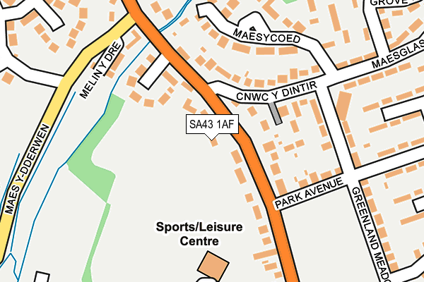
SA43 1AF lies on Gwbert Road in Cardigan. SA43 1AF is located in the Mwldan electoral ward, within the unitary authority of Ceredigion and the Welsh Parliamentary constituency of Ceredigion. The Local Health Board is Hywel Dda University and the police force is Dyfed-Powys. This postcode has been in use since January 1980.


GetTheData
Source: OS OpenMap – Local (Ordnance Survey)
Source: OS VectorMap District (Ordnance Survey)
Licence: Open Government Licence (requires attribution)
| Easting | 218088 |
| Northing | 246882 |
| Latitude | 52.090306 |
| Longitude | -4.656740 |
GetTheData
Source: Open Postcode Geo
Licence: Open Government Licence
| Street | Gwbert Road |
| Town/City | Cardigan |
| Country | Wales |
| Postcode District | SA43 |
➜ See where SA43 is on a map ➜ Where is Cardigan? | |
GetTheData
Source: Land Registry Price Paid Data
Licence: Open Government Licence
Elevation or altitude of SA43 1AF as distance above sea level:
| Metres | Feet | |
|---|---|---|
| Elevation | 20m | 66ft |
Elevation is measured from the approximate centre of the postcode, to the nearest point on an OS contour line from OS Terrain 50, which has contour spacing of ten vertical metres.
➜ How high above sea level am I? Find the elevation of your current position using your device's GPS.
GetTheData
Source: Open Postcode Elevation
Licence: Open Government Licence
| Ward | Mwldan |
| Constituency | Ceredigion |
GetTheData
Source: ONS Postcode Database
Licence: Open Government Licence
2023 6 JUL £485,000 |
2023 16 MAR £482,000 |
CAERMARIA, GWBERT ROAD, CARDIGAN, SA43 1AF 2022 14 SEP £395,750 |
PANT-YR-HAUL, GWBERT ROAD, CARDIGAN, SA43 1AF 2021 1 JUN £290,000 |
CAER Y GLYN, GWBERT ROAD, CARDIGAN, SA43 1AF 2018 7 DEC £340,000 |
TREWADDON, GWBERT ROAD, CARDIGAN, SA43 1AF 2017 19 DEC £193,000 |
PANT-YR-HAUL, GWBERT ROAD, CARDIGAN, SA43 1AF 2013 19 NOV £250,000 |
PANT-YR-HAUL, GWBERT ROAD, CARDIGAN, SA43 1AF 2009 16 OCT £245,000 |
HENDREWEN, GWBERT ROAD, CARDIGAN, SA43 1AF 2007 31 MAY £245,000 |
2006 17 MAY £299,000 |
GetTheData
Source: HM Land Registry Price Paid Data
Licence: Contains HM Land Registry data © Crown copyright and database right 2025. This data is licensed under the Open Government Licence v3.0.
| Hawthorns (Maesglas) | Cardigan | 197m |
| Hawthorns (Maesglas) | Cardigan | 200m |
| Melin-y-dre (Gwbert Road) | Cardigan | 226m |
| Maesglas Estate (Maesglas) | Cardigan | 355m |
| Secondary School (Grounds) | Cardigan | 362m |
GetTheData
Source: NaPTAN
Licence: Open Government Licence
| Percentage of properties with Next Generation Access | 100.0% |
| Percentage of properties with Superfast Broadband | 100.0% |
| Percentage of properties with Ultrafast Broadband | 5.3% |
| Percentage of properties with Full Fibre Broadband | 5.3% |
Superfast Broadband is between 30Mbps and 300Mbps
Ultrafast Broadband is > 300Mbps
| Median download speed | 32.3Mbps |
| Average download speed | 35.9Mbps |
| Maximum download speed | 78.12Mbps |
| Median upload speed | 4.9Mbps |
| Average upload speed | 6.8Mbps |
| Maximum upload speed | 20.00Mbps |
| Percentage of properties unable to receive 2Mbps | 0.0% |
| Percentage of properties unable to receive 5Mbps | 0.0% |
| Percentage of properties unable to receive 10Mbps | 0.0% |
| Percentage of properties unable to receive 30Mbps | 0.0% |
GetTheData
Source: Ofcom
Licence: Ofcom Terms of Use (requires attribution)
Estimated total energy consumption in SA43 1AF by fuel type, 2015.
| Consumption (kWh) | 629,980 |
|---|---|
| Meter count | 25 |
| Mean (kWh/meter) | 25,199 |
| Median (kWh/meter) | 24,565 |
| Consumption (kWh) | 86,190 |
|---|---|
| Meter count | 19 |
| Mean (kWh/meter) | 4,536 |
| Median (kWh/meter) | 3,614 |
GetTheData
Source: Postcode level gas estimates: 2015 (experimental)
Source: Postcode level electricity estimates: 2015 (experimental)
Licence: Open Government Licence
GetTheData
Source: ONS Postcode Database
Licence: Open Government Licence


➜ Get more ratings from the Food Standards Agency
GetTheData
Source: Food Standards Agency
Licence: FSA terms & conditions
| Last Collection | |||
|---|---|---|---|
| Location | Mon-Fri | Sat | Distance |
| Feidr Fair (Mapstone) | 16:30 | 12:30 | 584m |
| Tesco | 16:00 | 12:00 | 623m |
| Cardigan Delivery Office | 17:15 | 13:00 | 1,097m |
GetTheData
Source: Dracos
Licence: Creative Commons Attribution-ShareAlike
The below table lists the International Territorial Level (ITL) codes (formerly Nomenclature of Territorial Units for Statistics (NUTS) codes) and Local Administrative Units (LAU) codes for SA43 1AF:
| ITL 1 Code | Name |
|---|---|
| TLL | Wales |
| ITL 2 Code | Name |
| TLL1 | West Wales and The Valleys |
| ITL 3 Code | Name |
| TLL14 | South West Wales |
| LAU 1 Code | Name |
| W06000008 | Ceredigion |
GetTheData
Source: ONS Postcode Directory
Licence: Open Government Licence
The below table lists the Census Output Area (OA), Lower Layer Super Output Area (LSOA), and Middle Layer Super Output Area (MSOA) for SA43 1AF:
| Code | Name | |
|---|---|---|
| OA | W00002719 | |
| LSOA | W01000509 | Ceredigion 009C |
| MSOA | W02000124 | Ceredigion 009 |
GetTheData
Source: ONS Postcode Directory
Licence: Open Government Licence
| SA43 1AW | Cnwc Y Dintir | 117m |
| SA43 1EN | Clos Llyn Y Felin | 127m |
| SA43 1AL | Gwbert Road | 139m |
| SA43 1AG | Park Avenue | 156m |
| SA43 1AP | Maes Y Coed | 181m |
| SA43 1AQ | Maesglas | 187m |
| SA43 1AH | Greenland Meadows | 203m |
| SA43 1AE | Park Place | 211m |
| SA43 1AT | Maesglas | 237m |
| SA43 1AU | Rhyd Y Felin | 248m |
GetTheData
Source: Open Postcode Geo; Land Registry Price Paid Data
Licence: Open Government Licence