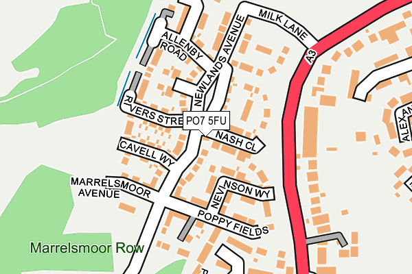
PO7 5FU is located in the Stakes electoral ward, within the local authority district of Havant and the English Parliamentary constituency of Havant. The Sub Integrated Care Board (ICB) Location is NHS Hampshire and Isle of Wight ICB - D9Y0V and the police force is Hampshire. This postcode has been in use since May 2017.


GetTheData
Source: OS OpenMap – Local (Ordnance Survey)
Source: OS VectorMap District (Ordnance Survey)
Licence: Open Government Licence (requires attribution)
| Easting | 467291 |
| Northing | 108467 |
| Latitude | 50.871786 |
| Longitude | -1.045029 |
GetTheData
Source: Open Postcode Geo
Licence: Open Government Licence
| Country | England |
| Postcode District | PO7 |
➜ See where PO7 is on a map ➜ Where is Purbrook? | |
GetTheData
Source: Land Registry Price Paid Data
Licence: Open Government Licence
| Ward | Stakes |
| Constituency | Havant |
GetTheData
Source: ONS Postcode Database
Licence: Open Government Licence
2022 30 AUG £520,000 |
2020 23 JAN £367,500 |
2018 12 JAN £375,950 |
2017 15 DEC £357,950 |
14, NASH CLOSE, WATERLOOVILLE, PO7 5FU 2017 22 NOV £371,950 |
16, NASH CLOSE, WATERLOOVILLE, PO7 5FU 2017 22 NOV £353,950 |
1, NASH CLOSE, WATERLOOVILLE, PO7 5FU 2017 21 JUL £439,950 |
2, NASH CLOSE, WATERLOOVILLE, PO7 5FU 2017 23 JUN £469,950 |
4, NASH CLOSE, WATERLOOVILLE, PO7 5FU 2017 23 JUN £379,950 |
GetTheData
Source: HM Land Registry Price Paid Data
Licence: Contains HM Land Registry data © Crown copyright and database right 2025. This data is licensed under the Open Government Licence v3.0.
| Berewood (London Road) | Waterlooville | 110m |
| Campbell Crescent (London Road) | Purbrook | 254m |
| Campbell Crescent (London Road) | Purbrook | 267m |
| Corbett Road (London Road) | Waterlooville | 353m |
| Corbett Road (London Road) | Waterlooville | 365m |
| Cosham Station | 3.7km |
| Bedhampton Station | 4km |
| Havant Station | 4.9km |
GetTheData
Source: NaPTAN
Licence: Open Government Licence
| Percentage of properties with Next Generation Access | 100.0% |
| Percentage of properties with Superfast Broadband | 100.0% |
| Percentage of properties with Ultrafast Broadband | 100.0% |
| Percentage of properties with Full Fibre Broadband | 100.0% |
Superfast Broadband is between 30Mbps and 300Mbps
Ultrafast Broadband is > 300Mbps
| Percentage of properties unable to receive 2Mbps | 0.0% |
| Percentage of properties unable to receive 5Mbps | 0.0% |
| Percentage of properties unable to receive 10Mbps | 0.0% |
| Percentage of properties unable to receive 30Mbps | 0.0% |
GetTheData
Source: Ofcom
Licence: Ofcom Terms of Use (requires attribution)
GetTheData
Source: ONS Postcode Database
Licence: Open Government Licence


➜ Get more ratings from the Food Standards Agency
GetTheData
Source: Food Standards Agency
Licence: FSA terms & conditions
| Last Collection | |||
|---|---|---|---|
| Location | Mon-Fri | Sat | Distance |
| Deverall Hall | 16:45 | 11:50 | 243m |
| Stakes Road Shops | 16:00 | 11:45 | 537m |
| Gordon Road | 16:15 | 11:40 | 542m |
GetTheData
Source: Dracos
Licence: Creative Commons Attribution-ShareAlike
The below table lists the International Territorial Level (ITL) codes (formerly Nomenclature of Territorial Units for Statistics (NUTS) codes) and Local Administrative Units (LAU) codes for PO7 5FU:
| ITL 1 Code | Name |
|---|---|
| TLJ | South East (England) |
| ITL 2 Code | Name |
| TLJ3 | Hampshire and Isle of Wight |
| ITL 3 Code | Name |
| TLJ35 | South Hampshire |
| LAU 1 Code | Name |
| E07000090 | Havant |
GetTheData
Source: ONS Postcode Directory
Licence: Open Government Licence
The below table lists the Census Output Area (OA), Lower Layer Super Output Area (LSOA), and Middle Layer Super Output Area (MSOA) for PO7 5FU:
| Code | Name | |
|---|---|---|
| OA | E00116675 | |
| LSOA | E01022962 | Havant 005B |
| MSOA | E02004766 | Havant 005 |
GetTheData
Source: ONS Postcode Directory
Licence: Open Government Licence
| PO7 5FH | Newlands Avenue | 40m |
| PO7 5FS | Lawrence Place | 122m |
| PO7 5FR | Rivers Street | 130m |
| PO7 5SU | London Road | 133m |
| PO7 5FL | Allenby Road | 151m |
| PO7 5JU | London Road | 171m |
| PO7 5SY | Waterside Gardens | 175m |
| PO7 5FN | Trenchard Close | 177m |
| PO7 5LE | Purbrook Gardens | 199m |
| PO7 5LF | London Road | 223m |
GetTheData
Source: Open Postcode Geo; Land Registry Price Paid Data
Licence: Open Government Licence