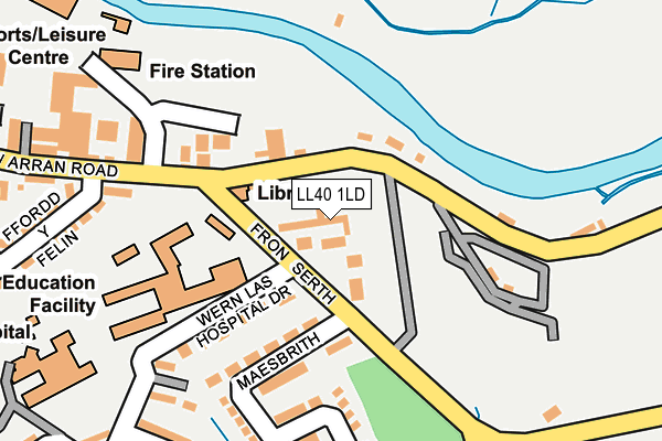
LL40 1LD lies on Arran Road in Dolgellau. LL40 1LD is located in the De Dolgellau electoral ward, within the unitary authority of Gwynedd and the Welsh Parliamentary constituency of Dwyfor Meirionnydd. The Local Health Board is Betsi Cadwaladr University and the police force is North Wales. This postcode has been in use since August 1993.


GetTheData
Source: OS OpenMap – Local (Ordnance Survey)
Source: OS VectorMap District (Ordnance Survey)
Licence: Open Government Licence (requires attribution)
| Easting | 273316 |
| Northing | 317701 |
| Latitude | 52.742061 |
| Longitude | -3.878012 |
GetTheData
Source: Open Postcode Geo
Licence: Open Government Licence
| Street | Arran Road |
| Town/City | Dolgellau |
| Country | Wales |
| Postcode District | LL40 |
➜ See where LL40 is on a map ➜ Where is Dolgellau? | |
GetTheData
Source: Land Registry Price Paid Data
Licence: Open Government Licence
Elevation or altitude of LL40 1LD as distance above sea level:
| Metres | Feet | |
|---|---|---|
| Elevation | 20m | 66ft |
Elevation is measured from the approximate centre of the postcode, to the nearest point on an OS contour line from OS Terrain 50, which has contour spacing of ten vertical metres.
➜ How high above sea level am I? Find the elevation of your current position using your device's GPS.
GetTheData
Source: Open Postcode Elevation
Licence: Open Government Licence
| Ward | De Dolgellau |
| Constituency | Dwyfor Meirionnydd |
GetTheData
Source: ONS Postcode Database
Licence: Open Government Licence
2024 25 OCT £325,000 |
2021 31 AUG £241,220 |
2020 30 JUN £246,000 |
2019 15 AUG £240,000 |
12, LLWYN VIEW, FRON SERTH, DOLGELLAU, LL40 1LD 2006 21 DEC £166,500 |
2005 22 JUL £184,000 |
GetTheData
Source: HM Land Registry Price Paid Data
Licence: Contains HM Land Registry data © Crown copyright and database right 2025. This data is licensed under the Open Government Licence v3.0.
| Ysgol Y Gader (Arran Road) | Dolgellau | 139m |
| Ffordd Arran Road (Arran Road) | Dolgellau | 153m |
| Ysgol Y Gader (Arran Road) | Dolgellau | 159m |
| Hospital (Hospital Drive) | Dolgellau | 223m |
| Penycaeau (Wern Las) | Dolgellau | 449m |
GetTheData
Source: NaPTAN
Licence: Open Government Licence
| Percentage of properties with Next Generation Access | 100.0% |
| Percentage of properties with Superfast Broadband | 100.0% |
| Percentage of properties with Ultrafast Broadband | 100.0% |
| Percentage of properties with Full Fibre Broadband | 100.0% |
Superfast Broadband is between 30Mbps and 300Mbps
Ultrafast Broadband is > 300Mbps
| Median download speed | 21.6Mbps |
| Average download speed | 19.8Mbps |
| Maximum download speed | 22.47Mbps |
| Median upload speed | 1.2Mbps |
| Average upload speed | 1.2Mbps |
| Maximum upload speed | 1.29Mbps |
| Percentage of properties unable to receive 2Mbps | 0.0% |
| Percentage of properties unable to receive 5Mbps | 0.0% |
| Percentage of properties unable to receive 10Mbps | 0.0% |
| Percentage of properties unable to receive 30Mbps | 0.0% |
GetTheData
Source: Ofcom
Licence: Ofcom Terms of Use (requires attribution)
Estimated total energy consumption in LL40 1LD by fuel type, 2015.
| Consumption (kWh) | 110,929 |
|---|---|
| Meter count | 14 |
| Mean (kWh/meter) | 7,923 |
| Median (kWh/meter) | 7,306 |
| Consumption (kWh) | 33,030 |
|---|---|
| Meter count | 14 |
| Mean (kWh/meter) | 2,359 |
| Median (kWh/meter) | 2,138 |
GetTheData
Source: Postcode level gas estimates: 2015 (experimental)
Source: Postcode level electricity estimates: 2015 (experimental)
Licence: Open Government Licence
GetTheData
Source: ONS Postcode Database
Licence: Open Government Licence


➜ Get more ratings from the Food Standards Agency
GetTheData
Source: Food Standards Agency
Licence: FSA terms & conditions
| Last Collection | |||
|---|---|---|---|
| Location | Mon-Fri | Sat | Distance |
| Ysgol Brithdir | 17:00 | 10:45 | 2,929m |
| Brithdir | 16:45 | 10:45 | 3,891m |
| Dolserau Terrace | 16:45 | 09:45 | 4,312m |
GetTheData
Source: Dracos
Licence: Creative Commons Attribution-ShareAlike
The below table lists the International Territorial Level (ITL) codes (formerly Nomenclature of Territorial Units for Statistics (NUTS) codes) and Local Administrative Units (LAU) codes for LL40 1LD:
| ITL 1 Code | Name |
|---|---|
| TLL | Wales |
| ITL 2 Code | Name |
| TLL1 | West Wales and The Valleys |
| ITL 3 Code | Name |
| TLL12 | Gwynedd |
| LAU 1 Code | Name |
| W06000002 | Gwynedd |
GetTheData
Source: ONS Postcode Directory
Licence: Open Government Licence
The below table lists the Census Output Area (OA), Lower Layer Super Output Area (LSOA), and Middle Layer Super Output Area (MSOA) for LL40 1LD:
| Code | Name | |
|---|---|---|
| OA | W00000346 | |
| LSOA | W01000068 | Gwynedd 016E |
| MSOA | W02000025 | Gwynedd 016 |
GetTheData
Source: ONS Postcode Directory
Licence: Open Government Licence
| LL40 1LA | Arran Road | 83m |
| LL40 1PL | Hospital Drive | 121m |
| LL40 2AA | 158m | |
| LL40 1LF | Maesbrith | 176m |
| LL40 1PH | Hospital Drive | 217m |
| LL40 1HS | Arran Road | 239m |
| LL40 1PG | Gwern Lafant | 246m |
| LL40 1PF | Gwern Fedw | 271m |
| LL40 1HU | Ffordd Y Felin | 276m |
| LL40 1HR | Maes Talaran | 283m |
GetTheData
Source: Open Postcode Geo; Land Registry Price Paid Data
Licence: Open Government Licence