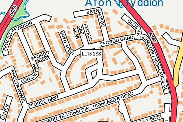
LL18 2SS lies on Nant Close in Rhuddlan, Rhyl. LL18 2SS is located in the Rhuddlan electoral ward, within the unitary authority of Denbighshire and the Welsh Parliamentary constituency of Vale of Clwyd. The Local Health Board is Betsi Cadwaladr University and the police force is North Wales. This postcode has been in use since January 1980.


GetTheData
Source: OS OpenMap – Local (Ordnance Survey)
Source: OS VectorMap District (Ordnance Survey)
Licence: Open Government Licence (requires attribution)
| Easting | 302556 |
| Northing | 378828 |
| Latitude | 53.297414 |
| Longitude | -3.463526 |
GetTheData
Source: Open Postcode Geo
Licence: Open Government Licence
| Street | Nant Close |
| Locality | Rhuddlan |
| Town/City | Rhyl |
| Country | Wales |
| Postcode District | LL18 |
➜ See where LL18 is on a map ➜ Where is Rhuddlan? | |
GetTheData
Source: Land Registry Price Paid Data
Licence: Open Government Licence
Elevation or altitude of LL18 2SS as distance above sea level:
| Metres | Feet | |
|---|---|---|
| Elevation | 10m | 33ft |
Elevation is measured from the approximate centre of the postcode, to the nearest point on an OS contour line from OS Terrain 50, which has contour spacing of ten vertical metres.
➜ How high above sea level am I? Find the elevation of your current position using your device's GPS.
GetTheData
Source: Open Postcode Elevation
Licence: Open Government Licence
| Ward | Rhuddlan |
| Constituency | Vale Of Clwyd |
GetTheData
Source: ONS Postcode Database
Licence: Open Government Licence
2024 23 AUG £310,000 |
2017 22 SEP £175,000 |
2016 14 MAR £147,000 |
2007 17 AUG £187,500 |
1, NANT CLOSE, RHUDDLAN, RHYL, LL18 2SS 2005 14 NOV £161,000 |
17, NANT CLOSE, RHUDDLAN, RHYL, LL18 2SS 1997 24 OCT £69,950 |
1997 21 AUG £69,500 |
GetTheData
Source: HM Land Registry Price Paid Data
Licence: Contains HM Land Registry data © Crown copyright and database right 2025. This data is licensed under the Open Government Licence v3.0.
| Highland Close (Fairlands Crescent) | Rhuddlan | 229m |
| Maes Y Bryn (A547) | Pen-y-ffordd | 308m |
| Bryn Cwybr (A547) | Rhuddlan | 328m |
| Bryn Cwybr (A547) | Rhuddlan | 334m |
| Haulfre (Rhyl Road) | Pen-y-ffordd | 408m |
| Rhyl Station | 2.9km |
| Prestatyn Station | 5.7km |
GetTheData
Source: NaPTAN
Licence: Open Government Licence
| Percentage of properties with Next Generation Access | 100.0% |
| Percentage of properties with Superfast Broadband | 100.0% |
| Percentage of properties with Ultrafast Broadband | 0.0% |
| Percentage of properties with Full Fibre Broadband | 0.0% |
Superfast Broadband is between 30Mbps and 300Mbps
Ultrafast Broadband is > 300Mbps
| Median download speed | 40.0Mbps |
| Average download speed | 42.6Mbps |
| Maximum download speed | 78.13Mbps |
| Median upload speed | 10.0Mbps |
| Average upload speed | 9.9Mbps |
| Maximum upload speed | 19.53Mbps |
| Percentage of properties unable to receive 2Mbps | 0.0% |
| Percentage of properties unable to receive 5Mbps | 0.0% |
| Percentage of properties unable to receive 10Mbps | 0.0% |
| Percentage of properties unable to receive 30Mbps | 0.0% |
GetTheData
Source: Ofcom
Licence: Ofcom Terms of Use (requires attribution)
Estimated total energy consumption in LL18 2SS by fuel type, 2015.
| Consumption (kWh) | 190,846 |
|---|---|
| Meter count | 14 |
| Mean (kWh/meter) | 13,632 |
| Median (kWh/meter) | 13,691 |
| Consumption (kWh) | 35,436 |
|---|---|
| Meter count | 13 |
| Mean (kWh/meter) | 2,726 |
| Median (kWh/meter) | 2,934 |
GetTheData
Source: Postcode level gas estimates: 2015 (experimental)
Source: Postcode level electricity estimates: 2015 (experimental)
Licence: Open Government Licence
GetTheData
Source: ONS Postcode Database
Licence: Open Government Licence


➜ Get more ratings from the Food Standards Agency
GetTheData
Source: Food Standards Agency
Licence: FSA terms & conditions
| Last Collection | |||
|---|---|---|---|
| Location | Mon-Fri | Sat | Distance |
| St Margarets Drive | 17:15 | 11:00 | 376m |
| Cwm Road | 17:15 | 09:00 | 3,160m |
| Dyserth Post Office | 17:20 | 11:00 | 3,342m |
GetTheData
Source: Dracos
Licence: Creative Commons Attribution-ShareAlike
The below table lists the International Territorial Level (ITL) codes (formerly Nomenclature of Territorial Units for Statistics (NUTS) codes) and Local Administrative Units (LAU) codes for LL18 2SS:
| ITL 1 Code | Name |
|---|---|
| TLL | Wales |
| ITL 2 Code | Name |
| TLL1 | West Wales and The Valleys |
| ITL 3 Code | Name |
| TLL13 | Conwy and Denbighshire |
| LAU 1 Code | Name |
| W06000004 | Denbighshire |
GetTheData
Source: ONS Postcode Directory
Licence: Open Government Licence
The below table lists the Census Output Area (OA), Lower Layer Super Output Area (LSOA), and Middle Layer Super Output Area (MSOA) for LL18 2SS:
| Code | Name | |
|---|---|---|
| OA | W00001196 | |
| LSOA | W01000223 | Denbighshire 009B |
| MSOA | W02000050 | Denbighshire 009 |
GetTheData
Source: ONS Postcode Directory
Licence: Open Government Licence
| LL18 2SU | Ffordd Ganol | 30m |
| LL18 2ST | Ffordd Ganol | 72m |
| LL18 2SL | Ffordd Nant | 92m |
| LL18 2TA | Ffordd Cae Glas | 102m |
| LL18 2RX | Barrfield Close | 103m |
| LL18 2SN | Ffordd Nant | 106m |
| LL18 2SY | Bryn Afon | 110m |
| LL18 2SW | Ffordd Nant | 116m |
| LL18 2TB | Bryn Hafod | 124m |
| LL18 2SD | Highlands Road | 135m |
GetTheData
Source: Open Postcode Geo; Land Registry Price Paid Data
Licence: Open Government Licence