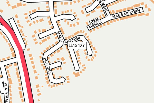
LL15 1XY lies on Bro Deg in Ruthin. LL15 1XY is located in the Ruthin electoral ward, within the unitary authority of Denbighshire and the Welsh Parliamentary constituency of Clwyd West. The Local Health Board is Betsi Cadwaladr University and the police force is North Wales. This postcode has been in use since July 1986.


GetTheData
Source: OS OpenMap – Local (Ordnance Survey)
Source: OS VectorMap District (Ordnance Survey)
Licence: Open Government Licence (requires attribution)
| Easting | 313155 |
| Northing | 357507 |
| Latitude | 53.107673 |
| Longitude | -3.298737 |
GetTheData
Source: Open Postcode Geo
Licence: Open Government Licence
| Street | Bro Deg |
| Town/City | Ruthin |
| Country | Wales |
| Postcode District | LL15 |
➜ See where LL15 is on a map ➜ Where is Ruthin? | |
GetTheData
Source: Land Registry Price Paid Data
Licence: Open Government Licence
Elevation or altitude of LL15 1XY as distance above sea level:
| Metres | Feet | |
|---|---|---|
| Elevation | 90m | 295ft |
Elevation is measured from the approximate centre of the postcode, to the nearest point on an OS contour line from OS Terrain 50, which has contour spacing of ten vertical metres.
➜ How high above sea level am I? Find the elevation of your current position using your device's GPS.
GetTheData
Source: Open Postcode Elevation
Licence: Open Government Licence
| Ward | Ruthin |
| Constituency | Clwyd West |
GetTheData
Source: ONS Postcode Database
Licence: Open Government Licence
2024 2 AUG £225,000 |
120, BRO DEG, RUTHIN, LL15 1XY 2023 9 JUN £220,000 |
118, BRO DEG, RUTHIN, LL15 1XY 2018 5 OCT £176,000 |
2018 24 AUG £177,000 |
83, BRO DEG, RUTHIN, LL15 1XY 2017 25 AUG £188,000 |
2017 17 FEB £190,000 |
100, BRO DEG, RUTHIN, LL15 1XY 2016 4 MAR £184,000 |
2014 7 FEB £177,000 |
2013 2 AUG £155,000 |
2010 1 APR £153,000 |
GetTheData
Source: HM Land Registry Price Paid Data
Licence: Contains HM Land Registry data © Crown copyright and database right 2025. This data is licensed under the Open Government Licence v3.0.
| Maes Cantaba | Ruthin | 159m |
| Castle Park (Llanfair Road) | Ruthin | 206m |
| Castle Park (Wrexham Road) | Ruthin | 215m |
| Pen Y Maes (Llanfair Road) | Ruthin | 312m |
| Castle Park Loop (Pen-y-maes) | Ruthin | 328m |
GetTheData
Source: NaPTAN
Licence: Open Government Licence
| Percentage of properties with Next Generation Access | 100.0% |
| Percentage of properties with Superfast Broadband | 100.0% |
| Percentage of properties with Ultrafast Broadband | 0.0% |
| Percentage of properties with Full Fibre Broadband | 0.0% |
Superfast Broadband is between 30Mbps and 300Mbps
Ultrafast Broadband is > 300Mbps
| Median download speed | 33.1Mbps |
| Average download speed | 31.1Mbps |
| Maximum download speed | 80.00Mbps |
| Median upload speed | 6.7Mbps |
| Average upload speed | 6.0Mbps |
| Maximum upload speed | 20.00Mbps |
| Percentage of properties unable to receive 2Mbps | 0.0% |
| Percentage of properties unable to receive 5Mbps | 0.0% |
| Percentage of properties unable to receive 10Mbps | 0.0% |
| Percentage of properties unable to receive 30Mbps | 0.0% |
GetTheData
Source: Ofcom
Licence: Ofcom Terms of Use (requires attribution)
Estimated total energy consumption in LL15 1XY by fuel type, 2015.
| Consumption (kWh) | 645,613 |
|---|---|
| Meter count | 57 |
| Mean (kWh/meter) | 11,327 |
| Median (kWh/meter) | 10,518 |
| Consumption (kWh) | 208,191 |
|---|---|
| Meter count | 55 |
| Mean (kWh/meter) | 3,785 |
| Median (kWh/meter) | 3,448 |
GetTheData
Source: Postcode level gas estimates: 2015 (experimental)
Source: Postcode level electricity estimates: 2015 (experimental)
Licence: Open Government Licence
GetTheData
Source: ONS Postcode Database
Licence: Open Government Licence


➜ Get more ratings from the Food Standards Agency
GetTheData
Source: Food Standards Agency
Licence: FSA terms & conditions
| Last Collection | |||
|---|---|---|---|
| Location | Mon-Fri | Sat | Distance |
| Castle Park | 17:30 | 10:45 | 287m |
| Bryn Rhydd | 17:30 | 10:45 | 408m |
| Erw Goch | 17:30 | 10:45 | 435m |
GetTheData
Source: Dracos
Licence: Creative Commons Attribution-ShareAlike
The below table lists the International Territorial Level (ITL) codes (formerly Nomenclature of Territorial Units for Statistics (NUTS) codes) and Local Administrative Units (LAU) codes for LL15 1XY:
| ITL 1 Code | Name |
|---|---|
| TLL | Wales |
| ITL 2 Code | Name |
| TLL1 | West Wales and The Valleys |
| ITL 3 Code | Name |
| TLL13 | Conwy and Denbighshire |
| LAU 1 Code | Name |
| W06000004 | Denbighshire |
GetTheData
Source: ONS Postcode Directory
Licence: Open Government Licence
The below table lists the Census Output Area (OA), Lower Layer Super Output Area (LSOA), and Middle Layer Super Output Area (MSOA) for LL15 1XY:
| Code | Name | |
|---|---|---|
| OA | W00001309 | |
| LSOA | W01000244 | Denbighshire 014C |
| MSOA | W02000055 | Denbighshire 014 |
GetTheData
Source: ONS Postcode Directory
Licence: Open Government Licence
| LL15 1YQ | Bro Deg | 96m |
| LL15 1RH | Trem Menlli | 151m |
| LL15 1YP | Maes Cantaba | 161m |
| LL15 1DA | Llanfair Road | 185m |
| LL15 1RG | Llwyn Menlli | 224m |
| LL15 1RF | Maes Menlli | 229m |
| LL15 1RP | Bryn Rhydd | 240m |
| LL15 1RW | Bryn Rhydd | 248m |
| LL15 1RE | Lon Menlli | 257m |
| LL15 1YH | Maes Meugan | 270m |
GetTheData
Source: Open Postcode Geo; Land Registry Price Paid Data
Licence: Open Government Licence