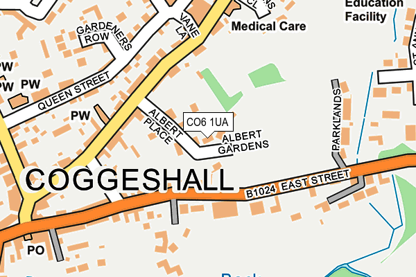
CO6 1UA lies on Albert Gardens in Coggeshall, Colchester. CO6 1UA is located in the Coggeshall electoral ward, within the local authority district of Braintree and the English Parliamentary constituency of Witham. The Sub Integrated Care Board (ICB) Location is NHS Mid and South Essex ICB - 06Q and the police force is Essex. This postcode has been in use since January 1980.


GetTheData
Source: OS OpenMap – Local (Ordnance Survey)
Source: OS VectorMap District (Ordnance Survey)
Licence: Open Government Licence (requires attribution)
| Easting | 585279 |
| Northing | 222691 |
| Latitude | 51.872012 |
| Longitude | 0.689953 |
GetTheData
Source: Open Postcode Geo
Licence: Open Government Licence
| Street | Albert Gardens |
| Locality | Coggeshall |
| Town/City | Colchester |
| Country | England |
| Postcode District | CO6 |
➜ See where CO6 is on a map ➜ Where is Coggeshall? | |
GetTheData
Source: Land Registry Price Paid Data
Licence: Open Government Licence
Elevation or altitude of CO6 1UA as distance above sea level:
| Metres | Feet | |
|---|---|---|
| Elevation | 30m | 98ft |
Elevation is measured from the approximate centre of the postcode, to the nearest point on an OS contour line from OS Terrain 50, which has contour spacing of ten vertical metres.
➜ How high above sea level am I? Find the elevation of your current position using your device's GPS.
GetTheData
Source: Open Postcode Elevation
Licence: Open Government Licence
| Ward | Coggeshall |
| Constituency | Witham |
GetTheData
Source: ONS Postcode Database
Licence: Open Government Licence
2020 29 JUN £400,000 |
3, ALBERT GARDENS, COGGESHALL, COLCHESTER, CO6 1UA 2019 12 DEC £425,000 |
2012 6 JAN £395,000 |
1, ALBERT GARDENS, COGGESHALL, COLCHESTER, CO6 1UA 2009 3 SEP £315,000 |
5, ALBERT GARDENS, COGGESHALL, COLCHESTER, CO6 1UA 2006 14 JUN £312,000 |
2002 2 AUG £167,500 |
2000 12 APR £189,995 |
GetTheData
Source: HM Land Registry Price Paid Data
Licence: Contains HM Land Registry data © Crown copyright and database right 2025. This data is licensed under the Open Government Licence v3.0.
| Vane Lane (Church Street) | Coggeshall | 130m |
| Vane Lane (Church Street) | Coggeshall | 133m |
| Church Street Co-op (Church Green) | Coggeshall | 260m |
| Church Street Co-op (Church Green) | Coggeshall | 263m |
| Market Hill (Church Street) | Coggeshall | 274m |
| Kelvedon Station | 3.6km |
GetTheData
Source: NaPTAN
Licence: Open Government Licence
| Percentage of properties with Next Generation Access | 0.0% |
| Percentage of properties with Superfast Broadband | 0.0% |
| Percentage of properties with Ultrafast Broadband | 0.0% |
| Percentage of properties with Full Fibre Broadband | 0.0% |
Superfast Broadband is between 30Mbps and 300Mbps
Ultrafast Broadband is > 300Mbps
| Percentage of properties unable to receive 2Mbps | 0.0% |
| Percentage of properties unable to receive 5Mbps | 0.0% |
| Percentage of properties unable to receive 10Mbps | 0.0% |
| Percentage of properties unable to receive 30Mbps | 100.0% |
GetTheData
Source: Ofcom
Licence: Ofcom Terms of Use (requires attribution)
GetTheData
Source: ONS Postcode Database
Licence: Open Government Licence


➜ Get more ratings from the Food Standards Agency
GetTheData
Source: Food Standards Agency
Licence: FSA terms & conditions
| Last Collection | |||
|---|---|---|---|
| Location | Mon-Fri | Sat | Distance |
| Church Street Coggeshall | 16:00 | 10:30 | 236m |
| New Lane Feering | 17:00 | 10:30 | 3,407m |
| Rye Mill Lane Kelvedon | 17:00 | 10:30 | 3,497m |
GetTheData
Source: Dracos
Licence: Creative Commons Attribution-ShareAlike
The below table lists the International Territorial Level (ITL) codes (formerly Nomenclature of Territorial Units for Statistics (NUTS) codes) and Local Administrative Units (LAU) codes for CO6 1UA:
| ITL 1 Code | Name |
|---|---|
| TLH | East |
| ITL 2 Code | Name |
| TLH3 | Essex |
| ITL 3 Code | Name |
| TLH34 | Essex Haven Gateway |
| LAU 1 Code | Name |
| E07000067 | Braintree |
GetTheData
Source: ONS Postcode Directory
Licence: Open Government Licence
The below table lists the Census Output Area (OA), Lower Layer Super Output Area (LSOA), and Middle Layer Super Output Area (MSOA) for CO6 1UA:
| Code | Name | |
|---|---|---|
| OA | E00108593 | |
| LSOA | E01021377 | Braintree 014A |
| MSOA | E02004459 | Braintree 014 |
GetTheData
Source: ONS Postcode Directory
Licence: Open Government Licence
| CO6 1TZ | Albert Place | 42m |
| CO6 1SJ | East Street | 110m |
| CO6 1TY | Church Street | 114m |
| CO6 1TX | Church Street | 146m |
| CO6 1UR | Vane Lane | 160m |
| CO6 1TN | Lakes Meadow | 163m |
| CO6 1QX | Queen Street | 179m |
| CO6 1UF | Queen Street | 195m |
| CO6 1SW | Parklands | 203m |
| CO6 1UB | Church Street | 208m |
GetTheData
Source: Open Postcode Geo; Land Registry Price Paid Data
Licence: Open Government Licence