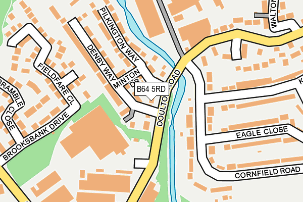
B64 5RD is located in the Rowley electoral ward, within the metropolitan district of Sandwell and the English Parliamentary constituency of Halesowen and Rowley Regis. The Sub Integrated Care Board (ICB) Location is NHS Black Country ICB - D2P2L and the police force is West Midlands. This postcode has been in use since June 2017.


GetTheData
Source: OS OpenMap – Local (Ordnance Survey)
Source: OS VectorMap District (Ordnance Survey)
Licence: Open Government Licence (requires attribution)
| Easting | 395695 |
| Northing | 287823 |
| Latitude | 52.488320 |
| Longitude | -2.064822 |
GetTheData
Source: Open Postcode Geo
Licence: Open Government Licence
| Country | England |
| Postcode District | B64 |
➜ See where B64 is on a map ➜ Where is Rowley Regis? | |
GetTheData
Source: Land Registry Price Paid Data
Licence: Open Government Licence
| Ward | Rowley |
| Constituency | Halesowen And Rowley Regis |
GetTheData
Source: ONS Postcode Database
Licence: Open Government Licence
2024 20 JUN £350,000 |
2023 24 NOV £370,000 |
2023 31 OCT £340,000 |
2019 8 MAR £294,995 |
10, DENBY WAY, CRADLEY HEATH, B64 5RD 2018 14 DEC £249,995 |
12, DENBY WAY, CRADLEY HEATH, B64 5RD 2018 14 DEC £284,995 |
64, DENBY WAY, CRADLEY HEATH, B64 5RD 2018 30 NOV £267,995 |
8, DENBY WAY, CRADLEY HEATH, B64 5RD 2018 30 NOV £309,995 |
62, DENBY WAY, CRADLEY HEATH, B64 5RD 2018 30 NOV £267,995 |
58, DENBY WAY, CRADLEY HEATH, B64 5RD 2018 26 OCT £299,995 |
GetTheData
Source: HM Land Registry Price Paid Data
Licence: Contains HM Land Registry data © Crown copyright and database right 2025. This data is licensed under the Open Government Licence v3.0.
| Knowle Rd (Cornfield Rd) | Brickhouse Farm | 235m |
| Knowle Rd (Cornfield Rd) | Brickhouse Farm | 252m |
| Darby End Estate (Windmill End) | Darby End | 289m |
| Darby End Estate (Windmill End) | Darby End | 290m |
| Brooksbank Drive (Gawne Lane) | Brickhouse Farm | 342m |
| Old Hill Station | 2km |
| Rowley Regis Station | 2.6km |
| Cradley Heath Station | 2.7km |
GetTheData
Source: NaPTAN
Licence: Open Government Licence
| Percentage of properties with Next Generation Access | 100.0% |
| Percentage of properties with Superfast Broadband | 100.0% |
| Percentage of properties with Ultrafast Broadband | 100.0% |
| Percentage of properties with Full Fibre Broadband | 100.0% |
Superfast Broadband is between 30Mbps and 300Mbps
Ultrafast Broadband is > 300Mbps
| Median download speed | 100.0Mbps |
| Average download speed | 146.9Mbps |
| Maximum download speed | 350.00Mbps |
Ofcom does not currently provide upload speed data for B64 5RD. This is because there are less than four broadband connections in this postcode.
| Percentage of properties unable to receive 2Mbps | 0.0% |
| Percentage of properties unable to receive 5Mbps | 0.0% |
| Percentage of properties unable to receive 10Mbps | 0.0% |
| Percentage of properties unable to receive 30Mbps | 0.0% |
GetTheData
Source: Ofcom
Licence: Ofcom Terms of Use (requires attribution)
GetTheData
Source: ONS Postcode Database
Licence: Open Government Licence


➜ Get more ratings from the Food Standards Agency
GetTheData
Source: Food Standards Agency
Licence: FSA terms & conditions
| Last Collection | |||
|---|---|---|---|
| Location | Mon-Fri | Sat | Distance |
| Counterfield Drive / Blackberr | 17:30 | 12:00 | 656m |
| Powke Lane / Coxs Lane | 17:30 | 12:00 | 709m |
| Molyneux Road | 17:30 | 11:00 | 847m |
GetTheData
Source: Dracos
Licence: Creative Commons Attribution-ShareAlike
The below table lists the International Territorial Level (ITL) codes (formerly Nomenclature of Territorial Units for Statistics (NUTS) codes) and Local Administrative Units (LAU) codes for B64 5RD:
| ITL 1 Code | Name |
|---|---|
| TLG | West Midlands (England) |
| ITL 2 Code | Name |
| TLG3 | West Midlands |
| ITL 3 Code | Name |
| TLG37 | Sandwell |
| LAU 1 Code | Name |
| E08000028 | Sandwell |
GetTheData
Source: ONS Postcode Directory
Licence: Open Government Licence
The below table lists the Census Output Area (OA), Lower Layer Super Output Area (LSOA), and Middle Layer Super Output Area (MSOA) for B64 5RD:
| Code | Name | |
|---|---|---|
| OA | E00050784 | |
| LSOA | E01010039 | Sandwell 025A |
| MSOA | E02002067 | Sandwell 025 |
GetTheData
Source: ONS Postcode Directory
Licence: Open Government Licence
| B64 5QH | Fieldfare Close | 117m |
| B64 5QG | Brooksbank Drive | 205m |
| B64 5QQ | Bramble Close | 207m |
| B65 8JQ | Doulton Trading Estate | 211m |
| B65 8PH | Bridgefield Walk | 222m |
| B65 8HZ | Cornfield Place | 247m |
| B65 8PE | Old Bridge Walk | 255m |
| B65 8PF | Old Bridge Walk | 289m |
| B65 8JB | Allsops Close | 290m |
| B65 8HJ | Cornfield Road | 297m |
GetTheData
Source: Open Postcode Geo; Land Registry Price Paid Data
Licence: Open Government Licence