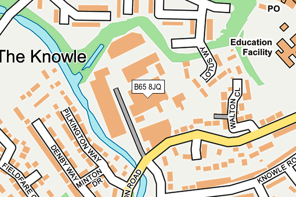
B65 8JQ lies on Doulton Trading Estate in Rowley Regis. B65 8JQ is located in the Rowley electoral ward, within the metropolitan district of Sandwell and the English Parliamentary constituency of Halesowen and Rowley Regis. The Sub Integrated Care Board (ICB) Location is NHS Black Country ICB - D2P2L and the police force is West Midlands. This postcode has been in use since March 1982.


GetTheData
Source: OS OpenMap – Local (Ordnance Survey)
Source: OS VectorMap District (Ordnance Survey)
Licence: Open Government Licence (requires attribution)
| Easting | 395898 |
| Northing | 287880 |
| Latitude | 52.488834 |
| Longitude | -2.061834 |
GetTheData
Source: Open Postcode Geo
Licence: Open Government Licence
| Street | Doulton Trading Estate |
| Town/City | Rowley Regis |
| Country | England |
| Postcode District | B65 |
➜ See where B65 is on a map ➜ Where is Rowley Regis? | |
GetTheData
Source: Land Registry Price Paid Data
Licence: Open Government Licence
Elevation or altitude of B65 8JQ as distance above sea level:
| Metres | Feet | |
|---|---|---|
| Elevation | 150m | 492ft |
Elevation is measured from the approximate centre of the postcode, to the nearest point on an OS contour line from OS Terrain 50, which has contour spacing of ten vertical metres.
➜ How high above sea level am I? Find the elevation of your current position using your device's GPS.
GetTheData
Source: Open Postcode Elevation
Licence: Open Government Licence
| Ward | Rowley |
| Constituency | Halesowen And Rowley Regis |
GetTheData
Source: ONS Postcode Database
Licence: Open Government Licence
| Knowle Rd (Cornfield Rd) | Brickhouse Farm | 140m |
| Knowle Rd (Cornfield Rd) | Brickhouse Farm | 180m |
| Knowle Rd (Harvest Rd) | Brickhouse Farm | 298m |
| Knowle Rd (Harvest Rd) | Brickhouse Farm | 304m |
| Doulton Rd (Knowle Rd) | Brickhouse Farm | 373m |
| Old Hill Station | 2km |
| Rowley Regis Station | 2.5km |
| Cradley Heath Station | 2.9km |
GetTheData
Source: NaPTAN
Licence: Open Government Licence
| Median download speed | 3.7Mbps |
| Average download speed | 18.8Mbps |
| Maximum download speed | 80.00Mbps |
| Median upload speed | 0.7Mbps |
| Average upload speed | 4.6Mbps |
| Maximum upload speed | 20.00Mbps |
GetTheData
Source: Ofcom
Licence: Ofcom Terms of Use (requires attribution)
GetTheData
Source: ONS Postcode Database
Licence: Open Government Licence


➜ Get more ratings from the Food Standards Agency
GetTheData
Source: Food Standards Agency
Licence: FSA terms & conditions
| Last Collection | |||
|---|---|---|---|
| Location | Mon-Fri | Sat | Distance |
| Counterfield Drive / Blackberr | 17:30 | 12:00 | 616m |
| Powke Lane / Coxs Lane | 17:30 | 12:00 | 759m |
| Tippity Green | 17:30 | 12:00 | 815m |
GetTheData
Source: Dracos
Licence: Creative Commons Attribution-ShareAlike
The below table lists the International Territorial Level (ITL) codes (formerly Nomenclature of Territorial Units for Statistics (NUTS) codes) and Local Administrative Units (LAU) codes for B65 8JQ:
| ITL 1 Code | Name |
|---|---|
| TLG | West Midlands (England) |
| ITL 2 Code | Name |
| TLG3 | West Midlands |
| ITL 3 Code | Name |
| TLG37 | Sandwell |
| LAU 1 Code | Name |
| E08000028 | Sandwell |
GetTheData
Source: ONS Postcode Directory
Licence: Open Government Licence
The below table lists the Census Output Area (OA), Lower Layer Super Output Area (LSOA), and Middle Layer Super Output Area (MSOA) for B65 8JQ:
| Code | Name | |
|---|---|---|
| OA | E00050808 | |
| LSOA | E01010044 | Sandwell 025C |
| MSOA | E02002067 | Sandwell 025 |
GetTheData
Source: ONS Postcode Directory
Licence: Open Government Licence
| B65 8HZ | Cornfield Place | 125m |
| B65 8PN | Lotus Way | 137m |
| B65 8JB | Allsops Close | 140m |
| B65 8JN | Walton Close | 152m |
| B65 8PA | Finch Close | 171m |
| B65 8NZ | Lightfields Walk | 190m |
| B65 8JA | Kiln Croft | 205m |
| B65 8PB | Ambell Close | 215m |
| B65 8PH | Bridgefield Walk | 217m |
| B65 8HH | Knowle Road | 218m |
GetTheData
Source: Open Postcode Geo; Land Registry Price Paid Data
Licence: Open Government Licence