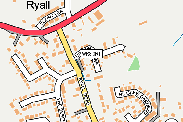
WR8 0RT is located in the Upton & Ripple electoral ward, within the local authority district of Malvern Hills and the English Parliamentary constituency of West Worcestershire. The Sub Integrated Care Board (ICB) Location is NHS Herefordshire and Worcestershire ICB - 18C and the police force is West Mercia. This postcode has been in use since February 2017.


GetTheData
Source: OS OpenMap – Local (Ordnance Survey)
Source: OS VectorMap District (Ordnance Survey)
Licence: Open Government Licence (requires attribution)
| Easting | 386237 |
| Northing | 240963 |
| Latitude | 52.066875 |
| Longitude | -2.202179 |
GetTheData
Source: Open Postcode Geo
Licence: Open Government Licence
| Country | England |
| Postcode District | WR8 |
➜ See where WR8 is on a map ➜ Where is Ryall? | |
GetTheData
Source: Land Registry Price Paid Data
Licence: Open Government Licence
| Ward | Upton & Ripple |
| Constituency | West Worcestershire |
GetTheData
Source: ONS Postcode Database
Licence: Open Government Licence
2021 17 SEP £305,000 |
2021 23 JUN £380,000 |
2021 16 FEB £465,000 |
2020 17 NOV £196,000 |
2019 26 JUN £360,000 |
2018 20 DEC £390,000 |
2018 26 OCT £269,995 |
2018 5 SEP £437,495 |
2018 22 JUN £181,997 |
16, FURROW CLOSE, HOLLY GREEN, WORCESTER, WR8 0RT 2018 6 APR £389,995 |
GetTheData
Source: HM Land Registry Price Paid Data
Licence: Contains HM Land Registry data © Crown copyright and database right 2025. This data is licensed under the Open Government Licence v3.0.
| Ryall Road (A4104) | Holly Green | 170m |
| Ryall Village (Upton Road) | Ryall | 368m |
| Ryall Village (Upton Road) | Ryall | 375m |
| Grove Motors (A38) | Ryall | 489m |
| Bluebell Farm (A38) | Holly Green | 547m |
GetTheData
Source: NaPTAN
Licence: Open Government Licence
| Percentage of properties with Next Generation Access | 100.0% |
| Percentage of properties with Superfast Broadband | 100.0% |
| Percentage of properties with Ultrafast Broadband | 0.0% |
| Percentage of properties with Full Fibre Broadband | 0.0% |
Superfast Broadband is between 30Mbps and 300Mbps
Ultrafast Broadband is > 300Mbps
| Median download speed | 67.0Mbps |
| Average download speed | 54.5Mbps |
| Maximum download speed | 80.00Mbps |
| Median upload speed | 18.4Mbps |
| Average upload speed | 13.3Mbps |
| Maximum upload speed | 20.00Mbps |
| Percentage of properties unable to receive 2Mbps | 0.0% |
| Percentage of properties unable to receive 5Mbps | 0.0% |
| Percentage of properties unable to receive 10Mbps | 0.0% |
| Percentage of properties unable to receive 30Mbps | 0.0% |
GetTheData
Source: Ofcom
Licence: Ofcom Terms of Use (requires attribution)
GetTheData
Source: ONS Postcode Database
Licence: Open Government Licence


➜ Get more ratings from the Food Standards Agency
GetTheData
Source: Food Standards Agency
Licence: FSA terms & conditions
| Last Collection | |||
|---|---|---|---|
| Location | Mon-Fri | Sat | Distance |
| Holly Green | 16:45 | 09:45 | 189m |
| Ryall | 16:30 | 09:45 | 280m |
| Willow Close | 16:30 | 09:00 | 619m |
GetTheData
Source: Dracos
Licence: Creative Commons Attribution-ShareAlike
The below table lists the International Territorial Level (ITL) codes (formerly Nomenclature of Territorial Units for Statistics (NUTS) codes) and Local Administrative Units (LAU) codes for WR8 0RT:
| ITL 1 Code | Name |
|---|---|
| TLG | West Midlands (England) |
| ITL 2 Code | Name |
| TLG1 | Herefordshire, Worcestershire and Warwickshire |
| ITL 3 Code | Name |
| TLG12 | Worcestershire CC |
| LAU 1 Code | Name |
| E07000235 | Malvern Hills |
GetTheData
Source: ONS Postcode Directory
Licence: Open Government Licence
The below table lists the Census Output Area (OA), Lower Layer Super Output Area (LSOA), and Middle Layer Super Output Area (MSOA) for WR8 0RT:
| Code | Name | |
|---|---|---|
| OA | E00164302 | |
| LSOA | E01032211 | Malvern Hills 008C |
| MSOA | E02006717 | Malvern Hills 008 |
GetTheData
Source: ONS Postcode Directory
Licence: Open Government Licence
| WR8 0PG | Ryall Road | 157m |
| WR8 0QJ | Hill View Gardens | 197m |
| WR8 0QF | The Beeches | 201m |
| WR8 0PE | Court Lea | 221m |
| WR8 0QQ | The Beeches | 251m |
| WR8 0PD | 259m | |
| WR8 0PQ | The Woodlands | 342m |
| WR8 0QH | Orchard Close | 378m |
| WR8 0PH | Hollygrove | 380m |
| WR8 0PJ | Ryall Meadow | 456m |
GetTheData
Source: Open Postcode Geo; Land Registry Price Paid Data
Licence: Open Government Licence