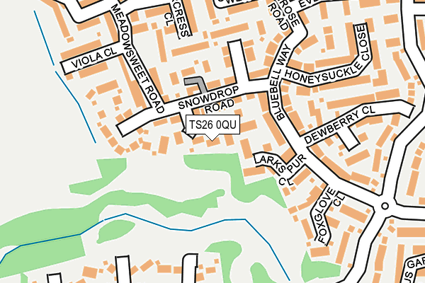
TS26 0QU lies on Eyebright Close in Hartlepool. TS26 0QU is located in the Hart electoral ward, within the unitary authority of Hartlepool and the English Parliamentary constituency of Hartlepool. The Sub Integrated Care Board (ICB) Location is NHS North East and North Cumbria ICB - 16C and the police force is Cleveland. This postcode has been in use since January 2007.


GetTheData
Source: OS OpenMap – Local (Ordnance Survey)
Source: OS VectorMap District (Ordnance Survey)
Licence: Open Government Licence (requires attribution)
| Easting | 448763 |
| Northing | 534576 |
| Latitude | 54.703853 |
| Longitude | -1.244802 |
GetTheData
Source: Open Postcode Geo
Licence: Open Government Licence
| Street | Eyebright Close |
| Town/City | Hartlepool |
| Country | England |
| Postcode District | TS26 |
➜ See where TS26 is on a map ➜ Where is Hartlepool? | |
GetTheData
Source: Land Registry Price Paid Data
Licence: Open Government Licence
Elevation or altitude of TS26 0QU as distance above sea level:
| Metres | Feet | |
|---|---|---|
| Elevation | 40m | 131ft |
Elevation is measured from the approximate centre of the postcode, to the nearest point on an OS contour line from OS Terrain 50, which has contour spacing of ten vertical metres.
➜ How high above sea level am I? Find the elevation of your current position using your device's GPS.
GetTheData
Source: Open Postcode Elevation
Licence: Open Government Licence
| Ward | Hart |
| Constituency | Hartlepool |
GetTheData
Source: ONS Postcode Database
Licence: Open Government Licence
2021 18 MAY £425,000 |
2020 30 OCT £352,000 |
2010 22 OCT £402,500 |
5, EYEBRIGHT CLOSE, HARTLEPOOL, TS26 0QU 2009 2 OCT £394,000 |
2006 19 DEC £369,495 |
2006 6 DEC £331,995 |
2006 1 DEC £392,000 |
3, EYEBRIGHT CLOSE, HARTLEPOOL, TS26 0QU 2006 30 NOV £399,995 |
GetTheData
Source: HM Land Registry Price Paid Data
Licence: Contains HM Land Registry data © Crown copyright and database right 2025. This data is licensed under the Open Government Licence v3.0.
| Bluebell Way (Merlin Way) | Throston Grange | 251m |
| Bluebell Way (Merlin Way) | Throston Grange | 262m |
| Goshawk Road (Merlin Way) | Throston Grange | 393m |
| Guillemot Road (Merlin Way) | Throston Grange | 461m |
| Easington Road (Hart Road/A179) | West View | 505m |
| Hartlepool Station | 3.1km |
GetTheData
Source: NaPTAN
Licence: Open Government Licence
| Percentage of properties with Next Generation Access | 100.0% |
| Percentage of properties with Superfast Broadband | 100.0% |
| Percentage of properties with Ultrafast Broadband | 0.0% |
| Percentage of properties with Full Fibre Broadband | 0.0% |
Superfast Broadband is between 30Mbps and 300Mbps
Ultrafast Broadband is > 300Mbps
| Percentage of properties unable to receive 2Mbps | 0.0% |
| Percentage of properties unable to receive 5Mbps | 0.0% |
| Percentage of properties unable to receive 10Mbps | 0.0% |
| Percentage of properties unable to receive 30Mbps | 0.0% |
GetTheData
Source: Ofcom
Licence: Ofcom Terms of Use (requires attribution)
GetTheData
Source: ONS Postcode Database
Licence: Open Government Licence


➜ Get more ratings from the Food Standards Agency
GetTheData
Source: Food Standards Agency
Licence: FSA terms & conditions
| Last Collection | |||
|---|---|---|---|
| Location | Mon-Fri | Sat | Distance |
| Elmwood Road | 17:30 | 12:30 | 1,220m |
| Ocean Road, Hart Station | 17:30 | 12:00 | 1,643m |
| Park Road | 18:00 | 12:30 | 1,787m |
GetTheData
Source: Dracos
Licence: Creative Commons Attribution-ShareAlike
The below table lists the International Territorial Level (ITL) codes (formerly Nomenclature of Territorial Units for Statistics (NUTS) codes) and Local Administrative Units (LAU) codes for TS26 0QU:
| ITL 1 Code | Name |
|---|---|
| TLC | North East (England) |
| ITL 2 Code | Name |
| TLC1 | Tees Valley and Durham |
| ITL 3 Code | Name |
| TLC11 | Hartlepool and Stockton-on-Tees |
| LAU 1 Code | Name |
| E06000001 | Hartlepool |
GetTheData
Source: ONS Postcode Directory
Licence: Open Government Licence
The below table lists the Census Output Area (OA), Lower Layer Super Output Area (LSOA), and Middle Layer Super Output Area (MSOA) for TS26 0QU:
| Code | Name | |
|---|---|---|
| OA | E00174101 | |
| LSOA | E01033467 | Hartlepool 001G |
| MSOA | E02002483 | Hartlepool 001 |
GetTheData
Source: ONS Postcode Directory
Licence: Open Government Licence
| TS26 0WN | Snowdrop Road | 62m |
| TS26 0WG | Snowdrop Road | 80m |
| TS26 0WD | Larkspur Close | 94m |
| TS26 0WF | Bluebell Way | 121m |
| TS26 0WH | Brooklime Close | 147m |
| TS26 0QZ | Meadowsweet Road | 164m |
| TS26 0QR | Meadowsweet Road | 176m |
| TS26 0WB | Foxglove Close | 192m |
| TS26 0QY | Watercress Close | 201m |
| TS26 0RW | Honeysuckle Close | 215m |
GetTheData
Source: Open Postcode Geo; Land Registry Price Paid Data
Licence: Open Government Licence