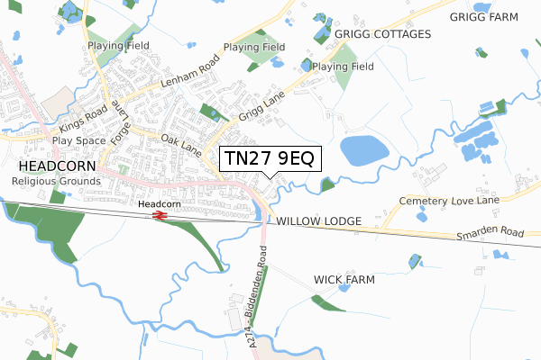
TN27 9EQ is located in the Headcorn electoral ward, within the local authority district of Maidstone and the English Parliamentary constituency of Faversham and Mid Kent. The Sub Integrated Care Board (ICB) Location is NHS Kent and Medway ICB - 91Q and the police force is Kent. This postcode has been in use since May 2018.


GetTheData
Source: OS Open Zoomstack (Ordnance Survey)
Licence: Open Government Licence (requires attribution)
Attribution: Contains OS data © Crown copyright and database right 2025
Source: Open Postcode Geo
Licence: Open Government Licence (requires attribution)
Attribution: Contains OS data © Crown copyright and database right 2025; Contains Royal Mail data © Royal Mail copyright and database right 2025; Source: Office for National Statistics licensed under the Open Government Licence v.3.0
| Easting | 584293 |
| Northing | 144156 |
| Latitude | 51.166954 |
| Longitude | 0.634636 |
GetTheData
Source: Open Postcode Geo
Licence: Open Government Licence
| Country | England |
| Postcode District | TN27 |
➜ See where TN27 is on a map ➜ Where is Headcorn? | |
GetTheData
Source: Land Registry Price Paid Data
Licence: Open Government Licence
| Ward | Headcorn |
| Constituency | Faversham And Mid Kent |
GetTheData
Source: ONS Postcode Database
Licence: Open Government Licence
18, SMITH WAY, HEADCORN, ASHFORD, TN27 9EQ 2021 11 JUN £595,000 |
14, SMITH WAY, HEADCORN, ASHFORD, TN27 9EQ 2021 26 MAY £620,000 |
2021 31 MAR £679,000 |
11, SMITH WAY, HEADCORN, ASHFORD, TN27 9EQ 2021 26 MAR £550,000 |
15, SMITH WAY, HEADCORN, ASHFORD, TN27 9EQ 2021 24 MAR £600,000 |
19, SMITH WAY, HEADCORN, ASHFORD, TN27 9EQ 2021 12 MAR £650,000 |
12, SMITH WAY, HEADCORN, ASHFORD, TN27 9EQ 2020 13 NOV £450,000 |
13, SMITH WAY, HEADCORN, ASHFORD, TN27 9EQ 2020 17 JUL £490,000 |
16, SMITH WAY, HEADCORN, ASHFORD, TN27 9EQ 2020 15 JUL £600,000 |
10, SMITH WAY, HEADCORN, ASHFORD, TN27 9EQ 2020 30 JUN £425,000 |
GetTheData
Source: HM Land Registry Price Paid Data
Licence: Contains HM Land Registry data © Crown copyright and database right 2025. This data is licensed under the Open Government Licence v3.0.
| Gibbs Hill (Wheeler Street) | Headcorn | 251m |
| Gibbs Hill (Wheeler Street) | Headcorn | 294m |
| Railway Station (Station Road) | Headcorn | 485m |
| Railway Station Forecourt (Station Approach) | Headcorn | 516m |
| Railway Station (Station Road) | Headcorn | 528m |
| Headcorn Station | 0.5km |
GetTheData
Source: NaPTAN
Licence: Open Government Licence
| Percentage of properties with Next Generation Access | 100.0% |
| Percentage of properties with Superfast Broadband | 100.0% |
| Percentage of properties with Ultrafast Broadband | 0.0% |
| Percentage of properties with Full Fibre Broadband | 0.0% |
Superfast Broadband is between 30Mbps and 300Mbps
Ultrafast Broadband is > 300Mbps
| Percentage of properties unable to receive 2Mbps | 0.0% |
| Percentage of properties unable to receive 5Mbps | 0.0% |
| Percentage of properties unable to receive 10Mbps | 0.0% |
| Percentage of properties unable to receive 30Mbps | 0.0% |
GetTheData
Source: Ofcom
Licence: Ofcom Terms of Use (requires attribution)
GetTheData
Source: ONS Postcode Database
Licence: Open Government Licence


➜ Get more ratings from the Food Standards Agency
GetTheData
Source: Food Standards Agency
Licence: FSA terms & conditions
| Last Collection | |||
|---|---|---|---|
| Location | Mon-Fri | Sat | Distance |
| Smarden Road | 16:00 | 09:00 | 543m |
| Swifts Green | 16:45 | 09:00 | 2,857m |
| Bell Inn | 16:45 | 09:30 | 2,942m |
GetTheData
Source: Dracos
Licence: Creative Commons Attribution-ShareAlike
| Risk of TN27 9EQ flooding from rivers and sea | Medium |
| ➜ TN27 9EQ flood map | |
GetTheData
Source: Open Flood Risk by Postcode
Licence: Open Government Licence
The below table lists the International Territorial Level (ITL) codes (formerly Nomenclature of Territorial Units for Statistics (NUTS) codes) and Local Administrative Units (LAU) codes for TN27 9EQ:
| ITL 1 Code | Name |
|---|---|
| TLJ | South East (England) |
| ITL 2 Code | Name |
| TLJ4 | Kent |
| ITL 3 Code | Name |
| TLJ45 | Mid Kent |
| LAU 1 Code | Name |
| E07000110 | Maidstone |
GetTheData
Source: ONS Postcode Directory
Licence: Open Government Licence
The below table lists the Census Output Area (OA), Lower Layer Super Output Area (LSOA), and Middle Layer Super Output Area (MSOA) for TN27 9EQ:
| Code | Name | |
|---|---|---|
| OA | E00123691 | |
| LSOA | E01024365 | Maidstone 017B |
| MSOA | E02005084 | Maidstone 017 |
GetTheData
Source: ONS Postcode Directory
Licence: Open Government Licence
| TN27 9TA | The Terrace | 81m |
| TN27 9SQ | Sherway Close | 82m |
| TN27 9AD | Locks Yard | 88m |
| TN27 9UD | Gibbs Hill | 155m |
| TN27 9UG | Downs Close | 162m |
| TN27 9ST | Wheeler Street | 164m |
| TN27 9SU | Tollgate Place | 164m |
| TN27 9SN | Palmers Yard | 197m |
| TN27 9UF | Sharps Field | 220m |
| TN27 9SS | Orchard Glade | 247m |
GetTheData
Source: Open Postcode Geo; Land Registry Price Paid Data
Licence: Open Government Licence