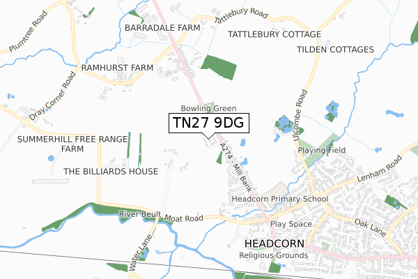
TN27 9DG is located in the Headcorn electoral ward, within the local authority district of Maidstone and the English Parliamentary constituency of Faversham and Mid Kent. The Sub Integrated Care Board (ICB) Location is NHS Kent and Medway ICB - 91Q and the police force is Kent. This postcode has been in use since December 2019.


GetTheData
Source: OS Open Zoomstack (Ordnance Survey)
Licence: Open Government Licence (requires attribution)
Attribution: Contains OS data © Crown copyright and database right 2025
Source: Open Postcode Geo
Licence: Open Government Licence (requires attribution)
Attribution: Contains OS data © Crown copyright and database right 2025; Contains Royal Mail data © Royal Mail copyright and database right 2025; Source: Office for National Statistics licensed under the Open Government Licence v.3.0
| Easting | 582915 |
| Northing | 144843 |
| Latitude | 51.173567 |
| Longitude | 0.615297 |
GetTheData
Source: Open Postcode Geo
Licence: Open Government Licence
| Country | England |
| Postcode District | TN27 |
➜ See where TN27 is on a map ➜ Where is Headcorn? | |
GetTheData
Source: Land Registry Price Paid Data
Licence: Open Government Licence
| Ward | Headcorn |
| Constituency | Faversham And Mid Kent |
GetTheData
Source: ONS Postcode Database
Licence: Open Government Licence
9, WINDMILL CRESCENT, HEADCORN, ASHFORD, TN27 9DG 2022 31 MAY £584,995 |
2022 4 MAR £530,000 |
1, WINDMILL CRESCENT, HEADCORN, ASHFORD, TN27 9DG 2021 30 MAR £449,995 |
2, WINDMILL CRESCENT, HEADCORN, ASHFORD, TN27 9DG 2020 25 SEP £449,995 |
2020 17 SEP £474,995 |
7, WINDMILL CRESCENT, HEADCORN, ASHFORD, TN27 9DG 2020 15 SEP £439,995 |
2020 24 APR £499,995 |
16, WINDMILL CRESCENT, HEADCORN, ASHFORD, TN27 9DG 2019 11 DEC £370,000 |
GetTheData
Source: HM Land Registry Price Paid Data
Licence: Contains HM Land Registry data © Crown copyright and database right 2025. This data is licensed under the Open Government Licence v3.0.
| Bankfields (Mill Bank) | Headcorn | 353m |
| Bankfields (Mill Bank) | Headcorn | 385m |
| Stonestile Road (Maidstone Road) | Headcorn | 523m |
| Stonestile Road (Maidstone Road (A274)) | Headcorn | 567m |
| George And Dragon (High Street) | Headcorn | 780m |
| Headcorn Station | 1.2km |
| Staplehurst Station | 4.5km |
GetTheData
Source: NaPTAN
Licence: Open Government Licence
GetTheData
Source: ONS Postcode Database
Licence: Open Government Licence


➜ Get more ratings from the Food Standards Agency
GetTheData
Source: Food Standards Agency
Licence: FSA terms & conditions
| Last Collection | |||
|---|---|---|---|
| Location | Mon-Fri | Sat | Distance |
| Smarden Road | 16:00 | 09:00 | 2,082m |
| Frittenden Post Office | 16:45 | 09:45 | 3,878m |
| Southernden | 16:15 | 09:15 | 4,011m |
GetTheData
Source: Dracos
Licence: Creative Commons Attribution-ShareAlike
The below table lists the International Territorial Level (ITL) codes (formerly Nomenclature of Territorial Units for Statistics (NUTS) codes) and Local Administrative Units (LAU) codes for TN27 9DG:
| ITL 1 Code | Name |
|---|---|
| TLJ | South East (England) |
| ITL 2 Code | Name |
| TLJ4 | Kent |
| ITL 3 Code | Name |
| TLJ45 | Mid Kent |
| LAU 1 Code | Name |
| E07000110 | Maidstone |
GetTheData
Source: ONS Postcode Directory
Licence: Open Government Licence
The below table lists the Census Output Area (OA), Lower Layer Super Output Area (LSOA), and Middle Layer Super Output Area (MSOA) for TN27 9DG:
| Code | Name | |
|---|---|---|
| OA | E00123686 | |
| LSOA | E01024365 | Maidstone 017B |
| MSOA | E02005084 | Maidstone 017 |
GetTheData
Source: ONS Postcode Directory
Licence: Open Government Licence
| TN27 9RH | Mill Bank | 72m |
| TN27 9RJ | Mill Bank | 86m |
| TN27 9RG | Mill Bank | 88m |
| TN27 9RE | Mill Bank | 141m |
| TN27 9RB | Mill Bank | 215m |
| TN27 9JT | Black Mill Lane | 262m |
| TN27 9RD | Mill Bank | 328m |
| TN27 9QY | Bankfields | 379m |
| TN27 9RL | West View | 390m |
| TN27 9LD | Ulcombe Road | 398m |
GetTheData
Source: Open Postcode Geo; Land Registry Price Paid Data
Licence: Open Government Licence