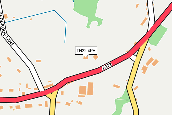
TN22 4PH lies on Pound Green in Buxted, Uckfield. TN22 4PH is located in the Buxted electoral ward, within the local authority district of Wealden and the English Parliamentary constituency of Wealden. The Sub Integrated Care Board (ICB) Location is NHS Sussex ICB - 97R and the police force is Sussex. This postcode has been in use since January 1980.


GetTheData
Source: OS OpenMap – Local (Ordnance Survey)
Source: OS VectorMap District (Ordnance Survey)
Licence: Open Government Licence (requires attribution)
| Easting | 551024 |
| Northing | 123759 |
| Latitude | 50.993418 |
| Longitude | 0.150634 |
GetTheData
Source: Open Postcode Geo
Licence: Open Government Licence
| Street | Pound Green |
| Locality | Buxted |
| Town/City | Uckfield |
| Country | England |
| Postcode District | TN22 |
➜ See where TN22 is on a map ➜ Where is Buxted? | |
GetTheData
Source: Land Registry Price Paid Data
Licence: Open Government Licence
Elevation or altitude of TN22 4PH as distance above sea level:
| Metres | Feet | |
|---|---|---|
| Elevation | 90m | 295ft |
Elevation is measured from the approximate centre of the postcode, to the nearest point on an OS contour line from OS Terrain 50, which has contour spacing of ten vertical metres.
➜ How high above sea level am I? Find the elevation of your current position using your device's GPS.
GetTheData
Source: Open Postcode Elevation
Licence: Open Government Licence
| Ward | Buxted |
| Constituency | Wealden |
GetTheData
Source: ONS Postcode Database
Licence: Open Government Licence
2010 12 APR £545,000 |
THE COTTAGE, BROWN HEATH HOUSE, POUND GREEN, BUXTED, UCKFIELD, TN22 4PH 2005 14 OCT £850,000 |
1996 28 AUG £202,250 |
GetTheData
Source: HM Land Registry Price Paid Data
Licence: Contains HM Land Registry data © Crown copyright and database right 2025. This data is licensed under the Open Government Licence v3.0.
| Tarnhurst (A272) | Pound Green | 375m |
| Tarnhurst (A272) | Pound Green | 390m |
| Littlewood Lane (High Street) | Potter's Green | 761m |
| Littlewood Lane (High Street) | Potter's Green | 776m |
| Buxted Court (Gordon Road) | Buxted | 1,065m |
| Buxted Station | 1.4km |
| Uckfield Station | 4.7km |
GetTheData
Source: NaPTAN
Licence: Open Government Licence
| Percentage of properties with Next Generation Access | 100.0% |
| Percentage of properties with Superfast Broadband | 75.0% |
| Percentage of properties with Ultrafast Broadband | 0.0% |
| Percentage of properties with Full Fibre Broadband | 0.0% |
Superfast Broadband is between 30Mbps and 300Mbps
Ultrafast Broadband is > 300Mbps
| Percentage of properties unable to receive 2Mbps | 0.0% |
| Percentage of properties unable to receive 5Mbps | 0.0% |
| Percentage of properties unable to receive 10Mbps | 0.0% |
| Percentage of properties unable to receive 30Mbps | 25.0% |
GetTheData
Source: Ofcom
Licence: Ofcom Terms of Use (requires attribution)
GetTheData
Source: ONS Postcode Database
Licence: Open Government Licence


➜ Get more ratings from the Food Standards Agency
GetTheData
Source: Food Standards Agency
Licence: FSA terms & conditions
| Last Collection | |||
|---|---|---|---|
| Location | Mon-Fri | Sat | Distance |
| Saxon Court | 17:00 | 09:45 | 391m |
| Buxted Old Post Office | 17:15 | 10:30 | 1,310m |
| Shanty | 16:45 | 09:45 | 1,696m |
GetTheData
Source: Dracos
Licence: Creative Commons Attribution-ShareAlike
The below table lists the International Territorial Level (ITL) codes (formerly Nomenclature of Territorial Units for Statistics (NUTS) codes) and Local Administrative Units (LAU) codes for TN22 4PH:
| ITL 1 Code | Name |
|---|---|
| TLJ | South East (England) |
| ITL 2 Code | Name |
| TLJ2 | Surrey, East and West Sussex |
| ITL 3 Code | Name |
| TLJ22 | East Sussex CC |
| LAU 1 Code | Name |
| E07000065 | Wealden |
GetTheData
Source: ONS Postcode Directory
Licence: Open Government Licence
The below table lists the Census Output Area (OA), Lower Layer Super Output Area (LSOA), and Middle Layer Super Output Area (MSOA) for TN22 4PH:
| Code | Name | |
|---|---|---|
| OA | E00107407 | |
| LSOA | E01021144 | Wealden 008A |
| MSOA | E02004410 | Wealden 008 |
GetTheData
Source: ONS Postcode Directory
Licence: Open Government Licence
| TN22 4JL | Pound Green | 173m |
| TN22 4PJ | Pound Green | 205m |
| TN22 4JN | Pound Green | 290m |
| TN22 4QG | Spotted Cow Lane | 303m |
| TN22 4QH | Redbrook Lane | 316m |
| TN22 4PA | Limes Lane | 378m |
| TN22 4JW | Pound Green | 389m |
| TN22 4JP | Plovers Barrows | 423m |
| TN22 4QB | Howbourne Lane | 434m |
| TN22 4JR | Pound Green | 441m |
GetTheData
Source: Open Postcode Geo; Land Registry Price Paid Data
Licence: Open Government Licence