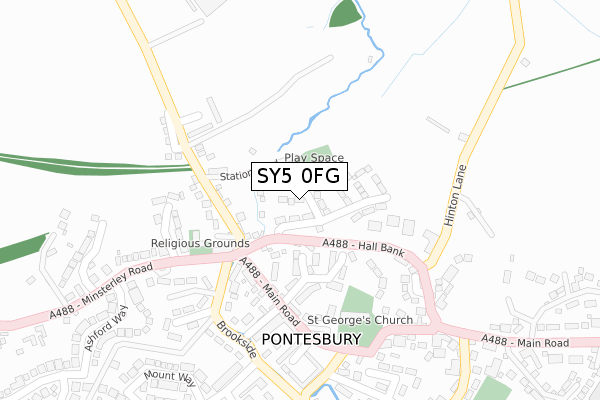
SY5 0FG is located in the Rea Valley electoral ward, within the unitary authority of Shropshire and the English Parliamentary constituency of Shrewsbury and Atcham. The Sub Integrated Care Board (ICB) Location is NHS Shropshire, Telford and Wrekin ICB - M2L0M and the police force is West Mercia. This postcode has been in use since September 2019.


GetTheData
Source: OS Open Zoomstack (Ordnance Survey)
Licence: Open Government Licence (requires attribution)
Attribution: Contains OS data © Crown copyright and database right 2025
Source: Open Postcode Geo
Licence: Open Government Licence (requires attribution)
Attribution: Contains OS data © Crown copyright and database right 2025; Contains Royal Mail data © Royal Mail copyright and database right 2025; Source: Office for National Statistics licensed under the Open Government Licence v.3.0
| Easting | 339889 |
| Northing | 306283 |
| Latitude | 52.650946 |
| Longitude | -2.889970 |
GetTheData
Source: Open Postcode Geo
Licence: Open Government Licence
| Country | England |
| Postcode District | SY5 |
➜ See where SY5 is on a map ➜ Where is Pontesbury? | |
GetTheData
Source: Land Registry Price Paid Data
Licence: Open Government Licence
| Ward | Rea Valley |
| Constituency | Shrewsbury And Atcham |
GetTheData
Source: ONS Postcode Database
Licence: Open Government Licence
2024 24 JAN £405,000 |
6, BOUNDARY WAY, PONTESBURY, SHREWSBURY, SY5 0FG 2020 6 MAR £434,950 |
3, BOUNDARY WAY, PONTESBURY, SHREWSBURY, SY5 0FG 2019 1 NOV £339,950 |
5, BOUNDARY WAY, PONTESBURY, SHREWSBURY, SY5 0FG 2019 22 OCT £394,950 |
1, BOUNDARY WAY, PONTESBURY, SHREWSBURY, SY5 0FG 2019 18 OCT £394,950 |
4, BOUNDARY WAY, PONTESBURY, SHREWSBURY, SY5 0FG 2019 20 SEP £384,950 |
2019 20 SEP £334,950 |
GetTheData
Source: HM Land Registry Price Paid Data
Licence: Contains HM Land Registry data © Crown copyright and database right 2025. This data is licensed under the Open Government Licence v3.0.
| Brooklands (Hall Bank) | Pontesbury | 72m |
| Zenna Restaurant (Main Road) | Pontesbury | 147m |
| Shop (Main Road) | Pontesbury | 256m |
| Manor Gardens Jct (Hall Bank) | Pontesbury | 270m |
| Ashford Way (Minsterley Road) | Pontesbury | 303m |
GetTheData
Source: NaPTAN
Licence: Open Government Licence
GetTheData
Source: ONS Postcode Database
Licence: Open Government Licence


➜ Get more ratings from the Food Standards Agency
GetTheData
Source: Food Standards Agency
Licence: FSA terms & conditions
| Last Collection | |||
|---|---|---|---|
| Location | Mon-Fri | Sat | Distance |
| Minsterley Road | 17:00 | 12:00 | 240m |
| Pontesbury Post Office | 17:00 | 12:00 | 251m |
| Cemetery Road | 17:15 | 09:00 | 619m |
GetTheData
Source: Dracos
Licence: Creative Commons Attribution-ShareAlike
The below table lists the International Territorial Level (ITL) codes (formerly Nomenclature of Territorial Units for Statistics (NUTS) codes) and Local Administrative Units (LAU) codes for SY5 0FG:
| ITL 1 Code | Name |
|---|---|
| TLG | West Midlands (England) |
| ITL 2 Code | Name |
| TLG2 | Shropshire and Staffordshire |
| ITL 3 Code | Name |
| TLG22 | Shropshire |
| LAU 1 Code | Name |
| E06000051 | Shropshire |
GetTheData
Source: ONS Postcode Directory
Licence: Open Government Licence
The below table lists the Census Output Area (OA), Lower Layer Super Output Area (LSOA), and Middle Layer Super Output Area (MSOA) for SY5 0FG:
| Code | Name | |
|---|---|---|
| OA | E00147558 | |
| LSOA | E01028977 | Shropshire 026E |
| MSOA | E02006039 | Shropshire 026 |
GetTheData
Source: ONS Postcode Directory
Licence: Open Government Licence
| SY5 0RH | Manor Park | 119m |
| SY5 0RF | Hall Bank | 130m |
| SY5 0QY | Station Road | 139m |
| SY5 0QU | Station Villas | 153m |
| SY5 0RR | Main Road | 165m |
| SY5 0PW | Beech Manor | 179m |
| SY5 0RQ | Ash Grove | 209m |
| SY5 0SB | Carver Street | 211m |
| SY5 0RG | Manor Gardens | 227m |
| SY5 0PP | School Bank | 229m |
GetTheData
Source: Open Postcode Geo; Land Registry Price Paid Data
Licence: Open Government Licence