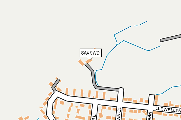
SA4 9WD is in Penllergaer, Swansea. SA4 9WD is located in the Penllergaer electoral ward, within the unitary authority of Swansea and the Welsh Parliamentary constituency of Gower. The Local Health Board is Swansea Bay University and the police force is South Wales. This postcode has been in use since June 2002.


GetTheData
Source: OS OpenMap – Local (Ordnance Survey)
Source: OS VectorMap District (Ordnance Survey)
Licence: Open Government Licence (requires attribution)
| Easting | 260782 |
| Northing | 199104 |
| Latitude | 51.673405 |
| Longitude | -4.014739 |
GetTheData
Source: Open Postcode Geo
Licence: Open Government Licence
| Locality | Penllergaer |
| Town/City | Swansea |
| Country | Wales |
| Postcode District | SA4 |
➜ See where SA4 is on a map ➜ Where is Penllergaer? | |
GetTheData
Source: Land Registry Price Paid Data
Licence: Open Government Licence
Elevation or altitude of SA4 9WD as distance above sea level:
| Metres | Feet | |
|---|---|---|
| Elevation | 60m | 197ft |
Elevation is measured from the approximate centre of the postcode, to the nearest point on an OS contour line from OS Terrain 50, which has contour spacing of ten vertical metres.
➜ How high above sea level am I? Find the elevation of your current position using your device's GPS.
GetTheData
Source: Open Postcode Elevation
Licence: Open Government Licence
| Ward | Penllergaer |
| Constituency | Gower |
GetTheData
Source: ONS Postcode Database
Licence: Open Government Licence
2021 14 MAY £315,000 |
2007 18 JUN £246,000 |
THE OLD SCHOOL, PENLLERGAER, SWANSEA, SA4 9WD 2006 27 FEB £80,000 |
THE OLD SCHOOL, PENLLERGAER, SWANSEA, SA4 9WD 2002 23 OCT £52,000 |
2000 4 OCT £100,000 |
GetTheData
Source: HM Land Registry Price Paid Data
Licence: Contains HM Land Registry data © Crown copyright and database right 2025. This data is licensed under the Open Government Licence v3.0.
| Morgan Close (Llewellyn Road) | Penllergaer | 156m |
| Llwyn-yr-eos (Heol-yr-eos) | Penllergaer | 258m |
| Heol Dewi Sant (Llewellyn Road) | Penllergaer | 408m |
| Heol Dewi Sant (Llewellyn Road) | Penllergaer | 410m |
| Club (Mount Crescent) | Penllergaer | 424m |
| Gowerton Station | 3.1km |
| Llangennech Station | 4.9km |
| Pontarddulais Station | 5.4km |
GetTheData
Source: NaPTAN
Licence: Open Government Licence
| Percentage of properties with Next Generation Access | 100.0% |
| Percentage of properties with Superfast Broadband | 0.0% |
| Percentage of properties with Ultrafast Broadband | 0.0% |
| Percentage of properties with Full Fibre Broadband | 0.0% |
Superfast Broadband is between 30Mbps and 300Mbps
Ultrafast Broadband is > 300Mbps
| Percentage of properties unable to receive 2Mbps | 0.0% |
| Percentage of properties unable to receive 5Mbps | 0.0% |
| Percentage of properties unable to receive 10Mbps | 0.0% |
| Percentage of properties unable to receive 30Mbps | 100.0% |
GetTheData
Source: Ofcom
Licence: Ofcom Terms of Use (requires attribution)
GetTheData
Source: ONS Postcode Database
Licence: Open Government Licence


➜ Get more ratings from the Food Standards Agency
GetTheData
Source: Food Standards Agency
Licence: FSA terms & conditions
| Last Collection | |||
|---|---|---|---|
| Location | Mon-Fri | Sat | Distance |
| Penllergaer P O | 18:00 | 12:15 | 591m |
| Penllergaer Po Left | 18:00 | 11:15 | 592m |
| Gorseinon Delivery Office | 18:00 | 12:45 | 787m |
GetTheData
Source: Dracos
Licence: Creative Commons Attribution-ShareAlike
The below table lists the International Territorial Level (ITL) codes (formerly Nomenclature of Territorial Units for Statistics (NUTS) codes) and Local Administrative Units (LAU) codes for SA4 9WD:
| ITL 1 Code | Name |
|---|---|
| TLL | Wales |
| ITL 2 Code | Name |
| TLL1 | West Wales and The Valleys |
| ITL 3 Code | Name |
| TLL18 | Swansea |
| LAU 1 Code | Name |
| W06000011 | Swansea |
GetTheData
Source: ONS Postcode Directory
Licence: Open Government Licence
The below table lists the Census Output Area (OA), Lower Layer Super Output Area (LSOA), and Middle Layer Super Output Area (MSOA) for SA4 9WD:
| Code | Name | |
|---|---|---|
| OA | W00004481 | |
| LSOA | W01000837 | Swansea 004D |
| MSOA | W02000171 | Swansea 004 |
GetTheData
Source: ONS Postcode Directory
Licence: Open Government Licence
| SA4 9BH | Llewellyn Road | 116m |
| SA4 9BP | Lon Einon | 197m |
| SA4 9BR | Lon Gaer | 224m |
| SA4 9BS | Heol Yr Eos | 230m |
| SA4 9BF | Morgan Close | 247m |
| SA4 9BW | Heol Y Gelli | 279m |
| SA4 9DE | Golwg Y Garn | 307m |
| SA4 9BB | Llewellyn Road | 309m |
| SA4 9WQ | Gelli Gynore Road | 326m |
| SA4 9BE | Y Garn | 343m |
GetTheData
Source: Open Postcode Geo; Land Registry Price Paid Data
Licence: Open Government Licence