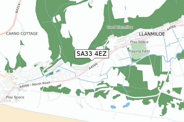
SA33 4EZ is located in the Laugharne Township electoral ward, within the unitary authority of Carmarthenshire and the Welsh Parliamentary constituency of Carmarthen West and South Pembrokeshire. The Local Health Board is Hywel Dda University and the police force is Dyfed-Powys. This postcode has been in use since June 2019.


GetTheData
Source: OS Open Zoomstack (Ordnance Survey)
Licence: Open Government Licence (requires attribution)
Attribution: Contains OS data © Crown copyright and database right 2024
Source: Open Postcode Geo
Licence: Open Government Licence (requires attribution)
Attribution: Contains OS data © Crown copyright and database right 2024; Contains Royal Mail data © Royal Mail copyright and database right 2024; Source: Office for National Statistics licensed under the Open Government Licence v.3.0
| Easting | 224659 |
| Northing | 208490 |
| Latitude | 51.747604 |
| Longitude | -4.541398 |
GetTheData
Source: Open Postcode Geo
Licence: Open Government Licence
| Country | Wales |
| Postcode District | SA33 |
➜ See where SA33 is on a map ➜ Where is Pendine? | |
GetTheData
Source: Land Registry Price Paid Data
Licence: Open Government Licence
| Ward | Laugharne Township |
| Constituency | Carmarthen West And South Pembrokeshire |
GetTheData
Source: ONS Postcode Database
Licence: Open Government Licence
4, DAN Y BRYN, PENDINE, CARMARTHEN, SA33 4EZ 2022 2 SEP £97,500 |
6, DAN Y BRYN, PENDINE, CARMARTHEN, SA33 4EZ 2022 22 JUN £120,000 |
14, DAN Y BRYN, PENDINE, CARMARTHEN, SA33 4EZ 2022 16 JUN £90,000 |
23, DAN Y BRYN, PENDINE, CARMARTHEN, SA33 4EZ 2022 26 MAY £92,500 |
19, DAN Y BRYN, PENDINE, CARMARTHEN, SA33 4EZ 2022 24 MAR £80,000 |
26, DAN Y BRYN, PENDINE, CARMARTHEN, SA33 4EZ 2021 24 NOV £97,500 |
3, DAN Y BRYN, PENDINE, CARMARTHEN, SA33 4EZ 2021 18 OCT £87,500 |
22, DAN Y BRYN, PENDINE, CARMARTHEN, SA33 4EZ 2021 1 OCT £82,500 |
21, DAN Y BRYN, PENDINE, CARMARTHEN, SA33 4EZ 2021 7 MAY £82,500 |
2021 1 FEB £75,000 |
GetTheData
Source: HM Land Registry Price Paid Data
Licence: Contains HM Land Registry data © Crown copyright and database right 2024. This data is licensed under the Open Government Licence v3.0.
| Woodend (A4066) | Llanmiloe | 64m |
| Woodend (A4066) | Llanmiloe | 68m |
| Social Club (A4066) | Llanmiloe | 403m |
| Social Club (A4066) | Llanmiloe | 404m |
| Cysgod-y-coed (A4066) | Llanmiloe | 515m |
GetTheData
Source: NaPTAN
Licence: Open Government Licence
GetTheData
Source: ONS Postcode Database
Licence: Open Government Licence


➜ Get more ratings from the Food Standards Agency
GetTheData
Source: Food Standards Agency
Licence: FSA terms & conditions
The below table lists the International Territorial Level (ITL) codes (formerly Nomenclature of Territorial Units for Statistics (NUTS) codes) and Local Administrative Units (LAU) codes for SA33 4EZ:
| ITL 1 Code | Name |
|---|---|
| TLL | Wales |
| ITL 2 Code | Name |
| TLL1 | West Wales and The Valleys |
| ITL 3 Code | Name |
| TLL14 | South West Wales |
| LAU 1 Code | Name |
| W06000010 | Carmarthenshire |
GetTheData
Source: ONS Postcode Directory
Licence: Open Government Licence
The below table lists the Census Output Area (OA), Lower Layer Super Output Area (LSOA), and Middle Layer Super Output Area (MSOA) for SA33 4EZ:
| Code | Name | |
|---|---|---|
| OA | W00003621 | |
| LSOA | W01000672 | Carmarthenshire 027E |
| MSOA | W02000418 | Carmarthenshire 027 |
GetTheData
Source: ONS Postcode Directory
Licence: Open Government Licence
| SA33 4UB | Llanmiloe Bach | 116m |
| SA33 4UG | Wood End | 218m |
| SA33 4UF | Llanmiloe Estate | 470m |
| SA33 4UH | Dukes Meadow | 574m |
| SA33 4UE | Llanmiloe Estate | 682m |
| SA33 4TW | Cysgod Y Coed | 707m |
| SA33 4PE | 1119m | |
| SA33 4PF | 1139m | |
| SA33 4NY | 1290m | |
| SA33 4PD | 1304m |
GetTheData
Source: Open Postcode Geo; Land Registry Price Paid Data
Licence: Open Government Licence