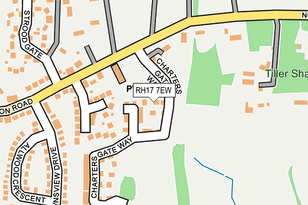
RH17 7EW is located in the Wivelsfield electoral ward, within the local authority district of Lewes and the English Parliamentary constituency of Lewes. The Sub Integrated Care Board (ICB) Location is NHS Sussex ICB - 97R and the police force is Sussex. This postcode has been in use since March 2017.


GetTheData
Source: OS OpenMap – Local (Ordnance Survey)
Source: OS VectorMap District (Ordnance Survey)
Licence: Open Government Licence (requires attribution)
| Easting | 535642 |
| Northing | 119929 |
| Latitude | 50.962821 |
| Longitude | -0.069812 |
GetTheData
Source: Open Postcode Geo
Licence: Open Government Licence
| Country | England |
| Postcode District | RH17 |
➜ See where RH17 is on a map ➜ Where is Wivelsfield Green? | |
GetTheData
Source: Land Registry Price Paid Data
Licence: Open Government Licence
| Ward | Wivelsfield |
| Constituency | Lewes |
GetTheData
Source: ONS Postcode Database
Licence: Open Government Licence
2024 5 MAR £565,000 |
2024 8 JAN £795,000 |
2023 2 NOV £755,000 |
2023 19 JUL £780,000 |
2022 30 NOV £625,000 |
2022 11 OCT £585,000 |
2022 12 SEP £675,000 |
2022 26 AUG £805,000 |
2021 30 APR £642,500 |
2020 26 JUN £478,500 |
➜ Wivelsfield Green house prices
GetTheData
Source: HM Land Registry Price Paid Data
Licence: Contains HM Land Registry data © Crown copyright and database right 2025. This data is licensed under the Open Government Licence v3.0.
| Downsview Drive (South Road) | Wivelsfield Green | 276m |
| Downsview Drive (South Road) | Wivelsfield Green | 292m |
| Coppards Close (South Road) | Wivelsfield Green | 384m |
| Coppards Close (South Road) | Wivelsfield Green | 399m |
| Primary School (School Grounds) | Wivelsfield Green | 436m |
| Wivelsfield Station | 3.6km |
| Plumpton Station | 3.9km |
| Burgess Hill Station | 4.2km |
GetTheData
Source: NaPTAN
Licence: Open Government Licence
| Percentage of properties with Next Generation Access | 100.0% |
| Percentage of properties with Superfast Broadband | 100.0% |
| Percentage of properties with Ultrafast Broadband | 0.0% |
| Percentage of properties with Full Fibre Broadband | 0.0% |
Superfast Broadband is between 30Mbps and 300Mbps
Ultrafast Broadband is > 300Mbps
| Median download speed | 62.0Mbps |
| Average download speed | 59.1Mbps |
| Maximum download speed | 80.00Mbps |
| Median upload speed | 16.2Mbps |
| Average upload speed | 14.0Mbps |
| Maximum upload speed | 20.00Mbps |
| Percentage of properties unable to receive 2Mbps | 0.0% |
| Percentage of properties unable to receive 5Mbps | 0.0% |
| Percentage of properties unable to receive 10Mbps | 0.0% |
| Percentage of properties unable to receive 30Mbps | 0.0% |
GetTheData
Source: Ofcom
Licence: Ofcom Terms of Use (requires attribution)
GetTheData
Source: ONS Postcode Database
Licence: Open Government Licence


➜ Get more ratings from the Food Standards Agency
GetTheData
Source: Food Standards Agency
Licence: FSA terms & conditions
| Last Collection | |||
|---|---|---|---|
| Location | Mon-Fri | Sat | Distance |
| Crossways | 16:00 | 07:00 | 2,046m |
| St Georges Park | 17:00 | 11:15 | 2,063m |
| Streat Lane | 16:15 | 08:15 | 2,320m |
GetTheData
Source: Dracos
Licence: Creative Commons Attribution-ShareAlike
The below table lists the International Territorial Level (ITL) codes (formerly Nomenclature of Territorial Units for Statistics (NUTS) codes) and Local Administrative Units (LAU) codes for RH17 7EW:
| ITL 1 Code | Name |
|---|---|
| TLJ | South East (England) |
| ITL 2 Code | Name |
| TLJ2 | Surrey, East and West Sussex |
| ITL 3 Code | Name |
| TLJ22 | East Sussex CC |
| LAU 1 Code | Name |
| E07000063 | Lewes |
GetTheData
Source: ONS Postcode Directory
Licence: Open Government Licence
The below table lists the Census Output Area (OA), Lower Layer Super Output Area (LSOA), and Middle Layer Super Output Area (MSOA) for RH17 7EW:
| Code | Name | |
|---|---|---|
| OA | E00106783 | |
| LSOA | E01021023 | Lewes 002A |
| MSOA | E02004380 | Lewes 002 |
GetTheData
Source: ONS Postcode Directory
Licence: Open Government Licence
| RH17 7RA | Farncombe Close | 91m |
| RH17 7RN | Downsview Drive | 161m |
| RH17 7RW | Downsview Drive | 187m |
| RH17 7RJ | North Common Road | 207m |
| RH17 7RP | Allwood Crescent | 233m |
| RH17 7RY | Strood Gate | 278m |
| RH17 7RH | North Common Road | 283m |
| RH17 7QW | Coppards Close | 324m |
| RH17 7QS | South Road | 325m |
| RH17 7QR | Fair Place | 327m |
GetTheData
Source: Open Postcode Geo; Land Registry Price Paid Data
Licence: Open Government Licence