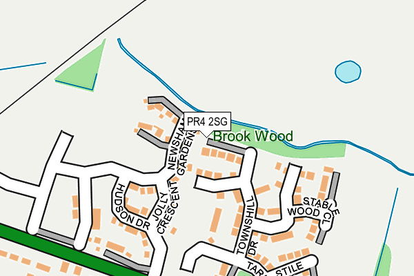
PR4 2SG is located in the Kirkham electoral ward, within the local authority district of Fylde and the English Parliamentary constituency of Fylde. The Sub Integrated Care Board (ICB) Location is NHS Lancashire and South Cumbria ICB - 02M and the police force is Lancashire. This postcode has been in use since July 2017.


GetTheData
Source: OS OpenMap – Local (Ordnance Survey)
Source: OS VectorMap District (Ordnance Survey)
Licence: Open Government Licence (requires attribution)
| Easting | 340886 |
| Northing | 432462 |
| Latitude | 53.785122 |
| Longitude | -2.898669 |
GetTheData
Source: Open Postcode Geo
Licence: Open Government Licence
| Country | England |
| Postcode District | PR4 |
➜ See where PR4 is on a map ➜ Where is Kirkham? | |
GetTheData
Source: Land Registry Price Paid Data
Licence: Open Government Licence
| Ward | Kirkham |
| Constituency | Fylde |
GetTheData
Source: ONS Postcode Database
Licence: Open Government Licence
2023 27 JAN £415,000 |
2022 26 AUG £375,000 |
2022 17 AUG £420,000 |
2022 1 JUL £370,000 |
2021 20 AUG £360,000 |
20, TOWNSHILL DRIVE, KIRKHAM, PRESTON, PR4 2SG 2019 14 JUN £339,995 |
18, TOWNSHILL DRIVE, KIRKHAM, PRESTON, PR4 2SG 2018 9 AUG £334,995 |
14, TOWNSHILL DRIVE, KIRKHAM, PRESTON, PR4 2SG 2018 2 MAR £389,995 |
2018 2 MAR £359,995 |
15, TOWNSHILL DRIVE, KIRKHAM, PRESTON, PR4 2SG 2018 26 JAN £304,995 |
GetTheData
Source: HM Land Registry Price Paid Data
Licence: Contains HM Land Registry data © Crown copyright and database right 2024. This data is licensed under the Open Government Licence v3.0.
| Kingfisher (St Georges Park) | Kirkham | 435m |
| Ribby Hall Entrance (Ribby Road) | Wrea Green | 520m |
| Ribby Hall Entrance (Ribby Road) | Wrea Green | 569m |
| Grammar School (Ribby Road) | Kirkham | 879m |
| Everest Court (Market Street) | Wesham | 883m |
| Kirkham & Wesham Station | 1.1km |
| Moss Side Station | 3.7km |
GetTheData
Source: NaPTAN
Licence: Open Government Licence
| Percentage of properties with Next Generation Access | 100.0% |
| Percentage of properties with Superfast Broadband | 100.0% |
| Percentage of properties with Ultrafast Broadband | 100.0% |
| Percentage of properties with Full Fibre Broadband | 100.0% |
Superfast Broadband is between 30Mbps and 300Mbps
Ultrafast Broadband is > 300Mbps
| Percentage of properties unable to receive 2Mbps | 0.0% |
| Percentage of properties unable to receive 5Mbps | 0.0% |
| Percentage of properties unable to receive 10Mbps | 0.0% |
| Percentage of properties unable to receive 30Mbps | 0.0% |
GetTheData
Source: Ofcom
Licence: Ofcom Terms of Use (requires attribution)
GetTheData
Source: ONS Postcode Database
Licence: Open Government Licence


➜ Get more ratings from the Food Standards Agency
GetTheData
Source: Food Standards Agency
Licence: FSA terms & conditions
| Last Collection | |||
|---|---|---|---|
| Location | Mon-Fri | Sat | Distance |
| Wesham Post Office | 17:00 | 09:45 | 957m |
| Wesham Cross | 17:00 | 09:45 | 1,106m |
| Sunnybank | 17:30 | 09:45 | 1,144m |
GetTheData
Source: Dracos
Licence: Creative Commons Attribution-ShareAlike
The below table lists the International Territorial Level (ITL) codes (formerly Nomenclature of Territorial Units for Statistics (NUTS) codes) and Local Administrative Units (LAU) codes for PR4 2SG:
| ITL 1 Code | Name |
|---|---|
| TLD | North West (England) |
| ITL 2 Code | Name |
| TLD4 | Lancashire |
| ITL 3 Code | Name |
| TLD45 | Mid Lancashire |
| LAU 1 Code | Name |
| E07000119 | Fylde |
GetTheData
Source: ONS Postcode Directory
Licence: Open Government Licence
The below table lists the Census Output Area (OA), Lower Layer Super Output Area (LSOA), and Middle Layer Super Output Area (MSOA) for PR4 2SG:
| Code | Name | |
|---|---|---|
| OA | E00126929 | |
| LSOA | E01025007 | Fylde 002A |
| MSOA | E02005204 | Fylde 002 |
GetTheData
Source: ONS Postcode Directory
Licence: Open Government Licence
| PR4 2SF | Stile Close | 149m |
| PR4 2RD | Blackpool Road | 280m |
| PR4 2RE | Blackpool Road | 369m |
| PR4 2DU | Springfield Avenue | 388m |
| PR4 2EB | Firfield Close | 401m |
| PR4 2EE | Sandown Close | 430m |
| PR4 2DS | Foxwood Drive | 483m |
| PR4 2ED | Long Meadow | 484m |
| PR4 2DZ | St Georges Park | 490m |
| PR4 2DX | Regency Crescent | 547m |
GetTheData
Source: Open Postcode Geo; Land Registry Price Paid Data
Licence: Open Government Licence