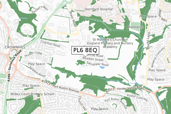
PL6 8EQ is located in the Moor View electoral ward, within the unitary authority of Plymouth and the English Parliamentary constituency of Plymouth, Moor View. The Sub Integrated Care Board (ICB) Location is NHS Devon ICB - 15N and the police force is Devon & Cornwall. This postcode has been in use since December 2017.


GetTheData
Source: OS Open Zoomstack (Ordnance Survey)
Licence: Open Government Licence (requires attribution)
Attribution: Contains OS data © Crown copyright and database right 2025
Source: Open Postcode Geo
Licence: Open Government Licence (requires attribution)
Attribution: Contains OS data © Crown copyright and database right 2025; Contains Royal Mail data © Royal Mail copyright and database right 2025; Source: Office for National Statistics licensed under the Open Government Licence v.3.0
| Easting | 249587 |
| Northing | 58822 |
| Latitude | 50.409951 |
| Longitude | -4.118239 |
GetTheData
Source: Open Postcode Geo
Licence: Open Government Licence
| Country | England |
| Postcode District | PL6 |
➜ See where PL6 is on a map ➜ Where is Plymouth? | |
GetTheData
Source: Land Registry Price Paid Data
Licence: Open Government Licence
| Ward | Moor View |
| Constituency | Plymouth, Moor View |
GetTheData
Source: ONS Postcode Database
Licence: Open Government Licence
105, BLUEBELL STREET, PLYMOUTH, PL6 8EQ 2019 30 SEP £179,995 |
109, BLUEBELL STREET, PLYMOUTH, PL6 8EQ 2019 27 SEP £260,000 |
GetTheData
Source: HM Land Registry Price Paid Data
Licence: Contains HM Land Registry data © Crown copyright and database right 2025. This data is licensed under the Open Government Licence v3.0.
| Brest Road South (Brest Road) | Derriford | 195m |
| Bircham House (Brest Road) | Derriford | 268m |
| South West Media (Brest Road) | Derriford | 352m |
| Peninsular Radiology (William Prance Road) | Derriford | 363m |
| Peninsular Radiology | Derriford | 436m |
| Plymouth Station | 4km |
| Keyham Station | 4.9km |
| St Budeaux Ferry Road Station | 5km |
GetTheData
Source: NaPTAN
Licence: Open Government Licence
| Percentage of properties with Next Generation Access | 100.0% |
| Percentage of properties with Superfast Broadband | 100.0% |
| Percentage of properties with Ultrafast Broadband | 100.0% |
| Percentage of properties with Full Fibre Broadband | 100.0% |
Superfast Broadband is between 30Mbps and 300Mbps
Ultrafast Broadband is > 300Mbps
| Percentage of properties unable to receive 2Mbps | 0.0% |
| Percentage of properties unable to receive 5Mbps | 0.0% |
| Percentage of properties unable to receive 10Mbps | 0.0% |
| Percentage of properties unable to receive 30Mbps | 0.0% |
GetTheData
Source: Ofcom
Licence: Ofcom Terms of Use (requires attribution)
GetTheData
Source: ONS Postcode Database
Licence: Open Government Licence


➜ Get more ratings from the Food Standards Agency
GetTheData
Source: Food Standards Agency
Licence: FSA terms & conditions
| Last Collection | |||
|---|---|---|---|
| Location | Mon-Fri | Sat | Distance |
| Penrith Gardens | 17:15 | 12:30 | 929m |
| Erlstoke Close | 17:30 | 12:30 | 1,032m |
| Crownhill Post Office | 18:15 | 12:00 | 1,086m |
GetTheData
Source: Dracos
Licence: Creative Commons Attribution-ShareAlike
The below table lists the International Territorial Level (ITL) codes (formerly Nomenclature of Territorial Units for Statistics (NUTS) codes) and Local Administrative Units (LAU) codes for PL6 8EQ:
| ITL 1 Code | Name |
|---|---|
| TLK | South West (England) |
| ITL 2 Code | Name |
| TLK4 | Devon |
| ITL 3 Code | Name |
| TLK41 | Plymouth |
| LAU 1 Code | Name |
| E06000026 | Plymouth |
GetTheData
Source: ONS Postcode Directory
Licence: Open Government Licence
The below table lists the Census Output Area (OA), Lower Layer Super Output Area (LSOA), and Middle Layer Super Output Area (MSOA) for PL6 8EQ:
| Code | Name | |
|---|---|---|
| OA | E00076259 | |
| LSOA | E01015092 | Plymouth 005C |
| MSOA | E02003126 | Plymouth 005 |
GetTheData
Source: ONS Postcode Directory
Licence: Open Government Licence
| PL6 8EF | Buttercup Road | 83m |
| PL6 8EG | Cornflower Walk | 140m |
| PL6 8DY | Bluebell Street | 227m |
| PL6 5XN | Brest Road | 442m |
| PL6 5NT | Fort Austin Avenue | 495m |
| PL6 5FB | Smallack Drive | 513m |
| PL6 5NS | Fort Austin Avenue | 534m |
| PL6 5EE | Richmond Road | 540m |
| PL6 5EG | Charlton Road | 540m |
| PL6 5NR | Fort Austin Avenue | 540m |
GetTheData
Source: Open Postcode Geo; Land Registry Price Paid Data
Licence: Open Government Licence