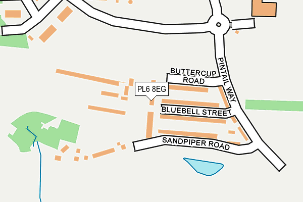
PL6 8EG lies on Cornflower Walk in Plymouth. PL6 8EG is located in the Moor View electoral ward, within the unitary authority of Plymouth and the English Parliamentary constituency of Plymouth, Moor View. The Sub Integrated Care Board (ICB) Location is NHS Devon ICB - 15N and the police force is Devon & Cornwall. This postcode has been in use since March 2017.


GetTheData
Source: OS OpenMap – Local (Ordnance Survey)
Source: OS VectorMap District (Ordnance Survey)
Licence: Open Government Licence (requires attribution)
| Easting | 249719 |
| Northing | 58775 |
| Latitude | 50.409562 |
| Longitude | -4.116364 |
GetTheData
Source: Open Postcode Geo
Licence: Open Government Licence
| Street | Cornflower Walk |
| Town/City | Plymouth |
| Country | England |
| Postcode District | PL6 |
➜ See where PL6 is on a map ➜ Where is Plymouth? | |
GetTheData
Source: Land Registry Price Paid Data
Licence: Open Government Licence
| Ward | Moor View |
| Constituency | Plymouth, Moor View |
GetTheData
Source: ONS Postcode Database
Licence: Open Government Licence
6, CORNFLOWER WALK, PLYMOUTH, PL6 8EG 2022 10 JAN £369,995 |
14, CORNFLOWER WALK, PLYMOUTH, PL6 8EG 2018 21 DEC £299,995 |
16, CORNFLOWER WALK, PLYMOUTH, PL6 8EG 2018 29 MAR £312,000 |
8, CORNFLOWER WALK, PLYMOUTH, PL6 8EG 2017 22 DEC £312,000 |
GetTheData
Source: HM Land Registry Price Paid Data
Licence: Contains HM Land Registry data © Crown copyright and database right 2025. This data is licensed under the Open Government Licence v3.0.
| Brest Road South (Brest Road) | Derriford | 164m |
| Bircham House (Brest Road) | Derriford | 372m |
| South West Media (Brest Road) | Derriford | 386m |
| Peninsular Radiology (William Prance Road) | Derriford | 476m |
| Fort Austin Garden Centre (Fort Austin Avenue) | Eggbuckland | 509m |
| Plymouth Station | 4km |
| Keyham Station | 5km |
| Devonport Station | 5.2km |
GetTheData
Source: NaPTAN
Licence: Open Government Licence
| Percentage of properties with Next Generation Access | 100.0% |
| Percentage of properties with Superfast Broadband | 100.0% |
| Percentage of properties with Ultrafast Broadband | 100.0% |
| Percentage of properties with Full Fibre Broadband | 100.0% |
Superfast Broadband is between 30Mbps and 300Mbps
Ultrafast Broadband is > 300Mbps
| Median download speed | 4.5Mbps |
| Average download speed | 4.4Mbps |
| Maximum download speed | 5.60Mbps |
| Median upload speed | 0.6Mbps |
| Average upload speed | 0.6Mbps |
| Maximum upload speed | 0.78Mbps |
| Percentage of properties unable to receive 2Mbps | 0.0% |
| Percentage of properties unable to receive 5Mbps | 0.0% |
| Percentage of properties unable to receive 10Mbps | 0.0% |
| Percentage of properties unable to receive 30Mbps | 0.0% |
GetTheData
Source: Ofcom
Licence: Ofcom Terms of Use (requires attribution)
GetTheData
Source: ONS Postcode Database
Licence: Open Government Licence


➜ Get more ratings from the Food Standards Agency
GetTheData
Source: Food Standards Agency
Licence: FSA terms & conditions
| Last Collection | |||
|---|---|---|---|
| Location | Mon-Fri | Sat | Distance |
| Penrith Gardens | 17:15 | 12:30 | 880m |
| Erlstoke Close | 17:30 | 12:30 | 901m |
| Langdale Gardens | 17:00 | 12:00 | 1,042m |
GetTheData
Source: Dracos
Licence: Creative Commons Attribution-ShareAlike
The below table lists the International Territorial Level (ITL) codes (formerly Nomenclature of Territorial Units for Statistics (NUTS) codes) and Local Administrative Units (LAU) codes for PL6 8EG:
| ITL 1 Code | Name |
|---|---|
| TLK | South West (England) |
| ITL 2 Code | Name |
| TLK4 | Devon |
| ITL 3 Code | Name |
| TLK41 | Plymouth |
| LAU 1 Code | Name |
| E06000026 | Plymouth |
GetTheData
Source: ONS Postcode Directory
Licence: Open Government Licence
The below table lists the Census Output Area (OA), Lower Layer Super Output Area (LSOA), and Middle Layer Super Output Area (MSOA) for PL6 8EG:
| Code | Name | |
|---|---|---|
| OA | E00076259 | |
| LSOA | E01015092 | Plymouth 005C |
| MSOA | E02003126 | Plymouth 005 |
GetTheData
Source: ONS Postcode Directory
Licence: Open Government Licence
| PL6 8EF | Buttercup Road | 83m |
| PL6 8DY | Bluebell Street | 88m |
| PL6 5WP | Austin Crescent | 502m |
| PL6 5NT | Fort Austin Avenue | 514m |
| PL6 5XN | Brest Road | 515m |
| PL6 5WE | Ducane Walk | 528m |
| PL6 5NU | Fort Austin Avenue | 531m |
| PL6 5NS | Fort Austin Avenue | 545m |
| PL6 5QR | Forder Valley Road | 562m |
| PL6 5RA | Church Hill | 570m |
GetTheData
Source: Open Postcode Geo; Land Registry Price Paid Data
Licence: Open Government Licence