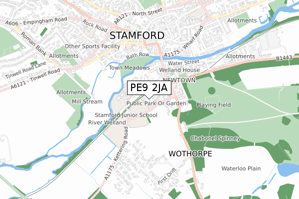
PE9 2JA is located in the Stamford St Mary's electoral ward, within the local authority district of South Kesteven and the English Parliamentary constituency of Grantham and Stamford. The Sub Integrated Care Board (ICB) Location is NHS Lincolnshire ICB - 71E and the police force is Lincolnshire. This postcode has been in use since February 2018.


GetTheData
Source: OS Open Zoomstack (Ordnance Survey)
Licence: Open Government Licence (requires attribution)
Attribution: Contains OS data © Crown copyright and database right 2025
Source: Open Postcode Geo
Licence: Open Government Licence (requires attribution)
Attribution: Contains OS data © Crown copyright and database right 2025; Contains Royal Mail data © Royal Mail copyright and database right 2025; Source: Office for National Statistics licensed under the Open Government Licence v.3.0
| Easting | 502973 |
| Northing | 306598 |
| Latitude | 52.647373 |
| Longitude | -0.479411 |
GetTheData
Source: Open Postcode Geo
Licence: Open Government Licence
| Country | England |
| Postcode District | PE9 |
➜ See where PE9 is on a map ➜ Where is Stamford? | |
GetTheData
Source: Land Registry Price Paid Data
Licence: Open Government Licence
| Ward | Stamford St Mary's |
| Constituency | Grantham And Stamford |
GetTheData
Source: ONS Postcode Database
Licence: Open Government Licence
2023 13 NOV £875,000 |
2022 23 AUG £1,215,000 |
2022 25 FEB £695,000 |
2021 28 JUN £725,000 |
47, HEREWARD PLACE, STAMFORD, PE9 2JA 2020 30 APR £615,000 |
2020 24 JAN £774,500 |
2019 4 NOV £699,500 |
51, HEREWARD PLACE, STAMFORD, PE9 2JA 2019 11 OCT £630,000 |
16, HEREWARD PLACE, STAMFORD, PE9 2JA 2019 30 AUG £674,500 |
45, HEREWARD PLACE, STAMFORD, PE9 2JA 2019 26 JUL £1,000,000 |
GetTheData
Source: HM Land Registry Price Paid Data
Licence: Contains HM Land Registry data © Crown copyright and database right 2025. This data is licensed under the Open Government Licence v3.0.
| High School (High Street St Martin's) | Stamford | 180m |
| High School (High Street St Martin's) | Stamford | 192m |
| St Marys Medical Centre (Wharf Road) | Stamford | 381m |
| St Marys Medical Centre (Wharf Road) | Stamford | 388m |
| Phillips Court (Water Street) | Stamford | 466m |
| Stamford Station | 0.1km |
GetTheData
Source: NaPTAN
Licence: Open Government Licence
| Percentage of properties with Next Generation Access | 100.0% |
| Percentage of properties with Superfast Broadband | 100.0% |
| Percentage of properties with Ultrafast Broadband | 0.0% |
| Percentage of properties with Full Fibre Broadband | 0.0% |
Superfast Broadband is between 30Mbps and 300Mbps
Ultrafast Broadband is > 300Mbps
| Median download speed | 55.0Mbps |
| Average download speed | 54.7Mbps |
| Maximum download speed | 70.28Mbps |
| Median upload speed | 14.3Mbps |
| Average upload speed | 14.6Mbps |
| Maximum upload speed | 20.00Mbps |
| Percentage of properties unable to receive 2Mbps | 0.0% |
| Percentage of properties unable to receive 5Mbps | 0.0% |
| Percentage of properties unable to receive 10Mbps | 0.0% |
| Percentage of properties unable to receive 30Mbps | 0.0% |
GetTheData
Source: Ofcom
Licence: Ofcom Terms of Use (requires attribution)
GetTheData
Source: ONS Postcode Database
Licence: Open Government Licence


➜ Get more ratings from the Food Standards Agency
GetTheData
Source: Food Standards Agency
Licence: FSA terms & conditions
| Last Collection | |||
|---|---|---|---|
| Location | Mon-Fri | Sat | Distance |
| Railway Station | 17:30 | 11:30 | 79m |
| St Martins | 17:30 | 11:15 | 296m |
| St Marys Street | 17:30 | 12:15 | 461m |
GetTheData
Source: Dracos
Licence: Creative Commons Attribution-ShareAlike
The below table lists the International Territorial Level (ITL) codes (formerly Nomenclature of Territorial Units for Statistics (NUTS) codes) and Local Administrative Units (LAU) codes for PE9 2JA:
| ITL 1 Code | Name |
|---|---|
| TLF | East Midlands (England) |
| ITL 2 Code | Name |
| TLF3 | Lincolnshire |
| ITL 3 Code | Name |
| TLF30 | Lincolnshire CC |
| LAU 1 Code | Name |
| E07000141 | South Kesteven |
GetTheData
Source: ONS Postcode Directory
Licence: Open Government Licence
The below table lists the Census Output Area (OA), Lower Layer Super Output Area (LSOA), and Middle Layer Super Output Area (MSOA) for PE9 2JA:
| Code | Name | |
|---|---|---|
| OA | E00133842 | |
| LSOA | E01026350 | South Kesteven 016B |
| MSOA | E02005491 | South Kesteven 016 |
GetTheData
Source: ONS Postcode Directory
Licence: Open Government Licence
| PE9 2LR | Kettering Road | 78m |
| PE9 2JR | Wothorpe Road | 111m |
| PE9 2ZD | Garratt Road | 114m |
| PE9 2JU | Church Lane | 125m |
| PE9 2GA | Wothorpe Mews | 139m |
| PE9 2ZA | Gresley Drive | 151m |
| PE9 2ZE | Mallard Court | 154m |
| PE9 2LS | Pinfold Lane | 156m |
| PE9 2ZF | Seaton Road | 158m |
| PE9 2JX | Church Street | 158m |
GetTheData
Source: Open Postcode Geo; Land Registry Price Paid Data
Licence: Open Government Licence