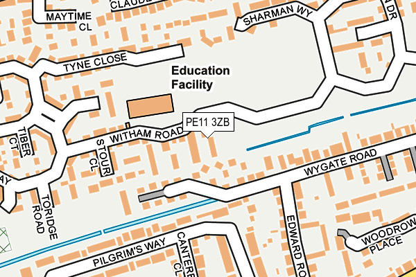
PE11 3ZB is located in the Spalding Wygate electoral ward, within the local authority district of South Holland and the English Parliamentary constituency of South Holland and The Deepings. The Sub Integrated Care Board (ICB) Location is NHS Lincolnshire ICB - 71E and the police force is Lincolnshire. This postcode has been in use since April 2017.


GetTheData
Source: OS OpenMap – Local (Ordnance Survey)
Source: OS VectorMap District (Ordnance Survey)
Licence: Open Government Licence (requires attribution)
| Easting | 523525 |
| Northing | 322947 |
| Latitude | 52.789986 |
| Longitude | -0.169653 |
GetTheData
Source: Open Postcode Geo
Licence: Open Government Licence
| Country | England |
| Postcode District | PE11 |
➜ See where PE11 is on a map ➜ Where is Spalding? | |
GetTheData
Source: Land Registry Price Paid Data
Licence: Open Government Licence
| Ward | Spalding Wygate |
| Constituency | South Holland And The Deepings |
GetTheData
Source: ONS Postcode Database
Licence: Open Government Licence
2024 13 DEC £188,000 |
2021 6 AUG £220,000 |
2017 23 JUN £207,000 |
2, WAVENEY CLOSE, SPALDING, PE11 3ZB 2017 13 APR £206,000 |
2017 13 APR £170,995 |
GetTheData
Source: HM Land Registry Price Paid Data
Licence: Contains HM Land Registry data © Crown copyright and database right 2025. This data is licensed under the Open Government Licence v3.0.
| Junction With Pennygate (Edward Road) | Spalding | 239m |
| 125 Wygate Road (Wygate Road) | Spalding | 240m |
| 125 Wygate Road (Wygate Road) | Spalding | 247m |
| Junction With Pennygate (Edward Road) | Spalding | 295m |
| Avignon Road (Estella Way) | Spalding | 305m |
| Spalding Station | 0.9km |
GetTheData
Source: NaPTAN
Licence: Open Government Licence
| Percentage of properties with Next Generation Access | 0.0% |
| Percentage of properties with Superfast Broadband | 0.0% |
| Percentage of properties with Ultrafast Broadband | 0.0% |
| Percentage of properties with Full Fibre Broadband | 0.0% |
Superfast Broadband is between 30Mbps and 300Mbps
Ultrafast Broadband is > 300Mbps
| Median download speed | 3.0Mbps |
| Average download speed | 3.2Mbps |
| Maximum download speed | 4.91Mbps |
| Median upload speed | 0.6Mbps |
| Average upload speed | 0.6Mbps |
| Maximum upload speed | 0.78Mbps |
| Percentage of properties unable to receive 2Mbps | 0.0% |
| Percentage of properties unable to receive 5Mbps | 100.0% |
| Percentage of properties unable to receive 10Mbps | 100.0% |
| Percentage of properties unable to receive 30Mbps | 100.0% |
GetTheData
Source: Ofcom
Licence: Ofcom Terms of Use (requires attribution)
GetTheData
Source: ONS Postcode Database
Licence: Open Government Licence


➜ Get more ratings from the Food Standards Agency
GetTheData
Source: Food Standards Agency
Licence: FSA terms & conditions
| Last Collection | |||
|---|---|---|---|
| Location | Mon-Fri | Sat | Distance |
| Westlode Street | 17:45 | 12:00 | 1,199m |
| Horseshoe Road Bridge | 16:00 | 11:00 | 2,334m |
| Fern Drive | 17:30 | 12:00 | 2,740m |
GetTheData
Source: Dracos
Licence: Creative Commons Attribution-ShareAlike
| Risk of PE11 3ZB flooding from rivers and sea | Medium |
| ➜ PE11 3ZB flood map | |
GetTheData
Source: Open Flood Risk by Postcode
Licence: Open Government Licence
The below table lists the International Territorial Level (ITL) codes (formerly Nomenclature of Territorial Units for Statistics (NUTS) codes) and Local Administrative Units (LAU) codes for PE11 3ZB:
| ITL 1 Code | Name |
|---|---|
| TLF | East Midlands (England) |
| ITL 2 Code | Name |
| TLF3 | Lincolnshire |
| ITL 3 Code | Name |
| TLF30 | Lincolnshire CC |
| LAU 1 Code | Name |
| E07000140 | South Holland |
GetTheData
Source: ONS Postcode Directory
Licence: Open Government Licence
The below table lists the Census Output Area (OA), Lower Layer Super Output Area (LSOA), and Middle Layer Super Output Area (MSOA) for PE11 3ZB:
| Code | Name | |
|---|---|---|
| OA | E00169389 | |
| LSOA | E01026275 | South Holland 006E |
| MSOA | E02005470 | South Holland 006 |
GetTheData
Source: ONS Postcode Directory
Licence: Open Government Licence
| PE11 1NZ | Betjeman Close | 42m |
| PE11 3WT | Witham Road | 59m |
| PE11 1NQ | Laureate Grove | 63m |
| PE11 1NY | Wygate Road | 78m |
| PE11 3WZ | Stour Close | 139m |
| PE11 3WW | Medina Walk | 161m |
| PE11 3DN | Tyne Close | 177m |
| PE11 1LL | Canterbury Close | 178m |
| PE11 1NP | Edward Road | 191m |
| PE11 3WB | Danube Square | 198m |
GetTheData
Source: Open Postcode Geo; Land Registry Price Paid Data
Licence: Open Government Licence