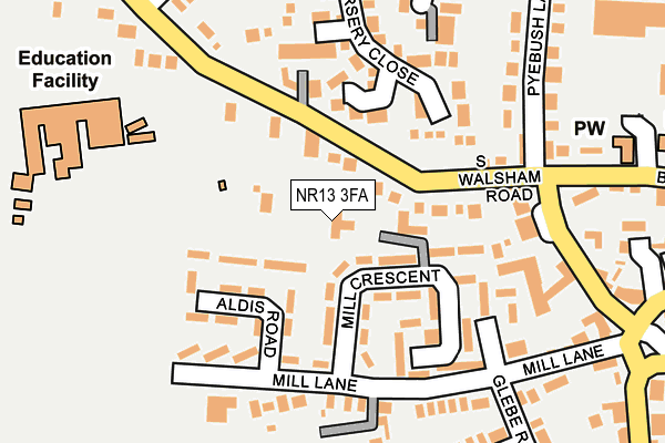
NR13 3FA is located in the Acle electoral ward, within the local authority district of Broadland and the English Parliamentary constituency of Broadland. The Sub Integrated Care Board (ICB) Location is NHS Norfolk and Waveney ICB - 26A and the police force is Norfolk. This postcode has been in use since April 2017.


GetTheData
Source: OS OpenMap – Local (Ordnance Survey)
Source: OS VectorMap District (Ordnance Survey)
Licence: Open Government Licence (requires attribution)
| Easting | 640651 |
| Northing | 310572 |
| Latitude | 52.639506 |
| Longitude | 1.555431 |
GetTheData
Source: Open Postcode Geo
Licence: Open Government Licence
| Country | England |
| Postcode District | NR13 |
➜ See where NR13 is on a map ➜ Where is Acle? | |
GetTheData
Source: Land Registry Price Paid Data
Licence: Open Government Licence
| Ward | Acle |
| Constituency | Broadland |
GetTheData
Source: ONS Postcode Database
Licence: Open Government Licence
2023 14 AUG £321,500 |
2020 18 DEC £267,500 |
7, OAKS LEA, ACLE, NORWICH, NR13 3FA 2019 8 NOV £335,000 |
13, OAKS LEA, ACLE, NORWICH, NR13 3FA 2019 12 JUL £315,000 |
11, OAKS LEA, ACLE, NORWICH, NR13 3FA 2019 24 MAY £295,000 |
9, OAKS LEA, ACLE, NORWICH, NR13 3FA 2019 24 MAY £335,000 |
3, OAKS LEA, ACLE, NORWICH, NR13 3FA 2019 17 APR £335,000 |
1, OAKS LEA, ACLE, NORWICH, NR13 3FA 2019 22 FEB £335,000 |
2018 17 DEC £285,000 |
5, OAKS LEA, ACLE, NORWICH, NR13 3FA 2018 2 JUL £335,000 |
GetTheData
Source: HM Land Registry Price Paid Data
Licence: Contains HM Land Registry data © Crown copyright and database right 2025. This data is licensed under the Open Government Licence v3.0.
| De Carle Smith Road (Old Road) | Acle | 210m |
| De Carle Smith Road (Old Road) | Acle | 237m |
| Hermitage Close (Old Road) | Acle | 290m |
| Hermitage Close (Old Road) | Acle | 312m |
| Broadland Way (New Road) | Acle | 388m |
| Acle Station | 0.9km |
| Lingwood Station | 4.8km |
GetTheData
Source: NaPTAN
Licence: Open Government Licence
| Percentage of properties with Next Generation Access | 100.0% |
| Percentage of properties with Superfast Broadband | 100.0% |
| Percentage of properties with Ultrafast Broadband | 0.0% |
| Percentage of properties with Full Fibre Broadband | 0.0% |
Superfast Broadband is between 30Mbps and 300Mbps
Ultrafast Broadband is > 300Mbps
| Median download speed | 72.0Mbps |
| Average download speed | 61.8Mbps |
| Maximum download speed | 80.00Mbps |
| Median upload speed | 19.5Mbps |
| Average upload speed | 15.8Mbps |
| Maximum upload speed | 20.00Mbps |
| Percentage of properties unable to receive 2Mbps | 0.0% |
| Percentage of properties unable to receive 5Mbps | 0.0% |
| Percentage of properties unable to receive 10Mbps | 0.0% |
| Percentage of properties unable to receive 30Mbps | 0.0% |
GetTheData
Source: Ofcom
Licence: Ofcom Terms of Use (requires attribution)
GetTheData
Source: ONS Postcode Database
Licence: Open Government Licence


➜ Get more ratings from the Food Standards Agency
GetTheData
Source: Food Standards Agency
Licence: FSA terms & conditions
| Last Collection | |||
|---|---|---|---|
| Location | Mon-Fri | Sat | Distance |
| 2 Priory Close Post Office | 17:30 | 10:45 | 533m |
| Acle Bridge | 17:00 | 07:15 | 1,253m |
| Upton Post Office | 16:45 | 10:30 | 2,222m |
GetTheData
Source: Dracos
Licence: Creative Commons Attribution-ShareAlike
The below table lists the International Territorial Level (ITL) codes (formerly Nomenclature of Territorial Units for Statistics (NUTS) codes) and Local Administrative Units (LAU) codes for NR13 3FA:
| ITL 1 Code | Name |
|---|---|
| TLH | East |
| ITL 2 Code | Name |
| TLH1 | East Anglia |
| ITL 3 Code | Name |
| TLH15 | Norwich and East Norfolk |
| LAU 1 Code | Name |
| E07000144 | Broadland |
GetTheData
Source: ONS Postcode Directory
Licence: Open Government Licence
The below table lists the Census Output Area (OA), Lower Layer Super Output Area (LSOA), and Middle Layer Super Output Area (MSOA) for NR13 3FA:
| Code | Name | |
|---|---|---|
| OA | E00134648 | |
| LSOA | E01026497 | Broadland 018A |
| MSOA | E02005537 | Broadland 018 |
GetTheData
Source: ONS Postcode Directory
Licence: Open Government Licence
| NR13 3JW | Springfield | 121m |
| NR13 3QN | Old Road | 132m |
| NR13 3JR | Mardling Run | 149m |
| NR13 3JP | Oxcroft | 161m |
| NR13 3RJ | Wherry Reach | 163m |
| NR13 3RF | The Drive | 174m |
| NR13 3QW | Old Road | 205m |
| NR13 3RL | Cardington Court | 222m |
| NR13 3QS | Phoenix Close | 230m |
| NR13 3RH | Fletcher Way | 244m |
GetTheData
Source: Open Postcode Geo; Land Registry Price Paid Data
Licence: Open Government Licence