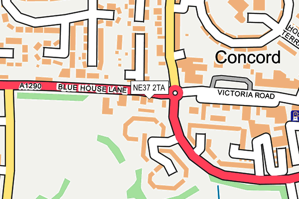
NE37 2TA lies on Blue House Lane in Washington. NE37 2TA is located in the Washington North electoral ward, within the metropolitan district of Sunderland and the English Parliamentary constituency of Washington and Sunderland West. The Sub Integrated Care Board (ICB) Location is NHS North East and North Cumbria ICB - 00P and the police force is Northumbria. This postcode has been in use since January 1980.


GetTheData
Source: OS OpenMap – Local (Ordnance Survey)
Source: OS VectorMap District (Ordnance Survey)
Licence: Open Government Licence (requires attribution)
| Easting | 430483 |
| Northing | 557665 |
| Latitude | 54.912776 |
| Longitude | -1.526054 |
GetTheData
Source: Open Postcode Geo
Licence: Open Government Licence
| Street | Blue House Lane |
| Town/City | Washington |
| Country | England |
| Postcode District | NE37 |
➜ See where NE37 is on a map ➜ Where is Washington? | |
GetTheData
Source: Land Registry Price Paid Data
Licence: Open Government Licence
Elevation or altitude of NE37 2TA as distance above sea level:
| Metres | Feet | |
|---|---|---|
| Elevation | 70m | 230ft |
Elevation is measured from the approximate centre of the postcode, to the nearest point on an OS contour line from OS Terrain 50, which has contour spacing of ten vertical metres.
➜ How high above sea level am I? Find the elevation of your current position using your device's GPS.
GetTheData
Source: Open Postcode Elevation
Licence: Open Government Licence
| Ward | Washington North |
| Constituency | Washington And Sunderland West |
GetTheData
Source: ONS Postcode Database
Licence: Open Government Licence
2017 12 JUN £205,000 |
2009 16 OCT £240,000 |
2002 15 JAN £150,000 |
1998 8 JUL £55,000 |
GetTheData
Source: HM Land Registry Price Paid Data
Licence: Contains HM Land Registry data © Crown copyright and database right 2025. This data is licensed under the Open Government Licence v3.0.
| Victoria Road - Taxi Rank (Victoria Road) | Concord | 202m |
| Blue House Lane-albany Way (Blue House Lane) | Albany | 219m |
| Heworth Road-the Drive (Heworth Road) | Concord | 275m |
| Albany Way - Borrowdale (Albany Way) | Albany | 280m |
| The Drive-heworth Road (The Drive) | Concord | 313m |
| Heworth Station | 4.7km |
GetTheData
Source: NaPTAN
Licence: Open Government Licence
GetTheData
Source: ONS Postcode Database
Licence: Open Government Licence


➜ Get more ratings from the Food Standards Agency
GetTheData
Source: Food Standards Agency
Licence: FSA terms & conditions
| Last Collection | |||
|---|---|---|---|
| Location | Mon-Fri | Sat | Distance |
| Washington Service Station | 16:15 | 12:30 | 256m |
| Victoria Road | 18:45 | 12:45 | 275m |
| Heworth Crescent | 17:15 | 12:30 | 314m |
GetTheData
Source: Dracos
Licence: Creative Commons Attribution-ShareAlike
The below table lists the International Territorial Level (ITL) codes (formerly Nomenclature of Territorial Units for Statistics (NUTS) codes) and Local Administrative Units (LAU) codes for NE37 2TA:
| ITL 1 Code | Name |
|---|---|
| TLC | North East (England) |
| ITL 2 Code | Name |
| TLC2 | Northumberland, and Tyne and Wear |
| ITL 3 Code | Name |
| TLC23 | Sunderland |
| LAU 1 Code | Name |
| E08000024 | Sunderland |
GetTheData
Source: ONS Postcode Directory
Licence: Open Government Licence
The below table lists the Census Output Area (OA), Lower Layer Super Output Area (LSOA), and Middle Layer Super Output Area (MSOA) for NE37 2TA:
| Code | Name | |
|---|---|---|
| OA | E00044973 | |
| LSOA | E01008860 | Sunderland 009F |
| MSOA | E02001799 | Sunderland 009 |
GetTheData
Source: ONS Postcode Directory
Licence: Open Government Licence
| NE37 2TH | Boyne Terrace | 52m |
| NE37 2HX | Baltimore Court | 74m |
| NE37 2TG | Russell Street | 93m |
| NE37 2TQ | Morris Street | 98m |
| NE37 2SY | Victoria Road | 136m |
| NE37 2HU | Baltimore Court | 137m |
| NE37 2EQ | Franklin Court | 141m |
| NE37 2PY | Heworth Road | 142m |
| NE37 2PX | Heworth Road | 154m |
| NE37 2JP | Glendale Avenue | 168m |
GetTheData
Source: Open Postcode Geo; Land Registry Price Paid Data
Licence: Open Government Licence