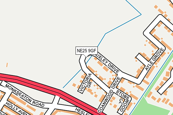
NE25 9GF is located in the St Mary's electoral ward, within the metropolitan district of North Tyneside and the English Parliamentary constituency of Tynemouth. The Sub Integrated Care Board (ICB) Location is NHS North East and North Cumbria ICB - 99C and the police force is Northumbria. This postcode has been in use since May 2015.


GetTheData
Source: OS OpenMap – Local (Ordnance Survey)
Source: OS VectorMap District (Ordnance Survey)
Licence: Open Government Licence (requires attribution)
| Easting | 432721 |
| Northing | 572456 |
| Latitude | 55.045544 |
| Longitude | -1.489464 |
GetTheData
Source: Open Postcode Geo
Licence: Open Government Licence
| Country | England |
| Postcode District | NE25 |
➜ See where NE25 is on a map ➜ Where is Whitley Bay? | |
GetTheData
Source: Land Registry Price Paid Data
Licence: Open Government Licence
Elevation or altitude of NE25 9GF as distance above sea level:
| Metres | Feet | |
|---|---|---|
| Elevation | 40m | 131ft |
Elevation is measured from the approximate centre of the postcode, to the nearest point on an OS contour line from OS Terrain 50, which has contour spacing of ten vertical metres.
➜ How high above sea level am I? Find the elevation of your current position using your device's GPS.
GetTheData
Source: Open Postcode Elevation
Licence: Open Government Licence
| Ward | St Mary's |
| Constituency | Tynemouth |
GetTheData
Source: ONS Postcode Database
Licence: Open Government Licence
2024 28 AUG £460,000 |
2023 9 JAN £485,000 |
15, BROCKWELL GROVE, WHITLEY BAY, NE25 9GF 2020 18 DEC £412,545 |
12, BROCKWELL GROVE, WHITLEY BAY, NE25 9GF 2020 17 DEC £343,995 |
14, BROCKWELL GROVE, WHITLEY BAY, NE25 9GF 2020 11 DEC £429,995 |
11, BROCKWELL GROVE, WHITLEY BAY, NE25 9GF 2020 11 DEC £335,345 |
10, BROCKWELL GROVE, WHITLEY BAY, NE25 9GF 2020 7 DEC £500,645 |
9, BROCKWELL GROVE, WHITLEY BAY, NE25 9GF 2020 27 NOV £429,995 |
16, BROCKWELL GROVE, WHITLEY BAY, NE25 9GF 2020 23 NOV £434,995 |
8, BROCKWELL GROVE, WHITLEY BAY, NE25 9GF 2020 20 NOV £343,995 |
GetTheData
Source: HM Land Registry Price Paid Data
Licence: Contains HM Land Registry data © Crown copyright and database right 2024. This data is licensed under the Open Government Licence v3.0.
| Earsdon Road-seaton House (Earsdon Road) | Earsdon | 224m |
| Earsdon Road-seaton House (Earsdon Road) | Earsdon | 226m |
| Earsdon Road-haddon Close (Earsdon Road) | West Monkseaton | 339m |
| South Wellfield (Hareshaw Road) | West Monkseaton | 365m |
| Earsdon Road | Earsdon | 378m |
| West Monkseaton (Tyne And Wear Metro Station) (Earsdon Road) | West Monkseaton | 963m |
| Shiremoor (Tyne And Wear Metro Station) (Park Lane) | Shiremoor | 1,393m |
GetTheData
Source: NaPTAN
Licence: Open Government Licence
| Percentage of properties with Next Generation Access | 0.0% |
| Percentage of properties with Superfast Broadband | 0.0% |
| Percentage of properties with Ultrafast Broadband | 0.0% |
| Percentage of properties with Full Fibre Broadband | 0.0% |
Superfast Broadband is between 30Mbps and 300Mbps
Ultrafast Broadband is > 300Mbps
| Percentage of properties unable to receive 2Mbps | 0.0% |
| Percentage of properties unable to receive 5Mbps | 0.0% |
| Percentage of properties unable to receive 10Mbps | 0.0% |
| Percentage of properties unable to receive 30Mbps | 0.0% |
GetTheData
Source: Ofcom
Licence: Ofcom Terms of Use (requires attribution)
GetTheData
Source: ONS Postcode Database
Licence: Open Government Licence


➜ Get more ratings from the Food Standards Agency
GetTheData
Source: Food Standards Agency
Licence: FSA terms & conditions
| Last Collection | |||
|---|---|---|---|
| Location | Mon-Fri | Sat | Distance |
| Lesbury Avenue | 16:00 | 11:00 | 1,475m |
| Sherwood | 17:45 | 11:00 | 1,624m |
| Malvern Rod | 16:30 | 12:45 | 1,822m |
GetTheData
Source: Dracos
Licence: Creative Commons Attribution-ShareAlike
The below table lists the International Territorial Level (ITL) codes (formerly Nomenclature of Territorial Units for Statistics (NUTS) codes) and Local Administrative Units (LAU) codes for NE25 9GF:
| ITL 1 Code | Name |
|---|---|
| TLC | North East (England) |
| ITL 2 Code | Name |
| TLC2 | Northumberland, and Tyne and Wear |
| ITL 3 Code | Name |
| TLC22 | Tyneside |
| LAU 1 Code | Name |
| E08000022 | North Tyneside |
GetTheData
Source: ONS Postcode Directory
Licence: Open Government Licence
The below table lists the Census Output Area (OA), Lower Layer Super Output Area (LSOA), and Middle Layer Super Output Area (MSOA) for NE25 9GF:
| Code | Name | |
|---|---|---|
| OA | E00043383 | |
| LSOA | E01008548 | North Tyneside 001B |
| MSOA | E02001738 | North Tyneside 001 |
GetTheData
Source: ONS Postcode Directory
Licence: Open Government Licence
| NE25 9GD | Victoria Grove | 106m |
| NE25 9HB | Hesleyside Road | 152m |
| NE25 9GE | Hauxley Drive | 167m |
| NE25 9HE | Burnside | 171m |
| NE25 9JJ | Monkseaton Road | 189m |
| NE25 9GB | Coanwood Drive | 198m |
| NE25 9HF | Greenhaugh Road | 208m |
| NE25 9JH | Holly Avenue | 222m |
| NE25 9GA | Stobswood Close | 239m |
| NE25 9JG | Wellington Avenue | 241m |
GetTheData
Source: Open Postcode Geo; Land Registry Price Paid Data
Licence: Open Government Licence