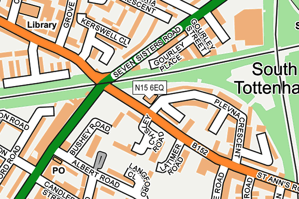
N15 6EQ is located in the Seven Sisters electoral ward, within the London borough of Haringey and the English Parliamentary constituency of Tottenham. The Sub Integrated Care Board (ICB) Location is NHS North Central London ICB - 93C and the police force is Metropolitan Police. This postcode has been in use since January 2011.


GetTheData
Source: OS OpenMap – Local (Ordnance Survey)
Source: OS VectorMap District (Ordnance Survey)
Licence: Open Government Licence (requires attribution)
| Easting | 533178 |
| Northing | 188445 |
| Latitude | 51.579141 |
| Longitude | -0.079400 |
GetTheData
Source: Open Postcode Geo
Licence: Open Government Licence
| Country | England |
| Postcode District | N15 |
➜ See where N15 is on a map | |
GetTheData
Source: Land Registry Price Paid Data
Licence: Open Government Licence
Elevation or altitude of N15 6EQ as distance above sea level:
| Metres | Feet | |
|---|---|---|
| Elevation | 20m | 66ft |
Elevation is measured from the approximate centre of the postcode, to the nearest point on an OS contour line from OS Terrain 50, which has contour spacing of ten vertical metres.
➜ How high above sea level am I? Find the elevation of your current position using your device's GPS.
GetTheData
Source: Open Postcode Elevation
Licence: Open Government Licence
| Ward | Seven Sisters |
| Constituency | Tottenham |
GetTheData
Source: ONS Postcode Database
Licence: Open Government Licence
| Seven Sisters Road Plevna Crescent | South Tottenham | 25m |
| Seven Sisters Road Plevna Crescent | South Tottenham | 28m |
| St Anns Road Seven Sisters Rd (Seven Sisters Road) | South Tottenham | 77m |
| St Anns Road Seven Sisters Rd (Seven Sisters Road) | South Tottenham | 161m |
| Seven Sisters Rd Kerswell Cl (St Anns Road) | South Tottenham | 195m |
| Seven Sisters Underground Station | Seven Sisters | 663m |
| Manor House Underground Station | Manor House | 1,489m |
| Tottenham Hale Underground Station | Tottenham Hale | 1,661m |
| Seven Sisters Station | 0.5km |
| South Tottenham Station | 0.5km |
| Stamford Hill Station | 0.6km |
GetTheData
Source: NaPTAN
Licence: Open Government Licence
GetTheData
Source: ONS Postcode Database
Licence: Open Government Licence


➜ Get more ratings from the Food Standards Agency
GetTheData
Source: Food Standards Agency
Licence: FSA terms & conditions
| Last Collection | |||
|---|---|---|---|
| Location | Mon-Fri | Sat | Distance |
| St Anns Road/Near Bridge | 17:30 | 12:00 | 154m |
| Eastbourne Road/St Anns Road | 17:30 | 12:00 | 197m |
| Russell Road/Culvert Road | 17:30 | 12:00 | 228m |
GetTheData
Source: Dracos
Licence: Creative Commons Attribution-ShareAlike
The below table lists the International Territorial Level (ITL) codes (formerly Nomenclature of Territorial Units for Statistics (NUTS) codes) and Local Administrative Units (LAU) codes for N15 6EQ:
| ITL 1 Code | Name |
|---|---|
| TLI | London |
| ITL 2 Code | Name |
| TLI4 | Inner London - East |
| ITL 3 Code | Name |
| TLI43 | Haringey and Islington |
| LAU 1 Code | Name |
| E09000014 | Haringey |
GetTheData
Source: ONS Postcode Directory
Licence: Open Government Licence
The below table lists the Census Output Area (OA), Lower Layer Super Output Area (LSOA), and Middle Layer Super Output Area (MSOA) for N15 6EQ:
| Code | Name | |
|---|---|---|
| OA | E00010298 | |
| LSOA | E01002053 | Haringey 032A |
| MSOA | E02000428 | Haringey 032 |
GetTheData
Source: ONS Postcode Directory
Licence: Open Government Licence
| N15 6NP | St Anns Road | 50m |
| N15 6DX | Plevna Crescent | 60m |
| N15 6PA | Chisley Road | 108m |
| N15 6PB | Chisley Road | 108m |
| N15 6EH | Chisley Road | 109m |
| N15 6DN | Plevna Crescent | 117m |
| N15 5NE | Seven Sisters Road | 130m |
| N15 5NA | Seven Sisters Road | 131m |
| N15 6JB | Albert Road | 147m |
| N15 5LX | Victoria Crescent | 148m |
GetTheData
Source: Open Postcode Geo; Land Registry Price Paid Data
Licence: Open Government Licence