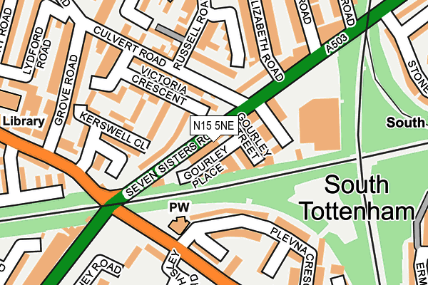
N15 5NE lies on Seven Sisters Road in London. N15 5NE is located in the Seven Sisters electoral ward, within the London borough of Haringey and the English Parliamentary constituency of Tottenham. The Sub Integrated Care Board (ICB) Location is NHS North Central London ICB - 93C and the police force is Metropolitan Police. This postcode has been in use since January 1980.


GetTheData
Source: OS OpenMap – Local (Ordnance Survey)
Source: OS VectorMap District (Ordnance Survey)
Licence: Open Government Licence (requires attribution)
| Easting | 533229 |
| Northing | 188565 |
| Latitude | 51.580210 |
| Longitude | -0.078593 |
GetTheData
Source: Open Postcode Geo
Licence: Open Government Licence
| Street | Seven Sisters Road |
| Town/City | London |
| Country | England |
| Postcode District | N15 |
➜ See where N15 is on a map | |
GetTheData
Source: Land Registry Price Paid Data
Licence: Open Government Licence
Elevation or altitude of N15 5NE as distance above sea level:
| Metres | Feet | |
|---|---|---|
| Elevation | 20m | 66ft |
Elevation is measured from the approximate centre of the postcode, to the nearest point on an OS contour line from OS Terrain 50, which has contour spacing of ten vertical metres.
➜ How high above sea level am I? Find the elevation of your current position using your device's GPS.
GetTheData
Source: Open Postcode Elevation
Licence: Open Government Licence
| Ward | Seven Sisters |
| Constituency | Tottenham |
GetTheData
Source: ONS Postcode Database
Licence: Open Government Licence
| St Anns Road Seven Sisters Rd (Seven Sisters Road) | South Tottenham | 99m |
| Elizabeth Road (Seven Sisters Road) | South Tottenham | 112m |
| Seven Sisters Road Plevna Crescent | South Tottenham | 145m |
| Elizabeth Road | South Tottenham | 149m |
| Seven Sisters Road Plevna Crescent | South Tottenham | 156m |
| Seven Sisters Underground Station | Seven Sisters | 544m |
| Tottenham Hale Underground Station | Tottenham Hale | 1,547m |
| Manor House Underground Station | Manor House | 1,607m |
| Seven Sisters Station | 0.3km |
| South Tottenham Station | 0.5km |
| Stamford Hill Station | 0.7km |
GetTheData
Source: NaPTAN
Licence: Open Government Licence
| Percentage of properties with Next Generation Access | 100.0% |
| Percentage of properties with Superfast Broadband | 100.0% |
| Percentage of properties with Ultrafast Broadband | 60.0% |
| Percentage of properties with Full Fibre Broadband | 0.0% |
Superfast Broadband is between 30Mbps and 300Mbps
Ultrafast Broadband is > 300Mbps
| Percentage of properties unable to receive 2Mbps | 0.0% |
| Percentage of properties unable to receive 5Mbps | 0.0% |
| Percentage of properties unable to receive 10Mbps | 0.0% |
| Percentage of properties unable to receive 30Mbps | 0.0% |
GetTheData
Source: Ofcom
Licence: Ofcom Terms of Use (requires attribution)
GetTheData
Source: ONS Postcode Database
Licence: Open Government Licence


➜ Get more ratings from the Food Standards Agency
GetTheData
Source: Food Standards Agency
Licence: FSA terms & conditions
| Last Collection | |||
|---|---|---|---|
| Location | Mon-Fri | Sat | Distance |
| Russell Road/Culvert Road | 17:30 | 12:00 | 121m |
| St Anns Road/Near Bridge | 17:30 | 12:00 | 194m |
| Eastbourne Road/St Anns Road | 17:30 | 12:00 | 272m |
GetTheData
Source: Dracos
Licence: Creative Commons Attribution-ShareAlike
The below table lists the International Territorial Level (ITL) codes (formerly Nomenclature of Territorial Units for Statistics (NUTS) codes) and Local Administrative Units (LAU) codes for N15 5NE:
| ITL 1 Code | Name |
|---|---|
| TLI | London |
| ITL 2 Code | Name |
| TLI4 | Inner London - East |
| ITL 3 Code | Name |
| TLI43 | Haringey and Islington |
| LAU 1 Code | Name |
| E09000014 | Haringey |
GetTheData
Source: ONS Postcode Directory
Licence: Open Government Licence
The below table lists the Census Output Area (OA), Lower Layer Super Output Area (LSOA), and Middle Layer Super Output Area (MSOA) for N15 5NE:
| Code | Name | |
|---|---|---|
| OA | E00010273 | |
| LSOA | E01002046 | Haringey 026C |
| MSOA | E02000422 | Haringey 026 |
GetTheData
Source: ONS Postcode Directory
Licence: Open Government Licence
| N15 5NA | Seven Sisters Road | 55m |
| N15 5NH | Seven Sisters Road | 69m |
| N15 5LX | Victoria Crescent | 82m |
| N15 5LY | Seven Sisters Road | 96m |
| N15 5LU | Victoria Crescent | 116m |
| N15 6DN | Plevna Crescent | 119m |
| N15 5HP | Culvert Road | 124m |
| N15 6DX | Plevna Crescent | 130m |
| N15 5LT | Russell Road | 136m |
| N15 5HT | Kerswell Close | 155m |
GetTheData
Source: Open Postcode Geo; Land Registry Price Paid Data
Licence: Open Government Licence