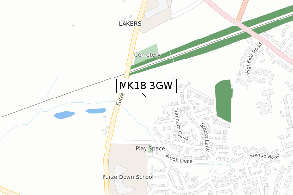
MK18 3GW is located in the Winslow electoral ward, within the unitary authority of Buckinghamshire and the English Parliamentary constituency of Buckingham. The Sub Integrated Care Board (ICB) Location is NHS Buckinghamshire, Oxfordshire and Berkshire West ICB - 14Y and the police force is Thames Valley. This postcode has been in use since May 2019.


GetTheData
Source: OS Open Zoomstack (Ordnance Survey)
Licence: Open Government Licence (requires attribution)
Attribution: Contains OS data © Crown copyright and database right 2024
Source: Open Postcode Geo
Licence: Open Government Licence (requires attribution)
Attribution: Contains OS data © Crown copyright and database right 2024; Contains Royal Mail data © Royal Mail copyright and database right 2024; Source: Office for National Statistics licensed under the Open Government Licence v.3.0
| Easting | 476322 |
| Northing | 228117 |
| Latitude | 51.946333 |
| Longitude | -0.890986 |
GetTheData
Source: Open Postcode Geo
Licence: Open Government Licence
| Country | England |
| Postcode District | MK18 |
➜ See where MK18 is on a map ➜ Where is Winslow? | |
GetTheData
Source: Land Registry Price Paid Data
Licence: Open Government Licence
| Ward | Winslow |
| Constituency | Buckingham |
GetTheData
Source: ONS Postcode Database
Licence: Open Government Licence
2024 12 JUL £410,000 |
4, LACEMAKERS, WINSLOW, BUCKINGHAM, MK18 3GW 2024 29 APR £415,000 |
15, LACEMAKERS, WINSLOW, BUCKINGHAM, MK18 3GW 2021 30 SEP £535,000 |
17, LACEMAKERS, WINSLOW, BUCKINGHAM, MK18 3GW 2021 30 SEP £510,000 |
11, LACEMAKERS, WINSLOW, BUCKINGHAM, MK18 3GW 2021 24 SEP £505,000 |
7, LACEMAKERS, WINSLOW, BUCKINGHAM, MK18 3GW 2021 27 AUG £515,000 |
9, LACEMAKERS, WINSLOW, BUCKINGHAM, MK18 3GW 2021 27 AUG £530,000 |
5, LACEMAKERS, WINSLOW, BUCKINGHAM, MK18 3GW 2021 30 JUL £535,000 |
1, LACEMAKERS, WINSLOW, BUCKINGHAM, MK18 3GW 2021 29 JUL £505,000 |
3, LACEMAKERS, WINSLOW, BUCKINGHAM, MK18 3GW 2021 29 JUL £530,000 |
GetTheData
Source: HM Land Registry Price Paid Data
Licence: Contains HM Land Registry data © Crown copyright and database right 2024. This data is licensed under the Open Government Licence v3.0.
| Redfield Farm (Buckingham Road) | Winslow | 430m |
| Redfield Farm (Buckingham Road) | Winslow | 433m |
| Station Road (Buckingham Road) | Winslow | 482m |
| Station Road (Buckingham Road) | Winslow | 545m |
| Avenue Road (High Street) | Winslow | 638m |
GetTheData
Source: NaPTAN
Licence: Open Government Licence
GetTheData
Source: ONS Postcode Database
Licence: Open Government Licence


➜ Get more ratings from the Food Standards Agency
GetTheData
Source: Food Standards Agency
Licence: FSA terms & conditions
| Last Collection | |||
|---|---|---|---|
| Location | Mon-Fri | Sat | Distance |
| Buckingham Road | 17:00 | 11:45 | 578m |
| Western Lane | 17:45 | 12:00 | 686m |
| Winslow Delivery Office | 17:45 | 12:45 | 721m |
GetTheData
Source: Dracos
Licence: Creative Commons Attribution-ShareAlike
The below table lists the International Territorial Level (ITL) codes (formerly Nomenclature of Territorial Units for Statistics (NUTS) codes) and Local Administrative Units (LAU) codes for MK18 3GW:
| ITL 1 Code | Name |
|---|---|
| TLJ | South East (England) |
| ITL 2 Code | Name |
| TLJ1 | Berkshire, Buckinghamshire and Oxfordshire |
| ITL 3 Code | Name |
| TLJ13 | Buckinghamshire |
| LAU 1 Code | Name |
| E06000060 | Buckinghamshire |
GetTheData
Source: ONS Postcode Directory
Licence: Open Government Licence
The below table lists the Census Output Area (OA), Lower Layer Super Output Area (LSOA), and Middle Layer Super Output Area (MSOA) for MK18 3GW:
| Code | Name | |
|---|---|---|
| OA | E00089493 | |
| LSOA | E01017738 | Aylesbury Vale 005D |
| MSOA | E02003656 | Aylesbury Vale 005 |
GetTheData
Source: ONS Postcode Directory
Licence: Open Government Licence
| MK18 3BW | Furze Lane | 167m |
| MK18 3FZ | Featherbed Close | 221m |
| MK18 3FP | Stocks Lane | 249m |
| MK18 3NB | Furze Lane | 250m |
| MK18 3FY | Browns Close | 259m |
| MK18 3FX | Selby Lane | 318m |
| MK18 3FW | Horsemead Piece | 358m |
| MK18 3FQ | Gorse Croft | 373m |
| MK18 3DU | Highfield Road | 395m |
| MK18 3FT | Rolfe Close | 406m |
GetTheData
Source: Open Postcode Geo; Land Registry Price Paid Data
Licence: Open Government Licence