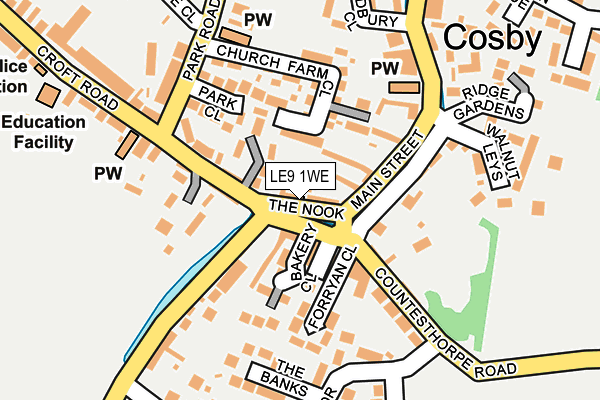
LE9 1WE is located in the Cosby & South Whetstone electoral ward, within the local authority district of Blaby and the English Parliamentary constituency of South Leicestershire. The Sub Integrated Care Board (ICB) Location is NHS Leicester, Leicestershire and Rutland ICB - 03W and the police force is Leicestershire. This postcode has been in use since July 2017.


GetTheData
Source: OS OpenMap – Local (Ordnance Survey)
Source: OS VectorMap District (Ordnance Survey)
Licence: Open Government Licence (requires attribution)
| Easting | 454929 |
| Northing | 294844 |
| Latitude | 52.548700 |
| Longitude | -1.191373 |
GetTheData
Source: Open Postcode Geo
Licence: Open Government Licence
| Country | England |
| Postcode District | LE9 |
➜ See where LE9 is on a map ➜ Where is Cosby? | |
GetTheData
Source: Land Registry Price Paid Data
Licence: Open Government Licence
| Ward | Cosby & South Whetstone |
| Constituency | South Leicestershire |
GetTheData
Source: ONS Postcode Database
Licence: Open Government Licence
2022 17 JUN £470,000 |
7, RIDGE GARDENS, COSBY, LEICESTER, LE9 1WE 2020 4 DEC £515,000 |
9, RIDGE GARDENS, COSBY, LEICESTER, LE9 1WE 2020 26 NOV £504,750 |
11, RIDGE GARDENS, COSBY, LEICESTER, LE9 1WE 2020 10 SEP £495,000 |
2020 21 AUG £410,000 |
17, RIDGE GARDENS, COSBY, LEICESTER, LE9 1WE 2019 18 DEC £570,000 |
1, RIDGE GARDENS, COSBY, LEICESTER, LE9 1WE 2019 1 NOV £740,000 |
19, RIDGE GARDENS, COSBY, LEICESTER, LE9 1WE 2018 3 SEP £450,000 |
3, RIDGE GARDENS, COSBY, LEICESTER, LE9 1WE 2018 1 AUG £394,950 |
5, RIDGE GARDENS, COSBY, LEICESTER, LE9 1WE 2017 9 OCT £399,950 |
GetTheData
Source: HM Land Registry Price Paid Data
Licence: Contains HM Land Registry data © Crown copyright and database right 2025. This data is licensed under the Open Government Licence v3.0.
| Bradbury Close (Main Street) | Cosby | 144m |
| Park Close (Park Road) | Cosby | 338m |
| Park Close (Park Road) | Cosby | 346m |
| The Nook (Croft Road) | Cosby | 356m |
| Victory Park (Park Road) | Cosby | 360m |
| Narborough Station | 2.6km |
| South Wigston Station | 5.4km |
GetTheData
Source: NaPTAN
Licence: Open Government Licence
| Percentage of properties with Next Generation Access | 100.0% |
| Percentage of properties with Superfast Broadband | 100.0% |
| Percentage of properties with Ultrafast Broadband | 0.0% |
| Percentage of properties with Full Fibre Broadband | 0.0% |
Superfast Broadband is between 30Mbps and 300Mbps
Ultrafast Broadband is > 300Mbps
| Percentage of properties unable to receive 2Mbps | 0.0% |
| Percentage of properties unable to receive 5Mbps | 0.0% |
| Percentage of properties unable to receive 10Mbps | 0.0% |
| Percentage of properties unable to receive 30Mbps | 0.0% |
GetTheData
Source: Ofcom
Licence: Ofcom Terms of Use (requires attribution)
GetTheData
Source: ONS Postcode Database
Licence: Open Government Licence


➜ Get more ratings from the Food Standards Agency
GetTheData
Source: Food Standards Agency
Licence: FSA terms & conditions
| Last Collection | |||
|---|---|---|---|
| Location | Mon-Fri | Sat | Distance |
| Springwell Lane | 17:00 | 09:00 | 1,402m |
| Cambridge Road | 17:00 | 09:00 | 1,531m |
| Ashtree Road | 17:00 | 08:45 | 2,024m |
GetTheData
Source: Dracos
Licence: Creative Commons Attribution-ShareAlike
The below table lists the International Territorial Level (ITL) codes (formerly Nomenclature of Territorial Units for Statistics (NUTS) codes) and Local Administrative Units (LAU) codes for LE9 1WE:
| ITL 1 Code | Name |
|---|---|
| TLF | East Midlands (England) |
| ITL 2 Code | Name |
| TLF2 | Leicestershire, Rutland and Northamptonshire |
| ITL 3 Code | Name |
| TLF22 | Leicestershire CC and Rutland |
| LAU 1 Code | Name |
| E07000129 | Blaby |
GetTheData
Source: ONS Postcode Directory
Licence: Open Government Licence
The below table lists the Census Output Area (OA), Lower Layer Super Output Area (LSOA), and Middle Layer Super Output Area (MSOA) for LE9 1WE:
| Code | Name | |
|---|---|---|
| OA | E00129982 | |
| LSOA | E01025615 | Blaby 009A |
| MSOA | E02005341 | Blaby 009 |
GetTheData
Source: ONS Postcode Directory
Licence: Open Government Licence
| LE9 1UH | Cambrian Close | 60m |
| LE9 1TY | Walnut Leys | 65m |
| LE9 1UB | Arnold Close | 82m |
| LE9 1UU | Main Street | 142m |
| LE9 1UW | Main Street | 151m |
| LE9 1UE | Cotswold Avenue | 183m |
| LE9 1UG | Chiltern Avenue | 192m |
| LE9 1US | Hill View Drive | 195m |
| LE9 1RW | Church Farm Close | 224m |
| LE9 1UX | Malvern Crescent | 230m |
GetTheData
Source: Open Postcode Geo; Land Registry Price Paid Data
Licence: Open Government Licence