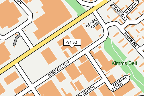
IP24 3QT is located in the Thetford Burrell electoral ward, within the local authority district of Breckland and the English Parliamentary constituency of South West Norfolk. The Sub Integrated Care Board (ICB) Location is NHS Norfolk and Waveney ICB - 26A and the police force is Norfolk. This postcode has been in use since January 1980.


GetTheData
Source: OS OpenMap – Local (Ordnance Survey)
Source: OS VectorMap District (Ordnance Survey)
Licence: Open Government Licence (requires attribution)
| Easting | 585907 |
| Northing | 282254 |
| Latitude | 52.406702 |
| Longitude | 0.731612 |
GetTheData
Source: Open Postcode Geo
Licence: Open Government Licence
| Country | England |
| Postcode District | IP24 |
➜ See where IP24 is on a map ➜ Where is Thetford? | |
GetTheData
Source: Land Registry Price Paid Data
Licence: Open Government Licence
Elevation or altitude of IP24 3QT as distance above sea level:
| Metres | Feet | |
|---|---|---|
| Elevation | 30m | 98ft |
Elevation is measured from the approximate centre of the postcode, to the nearest point on an OS contour line from OS Terrain 50, which has contour spacing of ten vertical metres.
➜ How high above sea level am I? Find the elevation of your current position using your device's GPS.
GetTheData
Source: Open Postcode Elevation
Licence: Open Government Licence
| Ward | Thetford Burrell |
| Constituency | South West Norfolk |
GetTheData
Source: ONS Postcode Database
Licence: Open Government Licence
| Footbridge (St Martins Way) | Thetford | 265m |
| Mingay Road (Kimms Belt) | Thetford | 270m |
| Mingay Road (Kimms Belt) | Thetford | 273m |
| Footbridge (St Martins Way) | Thetford | 291m |
| St Johns Way (St Martins Way) | Thetford | 296m |
| Thetford Station | 1.7km |
GetTheData
Source: NaPTAN
Licence: Open Government Licence
GetTheData
Source: ONS Postcode Database
Licence: Open Government Licence


➜ Get more ratings from the Food Standards Agency
GetTheData
Source: Food Standards Agency
Licence: FSA terms & conditions
| Last Collection | |||
|---|---|---|---|
| Location | Mon-Fri | Sat | Distance |
| Kimms Belt | 17:15 | 12:00 | 160m |
| Post Office, 15 Pine Close | 17:15 | 12:00 | 443m |
| 103 Canons Walk | 17:00 | 12:00 | 577m |
GetTheData
Source: Dracos
Licence: Creative Commons Attribution-ShareAlike
The below table lists the International Territorial Level (ITL) codes (formerly Nomenclature of Territorial Units for Statistics (NUTS) codes) and Local Administrative Units (LAU) codes for IP24 3QT:
| ITL 1 Code | Name |
|---|---|
| TLH | East |
| ITL 2 Code | Name |
| TLH1 | East Anglia |
| ITL 3 Code | Name |
| TLH17 | Breckland and South Norfolk |
| LAU 1 Code | Name |
| E07000143 | Breckland |
GetTheData
Source: ONS Postcode Directory
Licence: Open Government Licence
The below table lists the Census Output Area (OA), Lower Layer Super Output Area (LSOA), and Middle Layer Super Output Area (MSOA) for IP24 3QT:
| Code | Name | |
|---|---|---|
| OA | E00134555 | |
| LSOA | E01026477 | Breckland 017D |
| MSOA | E02005519 | Breckland 017 |
GetTheData
Source: ONS Postcode Directory
Licence: Open Government Licence
| IP24 3QE | St Martins Way | 211m |
| IP24 3JQ | Kimms Belt | 215m |
| IP24 3JG | Kimms Belt | 221m |
| IP24 3JF | Stearne Close | 258m |
| IP24 3RG | Faraday Place | 268m |
| IP24 3JJ | Mingay Road | 280m |
| IP24 3QF | St Martins Way | 289m |
| IP24 3QD | St Martins Way | 289m |
| IP24 3RY | Caxton Way | 301m |
| IP24 3RA | Burrell Way | 304m |
GetTheData
Source: Open Postcode Geo; Land Registry Price Paid Data
Licence: Open Government Licence