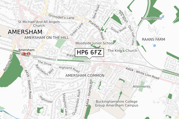
HP6 6FZ is located in the Amersham and Chesham Bois electoral ward, within the unitary authority of Buckinghamshire and the English Parliamentary constituency of Chesham and Amersham. The Sub Integrated Care Board (ICB) Location is NHS Buckinghamshire, Oxfordshire and Berkshire West ICB - 14Y and the police force is Thames Valley. This postcode has been in use since April 2020.


GetTheData
Source: OS Open Zoomstack (Ordnance Survey)
Licence: Open Government Licence (requires attribution)
Attribution: Contains OS data © Crown copyright and database right 2025
Source: Open Postcode Geo
Licence: Open Government Licence (requires attribution)
Attribution: Contains OS data © Crown copyright and database right 2025; Contains Royal Mail data © Royal Mail copyright and database right 2025; Source: Office for National Statistics licensed under the Open Government Licence v.3.0
| Easting | 497277 |
| Northing | 198108 |
| Latitude | 51.673334 |
| Longitude | -0.594614 |
GetTheData
Source: Open Postcode Geo
Licence: Open Government Licence
| Country | England |
| Postcode District | HP6 |
➜ See where HP6 is on a map ➜ Where is Amersham? | |
GetTheData
Source: Land Registry Price Paid Data
Licence: Open Government Licence
| Ward | Amersham And Chesham Bois |
| Constituency | Chesham And Amersham |
GetTheData
Source: ONS Postcode Database
Licence: Open Government Licence
2020 21 MAY £560,000 |
2020 4 MAR £357,212 |
GetTheData
Source: HM Land Registry Price Paid Data
Licence: Contains HM Land Registry data © Crown copyright and database right 2025. This data is licensed under the Open Government Licence v3.0.
| Plantation Road (Woodside Road) | Amersham | 73m |
| Plantation Road (Woodside Road) | Amersham | 113m |
| Blackhorse Bridge (White Lion Road) | Amersham | 174m |
| Blackhorse Close (Plantation Road) | Amersham | 235m |
| Blackhorse Bridge (White Lion Road) | Amersham | 249m |
| Amersham Underground Station | Amersham | 909m |
| Amersham Station | 0.9km |
| Chalfont & Latimer Station | 2.4km |
GetTheData
Source: NaPTAN
Licence: Open Government Licence
GetTheData
Source: ONS Postcode Database
Licence: Open Government Licence


➜ Get more ratings from the Food Standards Agency
GetTheData
Source: Food Standards Agency
Licence: FSA terms & conditions
| Last Collection | |||
|---|---|---|---|
| Location | Mon-Fri | Sat | Distance |
| Blackhorse Bridge | 17:30 | 11:45 | 180m |
| Stanley Hill | 17:15 | 11:30 | 204m |
| Woodside Road | 17:15 | 11:45 | 430m |
GetTheData
Source: Dracos
Licence: Creative Commons Attribution-ShareAlike
The below table lists the International Territorial Level (ITL) codes (formerly Nomenclature of Territorial Units for Statistics (NUTS) codes) and Local Administrative Units (LAU) codes for HP6 6FZ:
| ITL 1 Code | Name |
|---|---|
| TLJ | South East (England) |
| ITL 2 Code | Name |
| TLJ1 | Berkshire, Buckinghamshire and Oxfordshire |
| ITL 3 Code | Name |
| TLJ13 | Buckinghamshire |
| LAU 1 Code | Name |
| E06000060 | Buckinghamshire |
GetTheData
Source: ONS Postcode Directory
Licence: Open Government Licence
The below table lists the Census Output Area (OA), Lower Layer Super Output Area (LSOA), and Middle Layer Super Output Area (MSOA) for HP6 6FZ:
| Code | Name | |
|---|---|---|
| OA | E00089515 | |
| LSOA | E01017741 | Chiltern 006A |
| MSOA | E02003681 | Chiltern 006 |
GetTheData
Source: ONS Postcode Directory
Licence: Open Government Licence
| HP7 9FD | Meadow Bank Close | 78m |
| HP6 6NU | Woodside Road | 93m |
| HP6 6NR | Woodside Road | 97m |
| HP7 9AS | Nursery Close | 117m |
| HP6 6NP | Woodside Road | 121m |
| HP6 6NT | Woodside Road | 126m |
| HP7 9EU | Stanley Hill | 135m |
| HP6 6NS | Duncombe Close | 148m |
| HP7 9AR | The Meadows | 153m |
| HP7 9AT | The Meadows | 167m |
GetTheData
Source: Open Postcode Geo; Land Registry Price Paid Data
Licence: Open Government Licence