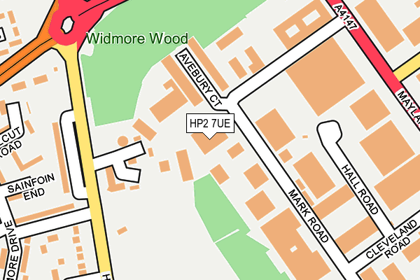
HP2 7UE is located in the Adeyfield East electoral ward, within the local authority district of Dacorum and the English Parliamentary constituency of Hemel Hempstead. The Sub Integrated Care Board (ICB) Location is NHS Hertfordshire and West Essex ICB - 06N and the police force is Hertfordshire. This postcode has been in use since December 2001.


GetTheData
Source: OS OpenMap – Local (Ordnance Survey)
Source: OS VectorMap District (Ordnance Survey)
Licence: Open Government Licence (requires attribution)
| Easting | 507394 |
| Northing | 208394 |
| Latitude | 51.763938 |
| Longitude | -0.445218 |
GetTheData
Source: Open Postcode Geo
Licence: Open Government Licence
| Country | England |
| Postcode District | HP2 |
➜ See where HP2 is on a map ➜ Where is Hemel Hempstead? | |
GetTheData
Source: Land Registry Price Paid Data
Licence: Open Government Licence
Elevation or altitude of HP2 7UE as distance above sea level:
| Metres | Feet | |
|---|---|---|
| Elevation | 140m | 459ft |
Elevation is measured from the approximate centre of the postcode, to the nearest point on an OS contour line from OS Terrain 50, which has contour spacing of ten vertical metres.
➜ How high above sea level am I? Find the elevation of your current position using your device's GPS.
GetTheData
Source: Open Postcode Elevation
Licence: Open Government Licence
| Ward | Adeyfield East |
| Constituency | Hemel Hempstead |
GetTheData
Source: ONS Postcode Database
Licence: Open Government Licence
| Farmhouse Lane (High Street Green) | Highfield | 180m |
| Farmhouse Lane (High Street Green) | Highfield | 186m |
| Atlas Copco (Swallowdale Lane) | Maylands Business Park | 259m |
| Atlas Copco (Swallowdale Lane) | Maylands Business Park | 261m |
| Mark Road (Maylands Avenue) | Maylands Business Park | 269m |
| Apsley Station | 3.7km |
| Hemel Hempstead Station | 4km |
GetTheData
Source: NaPTAN
Licence: Open Government Licence
GetTheData
Source: ONS Postcode Database
Licence: Open Government Licence


➜ Get more ratings from the Food Standards Agency
GetTheData
Source: Food Standards Agency
Licence: FSA terms & conditions
| Last Collection | |||
|---|---|---|---|
| Location | Mon-Fri | Sat | Distance |
| Cleveland Road | 17:30 | 12:00 | 282m |
| Widmore Drive | 17:30 | 12:00 | 322m |
| Cleveland Road | 18:30 | 456m | |
GetTheData
Source: Dracos
Licence: Creative Commons Attribution-ShareAlike
The below table lists the International Territorial Level (ITL) codes (formerly Nomenclature of Territorial Units for Statistics (NUTS) codes) and Local Administrative Units (LAU) codes for HP2 7UE:
| ITL 1 Code | Name |
|---|---|
| TLH | East |
| ITL 2 Code | Name |
| TLH2 | Bedfordshire and Hertfordshire |
| ITL 3 Code | Name |
| TLH23 | Hertfordshire CC |
| LAU 1 Code | Name |
| E07000096 | Dacorum |
GetTheData
Source: ONS Postcode Directory
Licence: Open Government Licence
The below table lists the Census Output Area (OA), Lower Layer Super Output Area (LSOA), and Middle Layer Super Output Area (MSOA) for HP2 7UE:
| Code | Name | |
|---|---|---|
| OA | E00118609 | |
| LSOA | E01023346 | Dacorum 013B |
| MSOA | E02004868 | Dacorum 013 |
GetTheData
Source: ONS Postcode Directory
Licence: Open Government Licence
| HP2 7TA | Avebury Court | 112m |
| HP2 7DN | Mark Road | 117m |
| HP2 7AR | Farmhouse Lane | 151m |
| HP2 7DF | Maylands Avenue | 215m |
| HP2 7AA | High Street Green | 221m |
| HP2 5NG | Dellcut Road | 267m |
| HP2 5NF | Dellcut Road | 283m |
| HP2 7AB | Connaught Close | 285m |
| HP2 5NH | Deimos Drive | 313m |
| HP2 7BW | Mark Road | 327m |
GetTheData
Source: Open Postcode Geo; Land Registry Price Paid Data
Licence: Open Government Licence