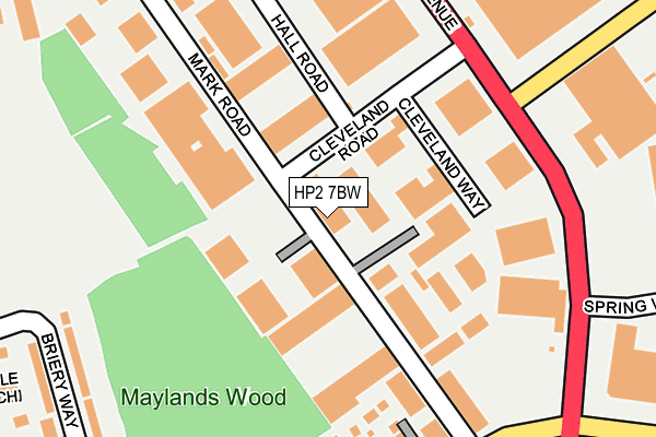
HP2 7BW lies on Mark Road in Hemel Hempstead Industrial Estate, Hemel Hempstead. HP2 7BW is located in the Adeyfield East electoral ward, within the local authority district of Dacorum and the English Parliamentary constituency of Hemel Hempstead. The Sub Integrated Care Board (ICB) Location is NHS Hertfordshire and West Essex ICB - 06N and the police force is Hertfordshire. This postcode has been in use since January 1980.


GetTheData
Source: OS OpenMap – Local (Ordnance Survey)
Source: OS VectorMap District (Ordnance Survey)
Licence: Open Government Licence (requires attribution)
| Easting | 507634 |
| Northing | 208172 |
| Latitude | 51.761904 |
| Longitude | -0.441787 |
GetTheData
Source: Open Postcode Geo
Licence: Open Government Licence
| Street | Mark Road |
| Locality | Hemel Hempstead Industrial Estate |
| Town/City | Hemel Hempstead |
| Country | England |
| Postcode District | HP2 |
➜ See where HP2 is on a map ➜ Where is Hemel Hempstead? | |
GetTheData
Source: Land Registry Price Paid Data
Licence: Open Government Licence
Elevation or altitude of HP2 7BW as distance above sea level:
| Metres | Feet | |
|---|---|---|
| Elevation | 140m | 459ft |
Elevation is measured from the approximate centre of the postcode, to the nearest point on an OS contour line from OS Terrain 50, which has contour spacing of ten vertical metres.
➜ How high above sea level am I? Find the elevation of your current position using your device's GPS.
GetTheData
Source: Open Postcode Elevation
Licence: Open Government Licence
| Ward | Adeyfield East |
| Constituency | Hemel Hempstead |
GetTheData
Source: ONS Postcode Database
Licence: Open Government Licence
| Cleveland Road (Maylands Avenue) | Maylands Business Park | 211m |
| Maylands Avenue (Wood Lane End) | Maylands Business Park | 263m |
| Wood Lane End North (Maylands Avenue) | Maylands Business Park | 268m |
| Wood Lane End South (Maylands Avenue) | Maylands Business Park | 318m |
| Wood Lane End South (Maylands Avenue) | Maylands Business Park | 327m |
| Apsley Station | 3.6km |
| Hemel Hempstead Station | 4km |
GetTheData
Source: NaPTAN
Licence: Open Government Licence
Estimated total energy consumption in HP2 7BW by fuel type, 2015.
| Consumption (kWh) | 136,718 |
|---|---|
| Meter count | 6 |
| Mean (kWh/meter) | 22,786 |
| Median (kWh/meter) | 22,474 |
GetTheData
Source: Postcode level gas estimates: 2015 (experimental)
Source: Postcode level electricity estimates: 2015 (experimental)
Licence: Open Government Licence
GetTheData
Source: ONS Postcode Database
Licence: Open Government Licence


➜ Get more ratings from the Food Standards Agency
GetTheData
Source: Food Standards Agency
Licence: FSA terms & conditions
| Last Collection | |||
|---|---|---|---|
| Location | Mon-Fri | Sat | Distance |
| Cleveland Road | 17:30 | 12:00 | 48m |
| Cleveland Road | 18:30 | 253m | |
| Mail Centre Boxes | 18:30 | 15:00 | 257m |
GetTheData
Source: Dracos
Licence: Creative Commons Attribution-ShareAlike
The below table lists the International Territorial Level (ITL) codes (formerly Nomenclature of Territorial Units for Statistics (NUTS) codes) and Local Administrative Units (LAU) codes for HP2 7BW:
| ITL 1 Code | Name |
|---|---|
| TLH | East |
| ITL 2 Code | Name |
| TLH2 | Bedfordshire and Hertfordshire |
| ITL 3 Code | Name |
| TLH23 | Hertfordshire CC |
| LAU 1 Code | Name |
| E07000096 | Dacorum |
GetTheData
Source: ONS Postcode Directory
Licence: Open Government Licence
The below table lists the Census Output Area (OA), Lower Layer Super Output Area (LSOA), and Middle Layer Super Output Area (MSOA) for HP2 7BW:
| Code | Name | |
|---|---|---|
| OA | E00118612 | |
| LSOA | E01023346 | Dacorum 013B |
| MSOA | E02004868 | Dacorum 013 |
GetTheData
Source: ONS Postcode Directory
Licence: Open Government Licence
| HP2 7DA | Sovereign Park | 129m |
| HP2 7BN | Mark Road | 161m |
| HP2 7DE | Maylands Avenue | 172m |
| HP2 4RE | Kiln Cottages | 200m |
| HP2 7DN | Mark Road | 213m |
| HP2 4RJ | Whitmores Wood | 248m |
| HP2 4RA | Wood Lane End | 278m |
| HP2 7AN | Briery Way | 310m |
| HP2 4QY | 327m | |
| HP2 7DF | Maylands Avenue | 339m |
GetTheData
Source: Open Postcode Geo; Land Registry Price Paid Data
Licence: Open Government Licence