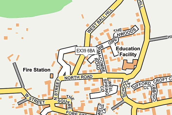
EX39 6BA lies on Turners Crescent in Hartland, Bideford. EX39 6BA is located in the Hartland electoral ward, within the local authority district of Torridge and the English Parliamentary constituency of Torridge and West Devon. The Sub Integrated Care Board (ICB) Location is NHS Devon ICB - 15N and the police force is Devon & Cornwall. This postcode has been in use since January 1980.


GetTheData
Source: OS OpenMap – Local (Ordnance Survey)
Source: OS VectorMap District (Ordnance Survey)
Licence: Open Government Licence (requires attribution)
| Easting | 225958 |
| Northing | 124585 |
| Latitude | 50.994275 |
| Longitude | -4.481462 |
GetTheData
Source: Open Postcode Geo
Licence: Open Government Licence
| Street | Turners Crescent |
| Locality | Hartland |
| Town/City | Bideford |
| Country | England |
| Postcode District | EX39 |
➜ See where EX39 is on a map ➜ Where is Hartland? | |
GetTheData
Source: Land Registry Price Paid Data
Licence: Open Government Licence
Elevation or altitude of EX39 6BA as distance above sea level:
| Metres | Feet | |
|---|---|---|
| Elevation | 110m | 361ft |
Elevation is measured from the approximate centre of the postcode, to the nearest point on an OS contour line from OS Terrain 50, which has contour spacing of ten vertical metres.
➜ How high above sea level am I? Find the elevation of your current position using your device's GPS.
GetTheData
Source: Open Postcode Elevation
Licence: Open Government Licence
| Ward | Hartland |
| Constituency | Torridge And West Devon |
GetTheData
Source: ONS Postcode Database
Licence: Open Government Licence
6, TURNERS CRESCENT, HARTLAND, BIDEFORD, EX39 6BA 2023 11 SEP £235,000 |
2017 22 NOV £205,000 |
2010 5 OCT £186,500 |
2009 21 DEC £152,000 |
1, TURNERS CRESCENT, HARTLAND, BIDEFORD, EX39 6BA 2005 16 FEB £165,000 |
1, TURNERS CRESCENT, HARTLAND, BIDEFORD, EX39 6BA 2002 14 NOV £105,000 |
GetTheData
Source: HM Land Registry Price Paid Data
Licence: Contains HM Land Registry data © Crown copyright and database right 2025. This data is licensed under the Open Government Licence v3.0.
| Northgate Green (North Road) | Hartland | 101m |
| Primary School (North Road) | Hartland | 135m |
| Primary School (North Road) | Hartland | 142m |
| Methodist Church (Fore Street) | Hartland | 408m |
| Methodist Church (Fore Street) | Hartland | 418m |
GetTheData
Source: NaPTAN
Licence: Open Government Licence
| Percentage of properties with Next Generation Access | 100.0% |
| Percentage of properties with Superfast Broadband | 100.0% |
| Percentage of properties with Ultrafast Broadband | 0.0% |
| Percentage of properties with Full Fibre Broadband | 0.0% |
Superfast Broadband is between 30Mbps and 300Mbps
Ultrafast Broadband is > 300Mbps
| Percentage of properties unable to receive 2Mbps | 0.0% |
| Percentage of properties unable to receive 5Mbps | 0.0% |
| Percentage of properties unable to receive 10Mbps | 0.0% |
| Percentage of properties unable to receive 30Mbps | 0.0% |
GetTheData
Source: Ofcom
Licence: Ofcom Terms of Use (requires attribution)
GetTheData
Source: ONS Postcode Database
Licence: Open Government Licence


➜ Get more ratings from the Food Standards Agency
GetTheData
Source: Food Standards Agency
Licence: FSA terms & conditions
| Last Collection | |||
|---|---|---|---|
| Location | Mon-Fri | Sat | Distance |
| Edistone | 14:55 | 12:00 | 2,604m |
| Darracott Post Office | 15:15 | 10:45 | 4,955m |
GetTheData
Source: Dracos
Licence: Creative Commons Attribution-ShareAlike
The below table lists the International Territorial Level (ITL) codes (formerly Nomenclature of Territorial Units for Statistics (NUTS) codes) and Local Administrative Units (LAU) codes for EX39 6BA:
| ITL 1 Code | Name |
|---|---|
| TLK | South West (England) |
| ITL 2 Code | Name |
| TLK4 | Devon |
| ITL 3 Code | Name |
| TLK43 | Devon CC |
| LAU 1 Code | Name |
| E07000046 | Torridge |
GetTheData
Source: ONS Postcode Directory
Licence: Open Government Licence
The below table lists the Census Output Area (OA), Lower Layer Super Output Area (LSOA), and Middle Layer Super Output Area (MSOA) for EX39 6BA:
| Code | Name | |
|---|---|---|
| OA | E00102790 | |
| LSOA | E01020292 | Torridge 005B |
| MSOA | E02004224 | Torridge 005 |
GetTheData
Source: ONS Postcode Directory
Licence: Open Government Licence
| EX39 6BP | North Road | 52m |
| EX39 6BW | Northgate | 60m |
| EX39 6BB | Brimacombe Road | 65m |
| EX39 6JB | Meadow View | 117m |
| EX39 6DE | North Street | 152m |
| EX39 6JA | The Greenwoods | 153m |
| EX39 6BR | Pines Close | 163m |
| EX39 6BX | West Ball Hill | 173m |
| EX39 6BL | The Square | 188m |
| EX39 6EU | Well Lane | 188m |
GetTheData
Source: Open Postcode Geo; Land Registry Price Paid Data
Licence: Open Government Licence