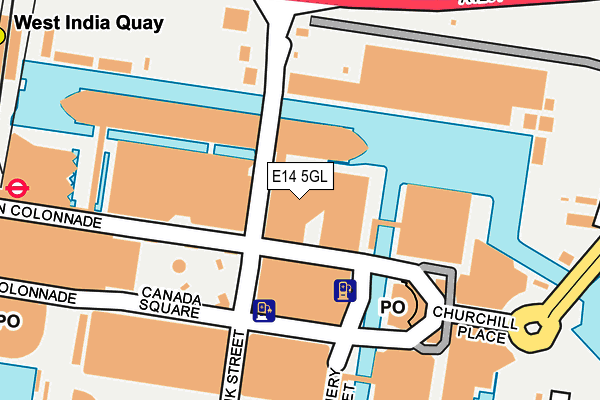
E14 5GL is located in the Canary Wharf electoral ward, within the London borough of Tower Hamlets and the English Parliamentary constituency of Poplar and Limehouse. The Sub Integrated Care Board (ICB) Location is NHS North East London ICB - A3A8R and the police force is Metropolitan Police. This postcode has been in use since May 2009.


GetTheData
Source: OS OpenMap – Local (Ordnance Survey)
Source: OS VectorMap District (Ordnance Survey)
Licence: Open Government Licence (requires attribution)
| Easting | 537774 |
| Northing | 180361 |
| Latitude | 51.505395 |
| Longitude | -0.016276 |
GetTheData
Source: Open Postcode Geo
Licence: Open Government Licence
| Country | England |
| Postcode District | E14 |
➜ See where E14 is on a map ➜ Where is London? | |
GetTheData
Source: Land Registry Price Paid Data
Licence: Open Government Licence
Elevation or altitude of E14 5GL as distance above sea level:
| Metres | Feet | |
|---|---|---|
| Elevation | 10m | 33ft |
Elevation is measured from the approximate centre of the postcode, to the nearest point on an OS contour line from OS Terrain 50, which has contour spacing of ten vertical metres.
➜ How high above sea level am I? Find the elevation of your current position using your device's GPS.
GetTheData
Source: Open Postcode Elevation
Licence: Open Government Licence
| Ward | Canary Wharf |
| Constituency | Poplar And Limehouse |
GetTheData
Source: ONS Postcode Database
Licence: Open Government Licence
| Canada Square North | Canary Wharf | 95m |
| Canada Square South | Canary Wharf | 145m |
| Churchill Place | Canary Wharf | 184m |
| Churchill Place | Canary Wharf | 194m |
| Canary Wharf | Canary Wharf | 302m |
| Canary Wharf Underground Station | Canary Wharf | 253m |
| Poplar Dlr Station (Castor Lane) | Poplar | 272m |
| Canary Wharf Dlr Station (South Colonnade) | Canary Wharf | 334m |
| West India Quay Dlr Station (West India Quay) | West India Quay | 334m |
| Heron Quays Dlr Station (Heron Quay) | Heron Quays | 422m |
| Limehouse Station | 1.8km |
| Canada Water Station | 2.5km |
| Rotherhithe Station | 2.5km |
GetTheData
Source: NaPTAN
Licence: Open Government Licence
GetTheData
Source: ONS Postcode Database
Licence: Open Government Licence


➜ Get more ratings from the Food Standards Agency
GetTheData
Source: Food Standards Agency
Licence: FSA terms & conditions
| Last Collection | |||
|---|---|---|---|
| Location | Mon-Fri | Sat | Distance |
| Waitrose | 19:00 | 11:30 | 92m |
| O/S Waitrose | 19:00 | 11:30 | 92m |
| Churchill Place Pocl | 17:30 | 12:00 | 128m |
GetTheData
Source: Dracos
Licence: Creative Commons Attribution-ShareAlike
| Risk of E14 5GL flooding from rivers and sea | Very Low |
| ➜ E14 5GL flood map | |
GetTheData
Source: Open Flood Risk by Postcode
Licence: Open Government Licence
The below table lists the International Territorial Level (ITL) codes (formerly Nomenclature of Territorial Units for Statistics (NUTS) codes) and Local Administrative Units (LAU) codes for E14 5GL:
| ITL 1 Code | Name |
|---|---|
| TLI | London |
| ITL 2 Code | Name |
| TLI4 | Inner London - East |
| ITL 3 Code | Name |
| TLI42 | Tower Hamlets |
| LAU 1 Code | Name |
| E09000030 | Tower Hamlets |
GetTheData
Source: ONS Postcode Directory
Licence: Open Government Licence
The below table lists the Census Output Area (OA), Lower Layer Super Output Area (LSOA), and Middle Layer Super Output Area (MSOA) for E14 5GL:
| Code | Name | |
|---|---|---|
| OA | E00167158 | |
| LSOA | E01004277 | Tower Hamlets 033A |
| MSOA | E02006854 | Tower Hamlets 033 |
GetTheData
Source: ONS Postcode Directory
Licence: Open Government Licence
| E14 5ST | Billingsgate Market | 227m |
| E14 5AB | Canada Square | 231m |
| E14 5NY | Bank Street | 305m |
| E14 9JX | Harbour Exchange Square | 360m |
| E14 5SF | Boardwalk Place | 361m |
| E14 0AP | Poplar High Street | 366m |
| E14 0BY | Stoneyard Lane | 371m |
| E14 4EG | Hertsmere Road | 379m |
| E14 0AW | Poplar High Street | 386m |
| E14 0AR | Poplar High Street | 386m |
GetTheData
Source: Open Postcode Geo; Land Registry Price Paid Data
Licence: Open Government Licence