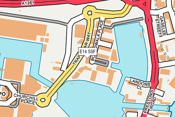
E14 5SF lies on Boardwalk Place in London. E14 5SF is located in the Blackwall & Cubitt Town electoral ward, within the London borough of Tower Hamlets and the English Parliamentary constituency of Poplar and Limehouse. The Sub Integrated Care Board (ICB) Location is NHS North East London ICB - A3A8R and the police force is Metropolitan Police. This postcode has been in use since December 2001.


GetTheData
Source: OS OpenMap – Local (Ordnance Survey)
Source: OS VectorMap District (Ordnance Survey)
Licence: Open Government Licence (requires attribution)
| Easting | 538134 |
| Northing | 180335 |
| Latitude | 51.505074 |
| Longitude | -0.011075 |
GetTheData
Source: Open Postcode Geo
Licence: Open Government Licence
| Street | Boardwalk Place |
| Town/City | London |
| Country | England |
| Postcode District | E14 |
➜ See where E14 is on a map ➜ Where is London? | |
GetTheData
Source: Land Registry Price Paid Data
Licence: Open Government Licence
Elevation or altitude of E14 5SF as distance above sea level:
| Metres | Feet | |
|---|---|---|
| Elevation | 10m | 33ft |
Elevation is measured from the approximate centre of the postcode, to the nearest point on an OS contour line from OS Terrain 50, which has contour spacing of ten vertical metres.
➜ How high above sea level am I? Find the elevation of your current position using your device's GPS.
GetTheData
Source: Open Postcode Elevation
Licence: Open Government Licence
| Ward | Blackwall & Cubitt Town |
| Constituency | Poplar And Limehouse |
GetTheData
Source: ONS Postcode Database
Licence: Open Government Licence
| Trafalgar Way | Blackwall | 67m |
| Billingsgate Market (Trafalgar Way) | Blackwall | 133m |
| Billingsgate Market (Trafalgar Way) | Blackwall | 140m |
| Churchill Place | Canary Wharf | 214m |
| Churchill Place | Canary Wharf | 263m |
| Blackwall Dlr Station (Preston's Road) | Blackwall | 433m |
| Canary Wharf Underground Station | Canary Wharf | 526m |
| Poplar Dlr Station (Castor Lane) | Poplar | 528m |
| South Quay Dlr Station (Marsh Wall) | South Quay | 659m |
| All Saints Dlr Station (East India Dock Road) | All Saints | 674m |
| Limehouse Station | 2.2km |
| Maze Hill Station | 2.7km |
| Canada Water Station | 2.8km |
GetTheData
Source: NaPTAN
Licence: Open Government Licence
| Percentage of properties with Next Generation Access | 100.0% |
| Percentage of properties with Superfast Broadband | 100.0% |
| Percentage of properties with Ultrafast Broadband | 0.0% |
| Percentage of properties with Full Fibre Broadband | 0.0% |
Superfast Broadband is between 30Mbps and 300Mbps
Ultrafast Broadband is > 300Mbps
| Percentage of properties unable to receive 2Mbps | 0.0% |
| Percentage of properties unable to receive 5Mbps | 0.0% |
| Percentage of properties unable to receive 10Mbps | 0.0% |
| Percentage of properties unable to receive 30Mbps | 0.0% |
GetTheData
Source: Ofcom
Licence: Ofcom Terms of Use (requires attribution)
GetTheData
Source: ONS Postcode Database
Licence: Open Government Licence


➜ Get more ratings from the Food Standards Agency
GetTheData
Source: Food Standards Agency
Licence: FSA terms & conditions
| Last Collection | |||
|---|---|---|---|
| Location | Mon-Fri | Sat | Distance |
| O/S Barclays Tower | 17:30 | 11:30 | 229m |
| Churchill Place Pocl | 17:30 | 12:00 | 268m |
| Prestons Road | 17:30 | 11:30 | 310m |
GetTheData
Source: Dracos
Licence: Creative Commons Attribution-ShareAlike
The below table lists the International Territorial Level (ITL) codes (formerly Nomenclature of Territorial Units for Statistics (NUTS) codes) and Local Administrative Units (LAU) codes for E14 5SF:
| ITL 1 Code | Name |
|---|---|
| TLI | London |
| ITL 2 Code | Name |
| TLI4 | Inner London - East |
| ITL 3 Code | Name |
| TLI42 | Tower Hamlets |
| LAU 1 Code | Name |
| E09000030 | Tower Hamlets |
GetTheData
Source: ONS Postcode Directory
Licence: Open Government Licence
The below table lists the Census Output Area (OA), Lower Layer Super Output Area (LSOA), and Middle Layer Super Output Area (MSOA) for E14 5SF:
| Code | Name | |
|---|---|---|
| OA | E00167145 | |
| LSOA | E01032780 | Tower Hamlets 028I |
| MSOA | E02000891 | Tower Hamlets 028 |
GetTheData
Source: ONS Postcode Directory
Licence: Open Government Licence
| E14 5SQ | Boardwalk Place | 50m |
| E14 5SE | Boardwalk Place | 81m |
| E14 5GA | Boardwalk Place | 88m |
| E14 5GE | Boardwalk Place | 103m |
| E14 5GB | Boardwalk Place | 103m |
| E14 5SG | Boardwalk Place | 104m |
| E14 5GD | Boardwalk Place | 115m |
| E14 5SH | Boardwalk Place | 135m |
| E14 9QQ | Landons Close | 189m |
| E14 5ST | Billingsgate Market | 210m |
GetTheData
Source: Open Postcode Geo; Land Registry Price Paid Data
Licence: Open Government Licence