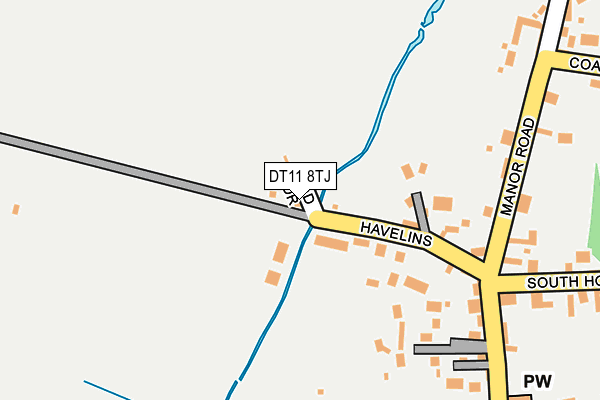
DT11 8TJ lies on Hod Drive in Stourpaine, Blandford Forum. DT11 8TJ is located in the Hill Forts & Upper Tarrants electoral ward, within the unitary authority of Dorset and the English Parliamentary constituency of North Dorset. The Sub Integrated Care Board (ICB) Location is NHS Dorset ICB - 11J and the police force is Dorset. This postcode has been in use since January 1980.


GetTheData
Source: OS OpenMap – Local (Ordnance Survey)
Source: OS VectorMap District (Ordnance Survey)
Licence: Open Government Licence (requires attribution)
| Easting | 385814 |
| Northing | 109572 |
| Latitude | 50.885453 |
| Longitude | -2.203032 |
GetTheData
Source: Open Postcode Geo
Licence: Open Government Licence
| Street | Hod Drive |
| Locality | Stourpaine |
| Town/City | Blandford Forum |
| Country | England |
| Postcode District | DT11 |
➜ See where DT11 is on a map ➜ Where is Stourpaine? | |
GetTheData
Source: Land Registry Price Paid Data
Licence: Open Government Licence
Elevation or altitude of DT11 8TJ as distance above sea level:
| Metres | Feet | |
|---|---|---|
| Elevation | 40m | 131ft |
Elevation is measured from the approximate centre of the postcode, to the nearest point on an OS contour line from OS Terrain 50, which has contour spacing of ten vertical metres.
➜ How high above sea level am I? Find the elevation of your current position using your device's GPS.
GetTheData
Source: Open Postcode Elevation
Licence: Open Government Licence
| Ward | Hill Forts & Upper Tarrants |
| Constituency | North Dorset |
GetTheData
Source: ONS Postcode Database
Licence: Open Government Licence
2024 5 APR £707,500 |
2011 28 APR £520,000 |
3, HOD DRIVE, STOURPAINE, BLANDFORD FORUM, DT11 8TJ 2003 8 AUG £525,000 |
GetTheData
Source: HM Land Registry Price Paid Data
Licence: Contains HM Land Registry data © Crown copyright and database right 2025. This data is licensed under the Open Government Licence v3.0.
| White Horse (Shaston Road) | Stourpaine | 380m |
| White Horse (Shaston Road) | Stourpaine | 397m |
| War Memorial (A357) | Durweston | 822m |
| War Memorial (A357) | Durweston | 826m |
| First School (Church Road) | Durweston | 1,112m |
GetTheData
Source: NaPTAN
Licence: Open Government Licence
| Percentage of properties with Next Generation Access | 100.0% |
| Percentage of properties with Superfast Broadband | 0.0% |
| Percentage of properties with Ultrafast Broadband | 0.0% |
| Percentage of properties with Full Fibre Broadband | 0.0% |
Superfast Broadband is between 30Mbps and 300Mbps
Ultrafast Broadband is > 300Mbps
| Percentage of properties unable to receive 2Mbps | 0.0% |
| Percentage of properties unable to receive 5Mbps | 0.0% |
| Percentage of properties unable to receive 10Mbps | 0.0% |
| Percentage of properties unable to receive 30Mbps | 100.0% |
GetTheData
Source: Ofcom
Licence: Ofcom Terms of Use (requires attribution)
GetTheData
Source: ONS Postcode Database
Licence: Open Government Licence

➜ Get more ratings from the Food Standards Agency
GetTheData
Source: Food Standards Agency
Licence: FSA terms & conditions
| Last Collection | |||
|---|---|---|---|
| Location | Mon-Fri | Sat | Distance |
| Durweston P.o. | 16:00 | 09:45 | 911m |
| Bryanston | 16:15 | 11:30 | 2,921m |
| The Kennels | 11:15 | 07:00 | 3,378m |
GetTheData
Source: Dracos
Licence: Creative Commons Attribution-ShareAlike
| Risk of DT11 8TJ flooding from rivers and sea | High |
| ➜ DT11 8TJ flood map | |
GetTheData
Source: Open Flood Risk by Postcode
Licence: Open Government Licence
The below table lists the International Territorial Level (ITL) codes (formerly Nomenclature of Territorial Units for Statistics (NUTS) codes) and Local Administrative Units (LAU) codes for DT11 8TJ:
| ITL 1 Code | Name |
|---|---|
| TLK | South West (England) |
| ITL 2 Code | Name |
| TLK2 | Dorset and Somerset |
| ITL 3 Code | Name |
| TLK25 | Dorset |
| LAU 1 Code | Name |
| E06000059 | Dorset |
GetTheData
Source: ONS Postcode Directory
Licence: Open Government Licence
The below table lists the Census Output Area (OA), Lower Layer Super Output Area (LSOA), and Middle Layer Super Output Area (MSOA) for DT11 8TJ:
| Code | Name | |
|---|---|---|
| OA | E00103623 | |
| LSOA | E01020444 | North Dorset 005A |
| MSOA | E02004259 | North Dorset 005 |
GetTheData
Source: ONS Postcode Directory
Licence: Open Government Licence
| DT11 8TH | Havelins | 119m |
| DT11 8TQ | Manor Road | 189m |
| DT11 8TG | South Holme | 296m |
| DT11 8TL | Coach Road | 332m |
| DT11 8JZ | Trinity Close | 361m |
| DT11 8SS | Church View | 380m |
| DT11 8TF | Bottom Road | 473m |
| DT11 8TE | Orchard Close | 489m |
| DT11 8TN | Hod View | 492m |
| DT11 8TA | Shaston Road | 518m |
GetTheData
Source: Open Postcode Geo; Land Registry Price Paid Data
Licence: Open Government Licence