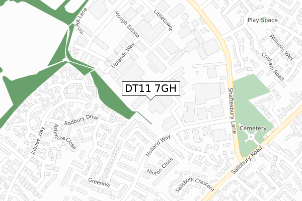
DT11 7GH is located in the Blandford electoral ward, within the unitary authority of Dorset and the English Parliamentary constituency of North Dorset. The Sub Integrated Care Board (ICB) Location is NHS Dorset ICB - 11J and the police force is Dorset. This postcode has been in use since September 2018.


GetTheData
Source: OS Open Zoomstack (Ordnance Survey)
Licence: Open Government Licence (requires attribution)
Attribution: Contains OS data © Crown copyright and database right 2025
Source: Open Postcode Geo
Licence: Open Government Licence (requires attribution)
Attribution: Contains OS data © Crown copyright and database right 2025; Contains Royal Mail data © Royal Mail copyright and database right 2025; Source: Office for National Statistics licensed under the Open Government Licence v.3.0
| Easting | 388894 |
| Northing | 107505 |
| Latitude | 50.866933 |
| Longitude | -2.159183 |
GetTheData
Source: Open Postcode Geo
Licence: Open Government Licence
| Country | England |
| Postcode District | DT11 |
➜ See where DT11 is on a map ➜ Where is Blandford Forum? | |
GetTheData
Source: Land Registry Price Paid Data
Licence: Open Government Licence
| Ward | Blandford |
| Constituency | North Dorset |
GetTheData
Source: ONS Postcode Database
Licence: Open Government Licence
| Hinton Close (Holland Way) | Blandford Forum | 205m |
| Industrial Estate | Blandford Forum | 220m |
| Industrial Estate | Blandford Forum | 222m |
| Lady Baden Powell Way (Shaftesbury Lane) | Blandford Forum | 316m |
| Hunt Road (Salisbury Road) | Blandford Forum | 338m |
GetTheData
Source: NaPTAN
Licence: Open Government Licence
| Median download speed | 14.5Mbps |
| Average download speed | 28.6Mbps |
| Maximum download speed | 63.80Mbps |
| Median upload speed | 1.1Mbps |
| Average upload speed | 7.4Mbps |
| Maximum upload speed | 20.00Mbps |
GetTheData
Source: Ofcom
Licence: Ofcom Terms of Use (requires attribution)
GetTheData
Source: ONS Postcode Database
Licence: Open Government Licence


➜ Get more ratings from the Food Standards Agency
GetTheData
Source: Food Standards Agency
Licence: FSA terms & conditions
| Last Collection | |||
|---|---|---|---|
| Location | Mon-Fri | Sat | Distance |
| Blandford Heights Ind Est | 17:15 | 11:00 | 375m |
| Queens Road | 16:00 | 11:30 | 490m |
| Milldown Road | 16:00 | 11:00 | 801m |
GetTheData
Source: Dracos
Licence: Creative Commons Attribution-ShareAlike
The below table lists the International Territorial Level (ITL) codes (formerly Nomenclature of Territorial Units for Statistics (NUTS) codes) and Local Administrative Units (LAU) codes for DT11 7GH:
| ITL 1 Code | Name |
|---|---|
| TLK | South West (England) |
| ITL 2 Code | Name |
| TLK2 | Dorset and Somerset |
| ITL 3 Code | Name |
| TLK25 | Dorset |
| LAU 1 Code | Name |
| E06000059 | Dorset |
GetTheData
Source: ONS Postcode Directory
Licence: Open Government Licence
The below table lists the Census Output Area (OA), Lower Layer Super Output Area (LSOA), and Middle Layer Super Output Area (MSOA) for DT11 7GH:
| Code | Name | |
|---|---|---|
| OA | E00171764 | |
| LSOA | E01020436 | North Dorset 007B |
| MSOA | E02004261 | North Dorset 007 |
GetTheData
Source: ONS Postcode Directory
Licence: Open Government Licence
| DT11 7RP | Liddington Crescent | 99m |
| DT11 7RS | Hinton Close | 184m |
| DT11 7UG | Blandford Heights | 203m |
| DT11 7XA | Mortain Close | 210m |
| DT11 7UJ | Badbury Drive | 213m |
| DT11 7UZ | Uplands Park | 224m |
| DT11 7UU | Old Farm Gardens | 232m |
| DT11 7UW | Jubilee Way | 245m |
| DT11 7RR | Marston Close | 245m |
| DT11 7TZ | Manningford Road | 264m |
GetTheData
Source: Open Postcode Geo; Land Registry Price Paid Data
Licence: Open Government Licence