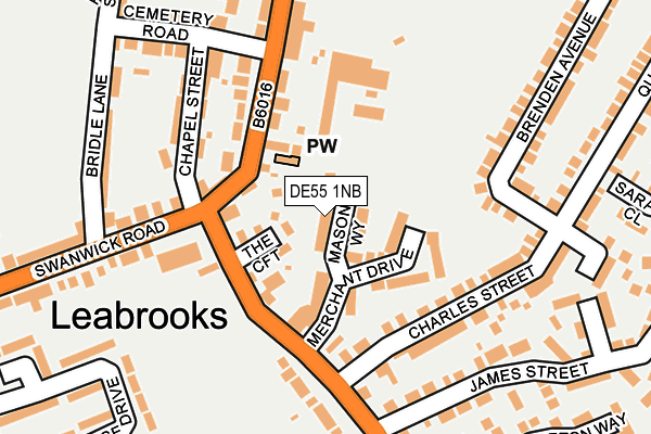
DE55 1NB is located in the Somercotes electoral ward, within the local authority district of Amber Valley and the English Parliamentary constituency of Amber Valley. The Sub Integrated Care Board (ICB) Location is NHS Derby and Derbyshire ICB - 15M and the police force is Derbyshire. This postcode has been in use since February 2017.


GetTheData
Source: OS OpenMap – Local (Ordnance Survey)
Source: OS VectorMap District (Ordnance Survey)
Licence: Open Government Licence (requires attribution)
| Easting | 442164 |
| Northing | 353376 |
| Latitude | 53.075975 |
| Longitude | -1.372081 |
GetTheData
Source: Open Postcode Geo
Licence: Open Government Licence
| Country | England |
| Postcode District | DE55 |
➜ See where DE55 is on a map ➜ Where is Leabrooks? | |
GetTheData
Source: Land Registry Price Paid Data
Licence: Open Government Licence
| Ward | Somercotes |
| Constituency | Amber Valley |
GetTheData
Source: ONS Postcode Database
Licence: Open Government Licence
2023 28 JUL £344,000 |
2021 31 AUG £270,000 |
25, MASON WAY, LEABROOKS, ALFRETON, DE55 1NB 2021 19 MAR £240,000 |
32, MASON WAY, LEABROOKS, ALFRETON, DE55 1NB 2021 12 MAR £210,000 |
26, MASON WAY, LEABROOKS, ALFRETON, DE55 1NB 2020 11 DEC £240,000 |
2020 30 NOV £297,500 |
30, MASON WAY, LEABROOKS, ALFRETON, DE55 1NB 2020 16 OCT £215,000 |
20, MASON WAY, LEABROOKS, ALFRETON, DE55 1NB 2020 16 SEP £275,000 |
9, MASON WAY, LEABROOKS, ALFRETON, DE55 1NB 2020 26 JUN £270,000 |
2020 7 FEB £267,000 |
GetTheData
Source: HM Land Registry Price Paid Data
Licence: Contains HM Land Registry data © Crown copyright and database right 2025. This data is licensed under the Open Government Licence v3.0.
| Corner (Greenhill Lane) | Leabrooks | 139m |
| Corner (Greenhill Lane) | Leabrooks | 157m |
| Bridle Lane (Swanwick Road) | Leabrooks | 180m |
| Leabrooks Road | Somercotes | 232m |
| Leabrooks Road | Somercotes | 247m |
| Alfreton Station | 2.7km |
GetTheData
Source: NaPTAN
Licence: Open Government Licence
| Percentage of properties with Next Generation Access | 88.9% |
| Percentage of properties with Superfast Broadband | 88.9% |
| Percentage of properties with Ultrafast Broadband | 0.0% |
| Percentage of properties with Full Fibre Broadband | 0.0% |
Superfast Broadband is between 30Mbps and 300Mbps
Ultrafast Broadband is > 300Mbps
| Median download speed | 66.9Mbps |
| Average download speed | 55.7Mbps |
| Maximum download speed | 80.00Mbps |
| Median upload speed | 19.5Mbps |
| Average upload speed | 13.5Mbps |
| Maximum upload speed | 20.00Mbps |
| Percentage of properties unable to receive 2Mbps | 0.0% |
| Percentage of properties unable to receive 5Mbps | 0.0% |
| Percentage of properties unable to receive 10Mbps | 0.0% |
| Percentage of properties unable to receive 30Mbps | 0.0% |
GetTheData
Source: Ofcom
Licence: Ofcom Terms of Use (requires attribution)
GetTheData
Source: ONS Postcode Database
Licence: Open Government Licence


➜ Get more ratings from the Food Standards Agency
GetTheData
Source: Food Standards Agency
Licence: FSA terms & conditions
| Last Collection | |||
|---|---|---|---|
| Location | Mon-Fri | Sat | Distance |
| Charles Street | 17:30 | 09:30 | 198m |
| Somercotes Post Office | 17:30 | 09:30 | 498m |
| Castleton Avenue | 17:30 | 09:30 | 499m |
GetTheData
Source: Dracos
Licence: Creative Commons Attribution-ShareAlike
The below table lists the International Territorial Level (ITL) codes (formerly Nomenclature of Territorial Units for Statistics (NUTS) codes) and Local Administrative Units (LAU) codes for DE55 1NB:
| ITL 1 Code | Name |
|---|---|
| TLF | East Midlands (England) |
| ITL 2 Code | Name |
| TLF1 | Derbyshire and Nottinghamshire |
| ITL 3 Code | Name |
| TLF13 | South and West Derbyshire |
| LAU 1 Code | Name |
| E07000032 | Amber Valley |
GetTheData
Source: ONS Postcode Directory
Licence: Open Government Licence
The below table lists the Census Output Area (OA), Lower Layer Super Output Area (LSOA), and Middle Layer Super Output Area (MSOA) for DE55 1NB:
| Code | Name | |
|---|---|---|
| OA | E00098458 | |
| LSOA | E01019470 | Amber Valley 004B |
| MSOA | E02004032 | Amber Valley 004 |
GetTheData
Source: ONS Postcode Directory
Licence: Open Government Licence
| DE55 1NA | Merchant Drive | 86m |
| DE55 1LX | The Croft | 88m |
| DE55 1LT | Main Road | 110m |
| DE55 1LA | Main Road | 120m |
| DE55 1LH | Chapel Street | 172m |
| DE55 1LU | Greenhill Lane | 179m |
| DE55 1LZ | Charles Street | 180m |
| DE55 1LD | Cemetery Road | 197m |
| DE55 4JD | Brenden Avenue | 209m |
| DE55 1LB | Sherwood Street | 225m |
GetTheData
Source: Open Postcode Geo; Land Registry Price Paid Data
Licence: Open Government Licence