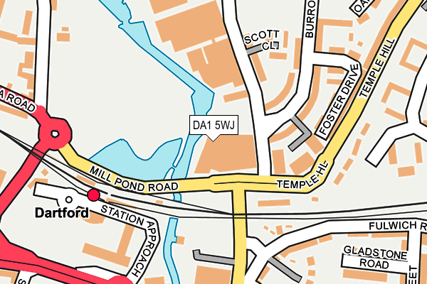
DA1 5WJ is located in the Town electoral ward, within the local authority district of Dartford and the English Parliamentary constituency of Dartford. The Sub Integrated Care Board (ICB) Location is NHS Kent and Medway ICB - 91Q and the police force is Kent. This postcode has been in use since July 2017.


GetTheData
Source: OS OpenMap – Local (Ordnance Survey)
Source: OS VectorMap District (Ordnance Survey)
Licence: Open Government Licence (requires attribution)
| Easting | 554465 |
| Northing | 174458 |
| Latitude | 51.448047 |
| Longitude | 0.221482 |
GetTheData
Source: Open Postcode Geo
Licence: Open Government Licence
| Country | England |
| Postcode District | DA1 |
➜ See where DA1 is on a map ➜ Where is Dartford? | |
GetTheData
Source: Land Registry Price Paid Data
Licence: Open Government Licence
| Ward | Town |
| Constituency | Dartford |
GetTheData
Source: ONS Postcode Database
Licence: Open Government Licence
| Mill Pond Road | Dartford | 118m |
| Mill Pond Road | Dartford | 136m |
| Railway Station (Station Approach) | Dartford | 193m |
| Home Gardens | Dartford | 244m |
| Home Gardens | Dartford | 251m |
| Dartford Station | 0.2km |
| Crayford Station | 3km |
| Stone Crossing Station | 3km |
GetTheData
Source: NaPTAN
Licence: Open Government Licence
| Percentage of properties with Next Generation Access | 100.0% |
| Percentage of properties with Superfast Broadband | 100.0% |
| Percentage of properties with Ultrafast Broadband | 100.0% |
| Percentage of properties with Full Fibre Broadband | 100.0% |
Superfast Broadband is between 30Mbps and 300Mbps
Ultrafast Broadband is > 300Mbps
| Median download speed | 100.0Mbps |
| Average download speed | 102.8Mbps |
| Maximum download speed | 350.00Mbps |
| Median upload speed | 1.1Mbps |
| Average upload speed | 1.1Mbps |
| Maximum upload speed | 1.26Mbps |
| Percentage of properties unable to receive 2Mbps | 0.0% |
| Percentage of properties unable to receive 5Mbps | 0.0% |
| Percentage of properties unable to receive 10Mbps | 0.0% |
| Percentage of properties unable to receive 30Mbps | 0.0% |
GetTheData
Source: Ofcom
Licence: Ofcom Terms of Use (requires attribution)
GetTheData
Source: ONS Postcode Database
Licence: Open Government Licence

➜ Get more ratings from the Food Standards Agency
GetTheData
Source: Food Standards Agency
Licence: FSA terms & conditions
| Last Collection | |||
|---|---|---|---|
| Location | Mon-Fri | Sat | Distance |
| Dartford Station | 18:30 | 12:00 | 221m |
| High Street | 18:30 | 12:15 | 475m |
| Temple Hill Post Office | 17:30 | 12:00 | 517m |
GetTheData
Source: Dracos
Licence: Creative Commons Attribution-ShareAlike
The below table lists the International Territorial Level (ITL) codes (formerly Nomenclature of Territorial Units for Statistics (NUTS) codes) and Local Administrative Units (LAU) codes for DA1 5WJ:
| ITL 1 Code | Name |
|---|---|
| TLJ | South East (England) |
| ITL 2 Code | Name |
| TLJ4 | Kent |
| ITL 3 Code | Name |
| TLJ43 | Kent Thames Gateway |
| LAU 1 Code | Name |
| E07000107 | Dartford |
GetTheData
Source: ONS Postcode Directory
Licence: Open Government Licence
The below table lists the Census Output Area (OA), Lower Layer Super Output Area (LSOA), and Middle Layer Super Output Area (MSOA) for DA1 5WJ:
| Code | Name | |
|---|---|---|
| OA | E00122591 | |
| LSOA | E01024148 | Dartford 001A |
| MSOA | E02005028 | Dartford 001 |
GetTheData
Source: ONS Postcode Directory
Licence: Open Government Licence
| DA1 5HT | St Vincents Villas | 193m |
| DA1 5TW | Burroughs Drive | 212m |
| DA1 1UG | Merryweather Close | 237m |
| DA1 5TX | Burroughs Drive | 260m |
| DA1 1BQ | Hythe Street | 265m |
| DA1 5SL | Knights Manor Way | 273m |
| DA1 5SJ | Knights Manor Way | 273m |
| DA1 5AE | Victoria Road | 276m |
| DA1 5UF | Oakes Crescent | 279m |
| DA1 1TU | Gladstone Road | 280m |
GetTheData
Source: Open Postcode Geo; Land Registry Price Paid Data
Licence: Open Government Licence