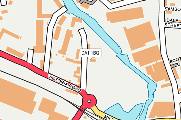
DA1 1BQ lies on Hythe Street in Dartford. DA1 1BQ is located in the Town electoral ward, within the local authority district of Dartford and the English Parliamentary constituency of Dartford. The Sub Integrated Care Board (ICB) Location is NHS Kent and Medway ICB - 91Q and the police force is Kent. This postcode has been in use since January 1980.


GetTheData
Source: OS OpenMap – Local (Ordnance Survey)
Source: OS VectorMap District (Ordnance Survey)
Licence: Open Government Licence (requires attribution)
| Easting | 554246 |
| Northing | 174607 |
| Latitude | 51.449445 |
| Longitude | 0.218370 |
GetTheData
Source: Open Postcode Geo
Licence: Open Government Licence
| Street | Hythe Street |
| Town/City | Dartford |
| Country | England |
| Postcode District | DA1 |
➜ See where DA1 is on a map ➜ Where is Dartford? | |
GetTheData
Source: Land Registry Price Paid Data
Licence: Open Government Licence
Elevation or altitude of DA1 1BQ as distance above sea level:
| Metres | Feet | |
|---|---|---|
| Elevation | 10m | 33ft |
Elevation is measured from the approximate centre of the postcode, to the nearest point on an OS contour line from OS Terrain 50, which has contour spacing of ten vertical metres.
➜ How high above sea level am I? Find the elevation of your current position using your device's GPS.
GetTheData
Source: Open Postcode Elevation
Licence: Open Government Licence
| Ward | Town |
| Constituency | Dartford |
GetTheData
Source: ONS Postcode Database
Licence: Open Government Licence
149, HYTHE STREET, DARTFORD, DA1 1BQ 2006 28 SEP £200,000 |
GetTheData
Source: HM Land Registry Price Paid Data
Licence: Contains HM Land Registry data © Crown copyright and database right 2025. This data is licensed under the Open Government Licence v3.0.
| Mill Pond Road | Dartford | 223m |
| Railway Station (Station Approach) | Dartford | 232m |
| Prospect Place (Hythe Street) | Dartford | 236m |
| Mill Pond Road | Dartford | 249m |
| The Base (Victoria Road) | Dartford | 265m |
| Dartford Station | 0.2km |
| Crayford Station | 2.7km |
| Slade Green Station | 2.8km |
GetTheData
Source: NaPTAN
Licence: Open Government Licence
GetTheData
Source: ONS Postcode Database
Licence: Open Government Licence


➜ Get more ratings from the Food Standards Agency
GetTheData
Source: Food Standards Agency
Licence: FSA terms & conditions
| Last Collection | |||
|---|---|---|---|
| Location | Mon-Fri | Sat | Distance |
| Dartford Station | 18:30 | 12:00 | 243m |
| High Street | 18:30 | 12:15 | 586m |
| Bean Road | 17:30 | 11:15 | 618m |
GetTheData
Source: Dracos
Licence: Creative Commons Attribution-ShareAlike
| Risk of DA1 1BQ flooding from rivers and sea | Low |
| ➜ DA1 1BQ flood map | |
GetTheData
Source: Open Flood Risk by Postcode
Licence: Open Government Licence
The below table lists the International Territorial Level (ITL) codes (formerly Nomenclature of Territorial Units for Statistics (NUTS) codes) and Local Administrative Units (LAU) codes for DA1 1BQ:
| ITL 1 Code | Name |
|---|---|
| TLJ | South East (England) |
| ITL 2 Code | Name |
| TLJ4 | Kent |
| ITL 3 Code | Name |
| TLJ43 | Kent Thames Gateway |
| LAU 1 Code | Name |
| E07000107 | Dartford |
GetTheData
Source: ONS Postcode Directory
Licence: Open Government Licence
The below table lists the Census Output Area (OA), Lower Layer Super Output Area (LSOA), and Middle Layer Super Output Area (MSOA) for DA1 1BQ:
| Code | Name | |
|---|---|---|
| OA | E00122761 | |
| LSOA | E01024180 | Dartford 003A |
| MSOA | E02005030 | Dartford 003 |
GetTheData
Source: ONS Postcode Directory
Licence: Open Government Licence
| DA1 1BN | Hythe Street | 54m |
| DA1 5AE | Victoria Road | 99m |
| DA1 5AJ | Victoria Road | 202m |
| DA1 5FS | Victoria Road | 258m |
| DA1 5BS | Riverside Industrial Estate | 319m |
| DA1 5TX | Burroughs Drive | 352m |
| DA1 2TJ | Kenwyn Road | 357m |
| DA1 2AD | Westgate Road | 361m |
| DA1 5TW | Burroughs Drive | 367m |
| DA1 2TG | Humber Road | 369m |
GetTheData
Source: Open Postcode Geo; Land Registry Price Paid Data
Licence: Open Government Licence