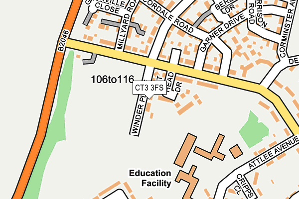
CT3 3FS is located in the Aylesham, Eythorne & Shepherdswell electoral ward, within the local authority district of Dover and the English Parliamentary constituency of Dover. The Sub Integrated Care Board (ICB) Location is NHS Kent and Medway ICB - 91Q and the police force is Kent. This postcode has been in use since June 2017.


GetTheData
Source: OS OpenMap – Local (Ordnance Survey)
Source: OS VectorMap District (Ordnance Survey)
Licence: Open Government Licence (requires attribution)
| Easting | 623162 |
| Northing | 152482 |
| Latitude | 51.227881 |
| Longitude | 1.194914 |
GetTheData
Source: Open Postcode Geo
Licence: Open Government Licence
| Country | England |
| Postcode District | CT3 |
➜ See where CT3 is on a map ➜ Where is Aylesham? | |
GetTheData
Source: Land Registry Price Paid Data
Licence: Open Government Licence
| Ward | Aylesham, Eythorne & Shepherdswell |
| Constituency | Dover |
GetTheData
Source: ONS Postcode Database
Licence: Open Government Licence
2022 30 SEP £452,500 |
14, WINDER PLACE, AYLESHAM, CANTERBURY, CT3 3FS 2021 16 DEC £334,995 |
16, WINDER PLACE, AYLESHAM, CANTERBURY, CT3 3FS 2021 25 NOV £329,995 |
26, WINDER PLACE, AYLESHAM, CANTERBURY, CT3 3FS 2021 23 SEP £329,995 |
75, WINDER PLACE, AYLESHAM, CANTERBURY, CT3 3FS 2021 27 MAY £318,995 |
79, WINDER PLACE, AYLESHAM, CANTERBURY, CT3 3FS 2021 27 MAY £349,995 |
73, WINDER PLACE, AYLESHAM, CANTERBURY, CT3 3FS 2020 29 OCT £349,995 |
71, WINDER PLACE, AYLESHAM, CANTERBURY, CT3 3FS 2020 29 OCT £349,995 |
69, WINDER PLACE, AYLESHAM, CANTERBURY, CT3 3FS 2020 14 OCT £318,995 |
67, WINDER PLACE, AYLESHAM, CANTERBURY, CT3 3FS 2020 10 JAN £317,995 |
GetTheData
Source: HM Land Registry Price Paid Data
Licence: Contains HM Land Registry data © Crown copyright and database right 2025. This data is licensed under the Open Government Licence v3.0.
| Dorman Avenue North (Adisham Road) | Aylesham | 214m |
| Attlee Avenue | Aylesham | 305m |
| Derwent Way (Dorman Avenue North) | Aylesham | 307m |
| Oakside Road | Aylesham | 359m |
| Cornwallis Avenue | Aylesham | 443m |
| Aylesham Station | 1km |
| Adisham Station | 1.5km |
| Snowdown Station | 1.9km |
GetTheData
Source: NaPTAN
Licence: Open Government Licence
| Percentage of properties with Next Generation Access | 100.0% |
| Percentage of properties with Superfast Broadband | 100.0% |
| Percentage of properties with Ultrafast Broadband | 100.0% |
| Percentage of properties with Full Fibre Broadband | 100.0% |
Superfast Broadband is between 30Mbps and 300Mbps
Ultrafast Broadband is > 300Mbps
| Median download speed | 360.0Mbps |
| Average download speed | 360.0Mbps |
| Maximum download speed | 360.00Mbps |
| Median upload speed | 360.0Mbps |
| Average upload speed | 360.0Mbps |
| Maximum upload speed | 360.00Mbps |
| Percentage of properties unable to receive 2Mbps | 0.0% |
| Percentage of properties unable to receive 5Mbps | 0.0% |
| Percentage of properties unable to receive 10Mbps | 0.0% |
| Percentage of properties unable to receive 30Mbps | 0.0% |
GetTheData
Source: Ofcom
Licence: Ofcom Terms of Use (requires attribution)
GetTheData
Source: ONS Postcode Database
Licence: Open Government Licence


➜ Get more ratings from the Food Standards Agency
GetTheData
Source: Food Standards Agency
Licence: FSA terms & conditions
| Last Collection | |||
|---|---|---|---|
| Location | Mon-Fri | Sat | Distance |
| Attlee Avenue | 16:15 | 09:00 | 276m |
| Hill Crescent | 16:15 | 09:00 | 402m |
| Aylesham Post Office | 17:00 | 09:30 | 514m |
GetTheData
Source: Dracos
Licence: Creative Commons Attribution-ShareAlike
The below table lists the International Territorial Level (ITL) codes (formerly Nomenclature of Territorial Units for Statistics (NUTS) codes) and Local Administrative Units (LAU) codes for CT3 3FS:
| ITL 1 Code | Name |
|---|---|
| TLJ | South East (England) |
| ITL 2 Code | Name |
| TLJ4 | Kent |
| ITL 3 Code | Name |
| TLJ44 | East Kent |
| LAU 1 Code | Name |
| E07000108 | Dover |
GetTheData
Source: ONS Postcode Directory
Licence: Open Government Licence
The below table lists the Census Output Area (OA), Lower Layer Super Output Area (LSOA), and Middle Layer Super Output Area (MSOA) for CT3 3FS:
| Code | Name | |
|---|---|---|
| OA | E00122806 | |
| LSOA | E01024192 | Dover 006C |
| MSOA | E02005046 | Dover 006 |
GetTheData
Source: ONS Postcode Directory
Licence: Open Government Licence
| CT3 3BP | Dorman Avenue North | 185m |
| CT3 3DB | Vale View Road | 213m |
| CT3 3EH | Cordale Road | 224m |
| CT3 3BW | Dorman Avenue North | 225m |
| CT3 3BZ | Newman Road | 238m |
| CT3 3BY | Newman Road | 252m |
| CT3 3EX | Chippers Walk | 269m |
| CT3 3BX | Cripps Close | 277m |
| CT3 3FD | Garner Drive | 285m |
| CT3 3FG | School Square | 287m |
GetTheData
Source: Open Postcode Geo; Land Registry Price Paid Data
Licence: Open Government Licence