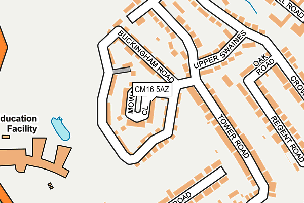
CM16 5AZ lies on Mowbray Close in Epping. CM16 5AZ is located in the Epping Lindsey and Thornwood Common electoral ward, within the local authority district of Epping Forest and the English Parliamentary constituency of Epping Forest. The Sub Integrated Care Board (ICB) Location is NHS Hertfordshire and West Essex ICB - 07H and the police force is Essex. This postcode has been in use since December 2014.


GetTheData
Source: OS OpenMap – Local (Ordnance Survey)
Source: OS VectorMap District (Ordnance Survey)
Licence: Open Government Licence (requires attribution)
| Easting | 545415 |
| Northing | 202071 |
| Latitude | 51.698557 |
| Longitude | 0.102762 |
GetTheData
Source: Open Postcode Geo
Licence: Open Government Licence
| Street | Mowbray Close |
| Town/City | Epping |
| Country | England |
| Postcode District | CM16 |
➜ See where CM16 is on a map ➜ Where is Epping? | |
GetTheData
Source: Land Registry Price Paid Data
Licence: Open Government Licence
Elevation or altitude of CM16 5AZ as distance above sea level:
| Metres | Feet | |
|---|---|---|
| Elevation | 100m | 328ft |
Elevation is measured from the approximate centre of the postcode, to the nearest point on an OS contour line from OS Terrain 50, which has contour spacing of ten vertical metres.
➜ How high above sea level am I? Find the elevation of your current position using your device's GPS.
GetTheData
Source: Open Postcode Elevation
Licence: Open Government Licence
| Ward | Epping Lindsey And Thornwood Common |
| Constituency | Epping Forest |
GetTheData
Source: ONS Postcode Database
Licence: Open Government Licence
2024 15 AUG £795,000 |
21, MOWBRAY CLOSE, EPPING, CM16 5AZ 2016 2 JUN £705,000 |
2015 11 DEC £725,000 |
20, MOWBRAY CLOSE, EPPING, CM16 5AZ 2015 7 MAY £635,000 |
21, MOWBRAY CLOSE, EPPING, CM16 5AZ 2015 30 APR £650,000 |
GetTheData
Source: HM Land Registry Price Paid Data
Licence: Contains HM Land Registry data © Crown copyright and database right 2025. This data is licensed under the Open Government Licence v3.0.
| Infants School (Coronation Hill) | Epping | 406m |
| Infants School (Lower Swaines) | Epping | 407m |
| Tesco Store (High Street) | Epping | 408m |
| Tesco Store (High Street) | Epping | 435m |
| Bury Lane (High Road) | Epping | 533m |
| Epping Underground Station | Epping | 936m |
GetTheData
Source: NaPTAN
Licence: Open Government Licence
| Percentage of properties with Next Generation Access | 100.0% |
| Percentage of properties with Superfast Broadband | 100.0% |
| Percentage of properties with Ultrafast Broadband | 0.0% |
| Percentage of properties with Full Fibre Broadband | 0.0% |
Superfast Broadband is between 30Mbps and 300Mbps
Ultrafast Broadband is > 300Mbps
| Median download speed | 54.3Mbps |
| Average download speed | 47.3Mbps |
| Maximum download speed | 76.81Mbps |
| Median upload speed | 12.7Mbps |
| Average upload speed | 11.3Mbps |
| Maximum upload speed | 20.00Mbps |
| Percentage of properties unable to receive 2Mbps | 0.0% |
| Percentage of properties unable to receive 5Mbps | 0.0% |
| Percentage of properties unable to receive 10Mbps | 0.0% |
| Percentage of properties unable to receive 30Mbps | 0.0% |
GetTheData
Source: Ofcom
Licence: Ofcom Terms of Use (requires attribution)
Estimated total energy consumption in CM16 5AZ by fuel type, 2015.
| Consumption (kWh) | 501,266 |
|---|---|
| Meter count | 40 |
| Mean (kWh/meter) | 12,532 |
| Median (kWh/meter) | 11,646 |
| Consumption (kWh) | 170,044 |
|---|---|
| Meter count | 47 |
| Mean (kWh/meter) | 3,618 |
| Median (kWh/meter) | 3,358 |
GetTheData
Source: Postcode level gas estimates: 2015 (experimental)
Source: Postcode level electricity estimates: 2015 (experimental)
Licence: Open Government Licence
GetTheData
Source: ONS Postcode Database
Licence: Open Government Licence


➜ Get more ratings from the Food Standards Agency
GetTheData
Source: Food Standards Agency
Licence: FSA terms & conditions
| Last Collection | |||
|---|---|---|---|
| Location | Mon-Fri | Sat | Distance |
| St Johns Road | 17:45 | 11:15 | 384m |
| Hemnall Street | 17:00 | 11:15 | 556m |
| Epping Pdo | 17:30 | 12:30 | 715m |
GetTheData
Source: Dracos
Licence: Creative Commons Attribution-ShareAlike
The below table lists the International Territorial Level (ITL) codes (formerly Nomenclature of Territorial Units for Statistics (NUTS) codes) and Local Administrative Units (LAU) codes for CM16 5AZ:
| ITL 1 Code | Name |
|---|---|
| TLH | East |
| ITL 2 Code | Name |
| TLH3 | Essex |
| ITL 3 Code | Name |
| TLH35 | West Essex |
| LAU 1 Code | Name |
| E07000072 | Epping Forest |
GetTheData
Source: ONS Postcode Directory
Licence: Open Government Licence
The below table lists the Census Output Area (OA), Lower Layer Super Output Area (LSOA), and Middle Layer Super Output Area (MSOA) for CM16 5AZ:
| Code | Name | |
|---|---|---|
| OA | E00110547 | |
| LSOA | E01021763 | Epping Forest 005D |
| MSOA | E02004531 | Epping Forest 005 |
GetTheData
Source: ONS Postcode Directory
Licence: Open Government Licence
| CM16 5AF | Buckingham Road | 71m |
| CM16 5AN | Ambrose Crescent | 85m |
| CM16 5AG | Buckingham Road | 88m |
| CM16 5EN | Tower Road | 133m |
| CM16 5EW | Tower Road | 141m |
| CM16 5EP | Upper Swaines | 158m |
| CM16 5ET | Bury Road | 187m |
| CM16 5DH | Crows Road | 204m |
| CM16 5DJ | Oak Road | 216m |
| CM16 5EU | Bury Road | 217m |
GetTheData
Source: Open Postcode Geo; Land Registry Price Paid Data
Licence: Open Government Licence