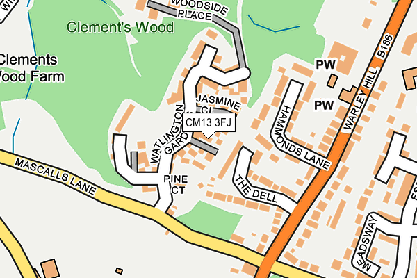
CM13 3FJ is located in the Warley electoral ward, within the local authority district of Brentwood and the English Parliamentary constituency of Brentwood and Ongar. The Sub Integrated Care Board (ICB) Location is NHS Mid and South Essex ICB - 99E and the police force is Essex. This postcode has been in use since May 2016.


GetTheData
Source: OS OpenMap – Local (Ordnance Survey)
Source: OS VectorMap District (Ordnance Survey)
Licence: Open Government Licence (requires attribution)
| Easting | 558772 |
| Northing | 191823 |
| Latitude | 51.602871 |
| Longitude | 0.291229 |
GetTheData
Source: Open Postcode Geo
Licence: Open Government Licence
| Country | England |
| Postcode District | CM13 |
➜ See where CM13 is on a map ➜ Where is Brentwood? | |
GetTheData
Source: Land Registry Price Paid Data
Licence: Open Government Licence
Elevation or altitude of CM13 3FJ as distance above sea level:
| Metres | Feet | |
|---|---|---|
| Elevation | 100m | 328ft |
Elevation is measured from the approximate centre of the postcode, to the nearest point on an OS contour line from OS Terrain 50, which has contour spacing of ten vertical metres.
➜ How high above sea level am I? Find the elevation of your current position using your device's GPS.
GetTheData
Source: Open Postcode Elevation
Licence: Open Government Licence
| Ward | Warley |
| Constituency | Brentwood And Ongar |
GetTheData
Source: ONS Postcode Database
Licence: Open Government Licence
2023 23 JUN £655,000 |
4, SYCAMORE CLOSE, GREAT WARLEY, BRENTWOOD, CM13 3FJ 2016 28 JUL £859,995 |
2, SYCAMORE CLOSE, GREAT WARLEY, BRENTWOOD, CM13 3FJ 2016 25 MAY £522,495 |
1, SYCAMORE CLOSE, GREAT WARLEY, BRENTWOOD, CM13 3FJ 2016 5 MAY £539,995 |
2016 24 MAR £549,995 |
GetTheData
Source: HM Land Registry Price Paid Data
Licence: Contains HM Land Registry data © Crown copyright and database right 2025. This data is licensed under the Open Government Licence v3.0.
| The Horse & Groom (Warley Hill) | Warley | 164m |
| The Horse & Groom (Warley Road) | Warley | 260m |
| Walter Boyce Centre (Warley Hill) | Warley | 284m |
| Walter Boyce Centre (Warley Hill) | Warley | 323m |
| The Drive | Warley | 441m |
| Brentwood Station | 1.3km |
| Shenfield Station | 4.1km |
| Harold Wood Station | 4.2km |
GetTheData
Source: NaPTAN
Licence: Open Government Licence
| Percentage of properties with Next Generation Access | 100.0% |
| Percentage of properties with Superfast Broadband | 100.0% |
| Percentage of properties with Ultrafast Broadband | 0.0% |
| Percentage of properties with Full Fibre Broadband | 0.0% |
Superfast Broadband is between 30Mbps and 300Mbps
Ultrafast Broadband is > 300Mbps
| Percentage of properties unable to receive 2Mbps | 0.0% |
| Percentage of properties unable to receive 5Mbps | 0.0% |
| Percentage of properties unable to receive 10Mbps | 0.0% |
| Percentage of properties unable to receive 30Mbps | 0.0% |
GetTheData
Source: Ofcom
Licence: Ofcom Terms of Use (requires attribution)
GetTheData
Source: ONS Postcode Database
Licence: Open Government Licence


➜ Get more ratings from the Food Standards Agency
GetTheData
Source: Food Standards Agency
Licence: FSA terms & conditions
| Last Collection | |||
|---|---|---|---|
| Location | Mon-Fri | Sat | Distance |
| Warley Common, | 17:10 | 12:00 | 523m |
| Eagle Way | 16:00 | 10:30 | 613m |
| Hampden Crescent | 17:30 | 09:25 | 907m |
GetTheData
Source: Dracos
Licence: Creative Commons Attribution-ShareAlike
The below table lists the International Territorial Level (ITL) codes (formerly Nomenclature of Territorial Units for Statistics (NUTS) codes) and Local Administrative Units (LAU) codes for CM13 3FJ:
| ITL 1 Code | Name |
|---|---|
| TLH | East |
| ITL 2 Code | Name |
| TLH3 | Essex |
| ITL 3 Code | Name |
| TLH36 | Heart of Essex |
| LAU 1 Code | Name |
| E07000068 | Brentwood |
GetTheData
Source: ONS Postcode Directory
Licence: Open Government Licence
The below table lists the Census Output Area (OA), Lower Layer Super Output Area (LSOA), and Middle Layer Super Output Area (MSOA) for CM13 3FJ:
| Code | Name | |
|---|---|---|
| OA | E00109096 | |
| LSOA | E01021473 | Brentwood 008D |
| MSOA | E02004471 | Brentwood 008 |
GetTheData
Source: ONS Postcode Directory
Licence: Open Government Licence
| CM13 3AL | The Dell | 85m |
| CM13 3AQ | Hammonds Lane | 91m |
| CM13 3AH | Hammonds Lane | 140m |
| CM13 3AG | Warley Hill | 141m |
| CM14 5HX | Mascalls Lane | 145m |
| CM13 3AJ | Warley Hill | 177m |
| CM13 3AB | Warley Hill | 192m |
| CM13 3AE | Warley Road | 205m |
| CM13 3AD | Eagle Way | 222m |
| CM13 3AA | Warley Hill | 225m |
GetTheData
Source: Open Postcode Geo; Land Registry Price Paid Data
Licence: Open Government Licence