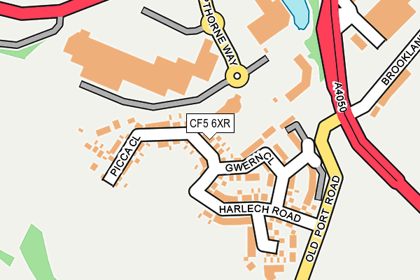
CF5 6XR is located in the Wenvoe electoral ward, within the unitary authority of Vale of Glamorgan and the Welsh Parliamentary constituency of Vale of Glamorgan. The Local Health Board is Cardiff and Vale University and the police force is South Wales. This postcode has been in use since March 2017.


GetTheData
Source: OS OpenMap – Local (Ordnance Survey)
Source: OS VectorMap District (Ordnance Survey)
Licence: Open Government Licence (requires attribution)
| Easting | 311540 |
| Northing | 174476 |
| Latitude | 51.462319 |
| Longitude | -3.274743 |
GetTheData
Source: Open Postcode Geo
Licence: Open Government Licence
| Country | Wales |
| Postcode District | CF5 |
➜ See where CF5 is on a map ➜ Where is Cardiff? | |
GetTheData
Source: Land Registry Price Paid Data
Licence: Open Government Licence
| Ward | Wenvoe |
| Constituency | Vale Of Glamorgan |
GetTheData
Source: ONS Postcode Database
Licence: Open Government Licence
2024 11 JAN £305,000 |
2022 14 DEC £395,000 |
2022 14 APR £312,000 |
2021 2 DEC £265,000 |
2021 30 JUN £460,000 |
2021 7 MAY £373,500 |
2021 26 FEB £330,000 |
2021 12 FEB £245,000 |
2020 19 NOV £355,000 |
76, PICCA CLOSE, CARDIFF, CF5 6XR 2019 20 DEC £429,995 |
GetTheData
Source: HM Land Registry Price Paid Data
Licence: Contains HM Land Registry data © Crown copyright and database right 2024. This data is licensed under the Open Government Licence v3.0.
| Culverhouse Cross (A48) | Culverhouse Cross | 206m |
| Vale Gate (Port Road) | Culverhouse Cross | 326m |
| Vale Gate (Port Road) | Culverhouse Cross | 335m |
| Ruhr Cross (Port Road) | Culverhouse Cross | 359m |
| Culverhouse Cross (A48) | Culverhouse Cross | 359m |
| Waun-gron Park Station | 4.3km |
| Fairwater Station | 4.5km |
| Danescourt Station | 5.1km |
GetTheData
Source: NaPTAN
Licence: Open Government Licence
| Percentage of properties with Next Generation Access | 100.0% |
| Percentage of properties with Superfast Broadband | 100.0% |
| Percentage of properties with Ultrafast Broadband | 0.0% |
| Percentage of properties with Full Fibre Broadband | 0.0% |
Superfast Broadband is between 30Mbps and 300Mbps
Ultrafast Broadband is > 300Mbps
| Median download speed | 4.9Mbps |
| Average download speed | 14.3Mbps |
| Maximum download speed | 79.99Mbps |
| Median upload speed | 0.8Mbps |
| Average upload speed | 3.1Mbps |
| Maximum upload speed | 20.00Mbps |
| Percentage of properties unable to receive 2Mbps | 0.0% |
| Percentage of properties unable to receive 5Mbps | 0.0% |
| Percentage of properties unable to receive 10Mbps | 0.0% |
| Percentage of properties unable to receive 30Mbps | 0.0% |
GetTheData
Source: Ofcom
Licence: Ofcom Terms of Use (requires attribution)
GetTheData
Source: ONS Postcode Database
Licence: Open Government Licence


➜ Get more ratings from the Food Standards Agency
GetTheData
Source: Food Standards Agency
Licence: FSA terms & conditions
| Last Collection | |||
|---|---|---|---|
| Location | Mon-Fri | Sat | Distance |
| The Court | 15:30 | 10:30 | 1,766m |
| Caerau Post Office | 17:30 | 12:00 | 2,835m |
| The Tumble | 18:30 | 11:00 | 3,977m |
GetTheData
Source: Dracos
Licence: Creative Commons Attribution-ShareAlike
The below table lists the International Territorial Level (ITL) codes (formerly Nomenclature of Territorial Units for Statistics (NUTS) codes) and Local Administrative Units (LAU) codes for CF5 6XR:
| ITL 1 Code | Name |
|---|---|
| TLL | Wales |
| ITL 2 Code | Name |
| TLL2 | East Wales |
| ITL 3 Code | Name |
| TLL22 | Cardiff and Vale of Glamorgan |
| LAU 1 Code | Name |
| W06000014 | Vale of Glamorgan |
GetTheData
Source: ONS Postcode Directory
Licence: Open Government Licence
The below table lists the Census Output Area (OA), Lower Layer Super Output Area (LSOA), and Middle Layer Super Output Area (MSOA) for CF5 6XR:
| Code | Name | |
|---|---|---|
| OA | W00005990 | |
| LSOA | W01001136 | The Vale of Glamorgan 003D |
| MSOA | W02000239 | The Vale of Glamorgan 003 |
GetTheData
Source: ONS Postcode Directory
Licence: Open Government Licence
| CF5 6EH | Valegate Retail Park | 151m |
| CF5 6XN | Harlech Road | 225m |
| CF5 5TH | Brooklands Terrace | 410m |
| CF5 6XW | Culverhouse Cross | 456m |
| CF5 6SA | The Tumble | 497m |
| CF5 6BL | Seaview Cottages | 662m |
| CF5 6BG | 668m | |
| CF5 5TX | Heol Collen | 669m |
| CF5 6BJ | Chapel Terrace | 678m |
| CF5 4SA | Patreane Way | 709m |
GetTheData
Source: Open Postcode Geo; Land Registry Price Paid Data
Licence: Open Government Licence